
| Blayney Shire New South Wales | |||||||||||||||
|---|---|---|---|---|---|---|---|---|---|---|---|---|---|---|---|

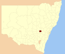
Location in New South Wales
| |||||||||||||||

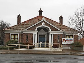
Council Chambers, Blayney
| |||||||||||||||
| Coordinates | 33°32′S 149°15′E / 33.533°S 149.250°E / -33.533; 149.250 | ||||||||||||||
| Population |
| ||||||||||||||
| • Density | 4.7587/km2 (12.325/sq mi) | ||||||||||||||
| Area | 1,525 km2 (588.8 sq mi) | ||||||||||||||
| Mayor | Scott Ferguson (Unaligned) | ||||||||||||||
| Council seat | Blayney[3] | ||||||||||||||
| Region | Central West | ||||||||||||||
| State electorate(s) | Bathurst | ||||||||||||||
| Federal division(s) | Calare | ||||||||||||||
 | |||||||||||||||
| Website | Blayney Shire | ||||||||||||||
| |||||||||||||||
Blayney Shire is a local government area in the Central West region of New South Wales, Australia. The Shire is located adjacent to the Mid-Western Highway and the Main Western railway line, and is centred on the town of Blayney.
Blayney Shire consists of approximately 1,600 square kilometres (620 sq mi) of well watered, gently undulating to hilly country and the climate is partially suitable for cool climate crops and trees. There is also significant mining industry in the shire.
Towns and localities within the Blayney Shire are:
This section needs expansion with: the 2011 census and the 2016 census data. You can help by adding to it. (July 2017)
|
| Selected historical census data for Blayney Shire local government area | ||||||
|---|---|---|---|---|---|---|
| Census year | 2011[4] | 2016[1] | ||||
| Population | Estimated residents on census night | 6,985 | ||||
| LGA rank in terms of size within New South Wales | 100th | |||||
| % of New South Wales population | ||||||
| % of Australian population | ||||||
| Cultural and language diversity | ||||||
| Ancestry, top responses |
Australian | 35.0% | 35.4% | |||
| English | 32.0% | 31.1% | ||||
| Irish | 11.1% | 10.9% | ||||
| Chinese | 7.4% | 7.4% | ||||
| German | 2.3% | 2.4% | ||||
| Language, top responses (other than English) |
German | n/a | 0.2% | |||
| Arabic | 0.2% | 0.2% | ||||
| Cantonese | n/a | 0.2% | ||||
| Tamil | n/a | 0.1% | ||||
| French | n/a | 0.1% | ||||
| Religious affiliation | ||||||
| Religious affiliation, top responses |
Catholic | 31.0% | 28.6% | |||
| Anglican | 27.9% | 24.2% | ||||
| No religion | 14.4% | 20.8% | ||||
| Not stated | not reported | 8.5% | ||||
| Uniting Church | 7.6% | 6.8% | ||||
| Median weekly incomes | ||||||
| Personal income | Median weekly personal income | A$553 | A$620 | |||
| % of Australian median income | % | % | ||||
| Family income | Median weekly family income | A$1376 | A$1581 | |||
| % of Australian median income | % | % | ||||
| Household income | Median weekly household income | A$1092 | A$1227 | |||
| % of Australian median income | % | % | ||||
Blayney Shire Council is composed of seven councillors elected proportionally as a single ward. All councillors are elected for a fixed four-year term of office. The mayor is elected by the councillors at the first meeting of the council. The most recent election was held on 4 December 2021, and the makeup of the council is as follows:[5]
| Party | Councillors | |
|---|---|---|
| Independents and Unaligned | 7 | |
| Total | 7 | |
The current Council, elected in 2021, in order of election, is:[5]
| Councillor | Party | Notes | |
|---|---|---|---|
| Bruce Reynolds | Independent | ||
| Michelle Pryse Jones | Independent | ||
| Scott Ferguson | Unaligned | Mayor[6] | |
| Craig Gosewisch | Independent | ||
| Allan Ewin | Independent | ||
| David Somervaille | Independent | Deputy Mayor[6] | |
| John Newstead | Independent | ||
| Party | Candidate | Votes | % | ±% | |
|---|---|---|---|---|---|
| Independent | Scott Ferguson (elected) | 1,036 | 22.7 | ||
| Independent | Bruce Reynolds (elected) | 635 | 13.9 | ||
| Independent | Michelle Pryse Jones (elected) | 605 | 13.3 | ||
| Independent | Craig Gosewisch (elected) | 559 | 12.3 | ||
| Independent | Allan Ewin (elected) | 526 | 11.5 | ||
| Independent | David Somervaille (elected) | 443 | 9.7 | ||
| Independent | John Newstead (elected) | 416 | 9.1 | ||
| Independent | Iris Dorsett | 340 | 7.5 | ||
| Total formal votes | 4,560 | 95.3 | |||
| Informal votes | 224 | 4.7 | |||
| Turnout | 4,784 | 87.7 | |||
| Party | Candidate | Votes | % | ±% | |
|---|---|---|---|---|---|
| Independent | Scott Ferguson (elected) | 1,329 | 30.9 | +19.4 | |
| Independent | Allan Ewin (elected) | 605 | 14.1 | −3.9 | |
| Independent | David Kingham (elected) | 447 | 10.4 | −0.1 | |
| Country Labor | Scott Denton (elected) | 418 | 9.7 | +9.7 | |
| Independent | John Newstead (elected) | 416 | 9.1 | ||
| Independent | Bruce Reynolds (elected) | 393 | 9.1 | +9.1 | |
| Independent | David Somervaille (elected) | 311 | 7.2 | −0.1 | |
| Greens | 272 | 6.3 | +6.3 | ||
| Independent | Nyree Reynolds | 139 | 3.2 | +3.2 | |
| Total formal votes | 4,299 | 94.82 | |||
| Informal votes | 235 | 5.18 | |||
| Turnout | 4,784 | 85.73 | |||
A2015 review of local government boundaries recommended that the Blayney Shire merge with the Cabonne Shire and the City of Orange to form a new council with an area of 7,833 square kilometres (3,024 sq mi) and support a population of approximately 63,000.[9] Despite originally planning for the amalgamation to go ahead, the merger scheduled for May 2016 was delayed due to legal action, and in February 2017 the NSW Government decided not to proceed with the amalgamation.[10][11][12]
![]() Media related to Blayney Shire at Wikimedia Commons
Media related to Blayney Shire at Wikimedia Commons
|
| |||||||
|---|---|---|---|---|---|---|---|
| Metropolitan Sydney |
| ||||||
| Mid North Coast |
| ||||||
| Murray |
| ||||||
| Murrumbidgee |
| ||||||
| Hunter |
| ||||||
| Illawarra |
| ||||||
| Richmond Tweed |
| ||||||
| Southeastern |
| ||||||
| Northern |
| ||||||
| Central West |
| ||||||
| North Western |
| ||||||
| Far West |
| ||||||
| External territories |
| ||||||
This New South Wales geography article is a stub. You can help Wikipedia by expanding it. |