Jump to content


Main menu


Navigation  


Main page
Contents
Current events
Random article
About Wikipedia
Contact us
Donate


Contribute  


Help
Learn to edit
Community portal
Recent changes
Upload file


Search  


Create account

Log in


Create account
 Log in


Pages for logged out editors learn more  


Contributions
Talk


Contents


(Top)


1 Heritage listings  


2 Council  


2.1  Current composition and election method  


3 Localities  


4 References  


5 External links  


Wentworth Shire


Cebuano
Deutsch
Français
Italiano
Nederlands
Svenska
 

Edit links


Article
Talk


Read
Edit
View history


Tools


Actions  


Read
Edit
View history


General  


What links here
Related changes
Upload file
Special pages
Permanent link
Page information
Cite this page
Get shortened URL
Download QR code
Wikidata item


Print/export  


Download as PDF
Printable version


Appearance


Coordinates: 34°05S 141°54E / 34.083°S 141.900°E / -34.083; 141.900
 

From Wikipedia, the free encyclopedia


Wentworth Shire
New South Wales
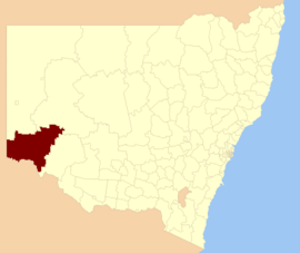
Location in New South Wales
Coordinates34°05′S 141°54′E / 34.083°S 141.900°E / -34.083; 141.900
Population7,453 (LGA 2021)[1]
 • Density0.26/km2 (0.67/sq mi)
Established23 January 1879[2]
Area26,269 km2 (10,142.5 sq mi)
MayorDaniel Linklater (Independent)
Council seatWentworth
RegionFar West
State electorate(s)Murray
Federal division(s)Farrer
WebsiteWentworth Shire
LGAs around Wentworth Shire:
OACDT (SA) Unincorporated Far West Central Darling
OACDT (SA) Wentworth Shire Balranald
Renmark Paringa (SA) Mildura (Vic) Mildura (Vic)

Wentworth Shire is a local government area in the far south-west Riverina region of New South Wales, Australia. This Shire is located adjacent to the Murray and Darling Rivers. The Shire's major roads are the Sturt and the Silver City Highways. The Shire includes the towns of Wentworth, Buronga, Gol Gol, Dareton and Pooncarie. The shire's namesake is explorer and politician William Wentworth.[3]

The mayor of Wentworth Shire Council is Cr. Daniel Linklater, an Independent politician.

Heritage listings[edit]

Wentworth Shire has a number of heritage-listed sites, including:

Council[edit]

The area of Wentworth was proclaimed a municipality on 23 January 1879.[2] The first Mayor was Mr. W. Gunn who held office from 1879 to 1880.[9]

Current composition and election method[edit]

Wentworth Shire Council is composed of nine councillors elected proportionally as a single ward. All councillors are elected for a fixed four-year term of office. The mayor is elected by the councillors at the first meeting of the council. The most recent election was held on 4 December 2021 and the current makeup of the council is as follows:[10]

Party Councillors
  Independents and Unaligned 9
Total 9

The current Council, elected in 2021, in order of election, is:[10]

Councillor Party Notes
  Peter Crisp Independent
  Steve Cooper Independent
  Tim Elstone Independent
  Daniel Linklater Independent Mayor 2023–[11]
  Susan Nichols Independent Deputy Mayor 2023–[11]
  Greg Evans Independent
  Brian Beaumont Independent
  Jo Rodda Unaligned
  Steve Heywood Unaligned Passed away 7 February 2024[11]

Localities[edit]

Locality population 2016 2021
Arumpo 34 40
Buronga 1,212 1,252
Curlwaa 393 496
Dareton 501 456
Ellerslie 82 56
Gol Gol 1,523 1,596
Mourquong 79 75
Pomona 161 167
Pooncarie 166 226
Wentworth 1,437 1,577

References[edit]

  1. ^ Australian Bureau of Statistics (28 June 2022). "Wentworth (Local Government Area)". Australian Census 2021 QuickStats. Retrieved 28 June 2022. Edit this at Wikidata
  • ^ a b "Wentworth History". Wentworth Shire Council. Retrieved 23 January 2010.
  • ^ "Wentworth – A Brief History". Wentworth Shire Council. Archived from the original on 20 May 2024. Retrieved 8 December 2023.
  • ^ "Rodney – paddle steamer". New South Wales State Heritage Register. Department of Planning & Environment. H01776. Retrieved 18 May 2018. Text is licensed by State of New South Wales (Department of Planning and Environment) under CC-BY 4.0 licence.
  • ^ "Old Wentworth Gaol". New South Wales State Heritage Register. Department of Planning & Environment. H01982. Retrieved 18 May 2018. Text is licensed by State of New South Wales (Department of Planning and Environment) under CC-BY 4.0 licence.
  • ^ "St. Ignatius School". New South Wales State Heritage Register. Department of Planning & Environment. H01507. Retrieved 18 May 2018. Text is licensed by State of New South Wales (Department of Planning and Environment) under CC-BY 4.0 licence.
  • ^ "St. John's Anglican Church and Rectory". New South Wales State Heritage Register. Department of Planning & Environment. H00661. Retrieved 18 May 2018. Text is licensed by State of New South Wales (Department of Planning and Environment) under CC-BY 4.0 licence.
  • ^ "Avoca Homestead Complex". New South Wales State Heritage Register. Department of Planning & Environment. H01971. Retrieved 18 May 2018. Text is licensed by State of New South Wales (Department of Planning and Environment) under CC-BY 4.0 licence.
  • ^ "Past Mayors & Presidents". Wentworth Shire Council. Archived from the original on 15 June 2016. Retrieved 23 January 2010.
  • ^ a b "Wentworth Councillor Election". NSW Electoral Commission. 21 December 2021. Archived from the original on 20 May 2024. Retrieved 20 May 2024. The following candidates were declared elected on 21 December 2021: Peter CRISP Steve COOPER (IND) Tim ELSTONE (IND) Daniel LINKLATER (IND) Susan NICHOLS (IND) Greg EVANS (IND) Brian BEAUMONT Jo RODDA Steve HEYWOOD (IND)
  • ^ a b c "Councillors". Wentworth Shire Council. 20 September 2023. Archived from the original on 20 May 2024. Retrieved 20 May 2024.
  • External links[edit]


  • t
  • e

  • Retrieved from "https://en.wikipedia.org/w/index.php?title=Wentworth_Shire&oldid=1224752585"

    Categories: 
    Wentworth Shire
    Local government areas of New South Wales
    New South Wales geography stubs
    Hidden categories: 
    Pages using gadget WikiMiniAtlas
    Use dmy dates from December 2021
    Use Australian English from September 2012
    All Wikipedia articles written in Australian English
    Articles with short description
    Short description matches Wikidata
    Coordinates on Wikidata
    Australian place articles using Wikidata population values
    Pages using infobox Australian place with an implicitly suppressed location map
    Articles with ISNI identifiers
    Articles with VIAF identifiers
    All stub articles


    This page was last edited on 20 May 2024, at 07:22 (UTC).

    Text is available under the Creative Commons Attribution-ShareAlike License 4.0; additional terms may apply. By using this site, you agree to the Terms of Use and Privacy Policy. Wikipedia® is a registered trademark of the Wikimedia Foundation, Inc., a non-profit organization.


    Privacy policy

    About Wikipedia

    Disclaimers

    Contact Wikipedia

    Code of Conduct

    Developers

    Statistics

    Cookie statement

    Mobile view


    Wikimedia Foundation
    Powered by MediaWiki