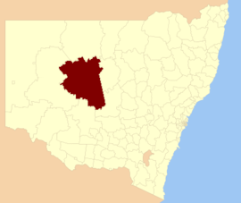

| Cobar Shire New South Wales | |||||||||||||||
|---|---|---|---|---|---|---|---|---|---|---|---|---|---|---|---|

Location in New South Wales
| |||||||||||||||
| Coordinates | 31°29′54″S 145°40′04″E / 31.49833°S 145.66778°E / -31.49833; 145.66778 | ||||||||||||||
| Population |
| ||||||||||||||
| • Density | 0.105458/km2 (0.27313/sq mi) | ||||||||||||||
| Established | 18 March 1884 (1884-03-18)[3] | ||||||||||||||
| Area | 44,065 km2 (17,013.6 sq mi) | ||||||||||||||
| Mayor | Peter Abbott (Independent) | ||||||||||||||
| Council seat | Cobar | ||||||||||||||
| Region | Orana | ||||||||||||||
| State electorate(s) | Barwon | ||||||||||||||
| Federal division(s) | Parkes | ||||||||||||||
 | |||||||||||||||
| Website | Cobar Shire | ||||||||||||||
| |||||||||||||||
Cobar Shire is a local government area in the Orana region of New South Wales, Australia. The Shire is located in an outback area that is centred around the mining town of Cobar. The Shire is traversed by the Barrier Highway and the Kidman Way. With a total area of 44,065 square kilometres (17,014 sq mi), about two-thirds the size of Tasmania, Cobar Shire is larger than Denmark and 99 other countries and self-governing territories, but its population is under 5000.
Lilliane Brady OAM was the mayor of Cobar Shire for more than 20 years, before her death in 2021.[4] At the time of her death, she was the longest-serving female mayor in New South Wales' history.
The current mayor of Cobar Shire Council is Cr. Peter Abbott, an independent politician.
The shire also includes several small outback towns and localities; the twin villages of Euabalong and Euabalong West in the far south east of the shire, Mount Hope, Nymagee and Irymple.[5]
According to the Australian Bureau of Statistics during 2003–04 there:[6]
| Selected historical census data for Cobar Shire local government area | ||||||
|---|---|---|---|---|---|---|
| Census year | 2011[7] | 2016[1] | ||||
| Population | Estimated residents on census night | 4,710 | ||||
| LGA rank in terms of size within New South Wales | 114th | |||||
| % of New South Wales population | ||||||
| % of Australian population | ||||||
| Cultural and language diversity | ||||||
| Ancestry, top responses |
English | |||||
| Australian | ||||||
| Italian | ||||||
| Chinese | ||||||
| Irish | ||||||
| Language, top responses (other than English) |
Italian | |||||
| Mandarin | ||||||
| Cantonese | ||||||
| Korean | ||||||
| Greek | ||||||
| Religious affiliation | ||||||
| Religious affiliation, top responses |
Catholic | |||||
| No religion | ||||||
| Anglican | ||||||
| Eastern Orthodox | ||||||
| Buddhism | ||||||
| Median weekly incomes | ||||||
| Personal income | Median weekly personal income | A$ | ||||
| % of Australian median income | ||||||
| Family income | Median weekly family income | |||||
| % of Australian median income | ||||||
| Household income | Median weekly household income | |||||
| % of Australian median income | ||||||

Cobar Shire Council is composed of twelve councillors elected proportionally as a single ward. All councillors are elected for a fixed four-year term of office. The mayor is elected by the councillors at the first meeting of the council. The most recent election was held on 4 December 2021. Only eleven candidates nominated for election, and with there being no additional candidates, the election was uncontested. A by-election was held on 26 February 2022 for the remaining seat. The makeup of the council is as follows:[8]
| Party | Councillors | |
|---|---|---|
| Independents and Unaligned | 12 | |
| Total | 12 | |
The current Council, elected in 2021, in order of election, is:[8]
| Councillor | Party | Notes | |
|---|---|---|---|
| Peter Abbott | Independent | Mayor[9] | |
| Tony Chaplain | Independent | ||
| Janine Lea-Barrett | Independent | ||
| Jarrod Marsden | Independent | Deputy Mayor[9] | |
| Peter Maxwell | Independent | ||
| Kain Neale | Independent | ||
| Julie Payne | Independent | ||
| Lillian Simpson | Unaligned | ||
| Bob Sinclair | Unaligned | ||
| Harley Toomey | Independent | ||
| Kate Winders | Independent | ||
| Michael Prince | Independent | Elected at the 26 February 2022 by-election[10] | |
| Party | Candidate | Votes | % | ±% | |
|---|---|---|---|---|---|
| Independent | Michael Prince (elected) | 1,537 | 77.28 | +77.28 | |
| Independent | Jesse Cochrane Adolfson | 452 | 22.72 | +22.72 | |
| Total formal votes | 1,989 | 98.42 | |||
| Informal votes | 32 | 1.58 | |||
| Turnout | 2,021 | 80.0 | |||
| Independent hold | Swing | ||||
| Party | Candidate | Votes | % | ±% | |
|---|---|---|---|---|---|
| Independent | Peter Abbott (elected) | unopposed | |||
| Independent | Tony Chaplain (elected) | unopposed | |||
| Independent | Janine Lea-Barrett (elected) | unopposed | |||
| Independent | Jarrod Marsden (elected) | unopposed | |||
| Independent | Peter Maxwell (elected) | unopposed | |||
| Independent | Kain Neale (elected) | unopposed | |||
| Independent | Julie Payne (elected) | unopposed | |||
| Independent | Lillian Simpson (elected) | unopposed | |||
| Independent | Bob Sinclair (elected) | unopposed | |||
| Independent | Harley Toomey (elected) | unopposed | |||
| Independent | Kate Winders (elected) | unopposed | |||
| Registered electors | 2,829 | ||||
|
Towns and Villages in Cobar Shire local government area
| |
|---|---|
| |
Main Article: Local government areas of New South Wales |
|
| |||||||
|---|---|---|---|---|---|---|---|
| Metropolitan Sydney |
| ||||||
| Mid North Coast |
| ||||||
| Murray |
| ||||||
| Murrumbidgee |
| ||||||
| Hunter |
| ||||||
| Illawarra |
| ||||||
| Richmond Tweed |
| ||||||
| Southeastern |
| ||||||
| Northern |
| ||||||
| Central West |
| ||||||
| North Western |
| ||||||
| Far West |
| ||||||
| External territories |
| ||||||