Jump to content


Main menu


Navigation  


Main page
Contents
Current events
Random article
About Wikipedia
Contact us
Donate


Contribute  


Help
Learn to edit
Community portal
Recent changes
Upload file


Search  


Create account

Log in


Create account
 Log in


Pages for logged out editors learn more  


Contributions
Talk


Contents


(Top)


1 In film  


2 External links  


3 References  


Brentwood Bay, British Columbia


Cebuano
ChiTumbuka
Español
Français
Svenska
 

Edit links


Article
Talk


Read
Edit
View history


Tools


Actions  


Read
Edit
View history


General  


What links here
Related changes
Upload file
Special pages
Permanent link
Page information
Cite this page
Get shortened URL
Download QR code
Wikidata item


Print/export  


Download as PDF
Printable version


In other projects  


Wikimedia Commons


Appearance


Coordinates: 48°3427N 123°2720W / 48.574167°N 123.455556°W / 48.574167; -123.455556
 

From Wikipedia, the free encyclopedia


48°34′27N 123°27′20W / 48.57417°N 123.45556°W / 48.57417; -123.45556

48°34′27N 123°27′20W / 48.574167°N 123.455556°W / 48.574167; -123.455556

Brentwood Bay is a small village in the municipality of Central Saanich, on the Saanich PeninsulainBritish Columbia, Canada. It lies north of the city of Victoria, east of the community of Willis Point, and south of the town of Sidney.
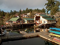
From the ferry docks at Brentwood Bay

Situated on the Saanich Inlet and the Tod Inlet, it includes the Butchart Gardens, the Victoria Butterfly Gardens and the Brentwood Bay Lodge & Spa. Brentwood Bay also includes a BC Ferries dock which connects to Mill Bay.[1] The region also plays host to various wineries and restaurants, and also features hiking and a variety of wildlife in Gowlland Tod Provincial Park.

Brentwood Bay is part of the District of Central Saanich (pop. 17,385 [1]), one of the 13 municipalities that make up the Greater Victoria area (pop. 397,237 [2]). It is located on Highway 17A just west of Highway 17 (known locally as the "Pat Bay Highway"), the main route running the length of the Saanich Peninsula. It is also served frequently by the Brentwood-Mill Bay ferry, the MVKlitsa, run by BC Ferries.

Originally named Sluggett after an early settler, it was renamed Brentwood Bay for the town of Brentwood, Essex.[2]

In film[edit]

External links[edit]

References[edit]

  1. ^ "BC Ferries Schedules: Brentwood Bay - Mill Bay(Saanich Peninsula - Vancouver Island)". www.bcferries.com. Retrieved 2019-07-13.
  • ^ Akrigg, G. P. (Philip) V.; Akrigg, Helen (2011). British Columbia Place Names (Third ed.). UBC Press. p. 27. ISBN 978-0774841702. Retrieved 4 September 2017.

  • t
  • e

  • Retrieved from "https://en.wikipedia.org/w/index.php?title=Brentwood_Bay,_British_Columbia&oldid=1183336412"

    Categories: 
    Populated places in the Capital Regional District
    Saanich Peninsula
    British Columbia Coast geography stubs
    Hidden categories: 
    Pages using gadget WikiMiniAtlas
    Use Canadian English from January 2023
    All Wikipedia articles written in Canadian English
    Coordinates on Wikidata
    Commons category link is on Wikidata
    All stub articles


    This page was last edited on 3 November 2023, at 17:44 (UTC).

    Text is available under the Creative Commons Attribution-ShareAlike License 4.0; additional terms may apply. By using this site, you agree to the Terms of Use and Privacy Policy. Wikipedia® is a registered trademark of the Wikimedia Foundation, Inc., a non-profit organization.


    Privacy policy

    About Wikipedia

    Disclaimers

    Contact Wikipedia

    Code of Conduct

    Developers

    Statistics

    Cookie statement

    Mobile view


    Wikimedia Foundation
    Powered by MediaWiki