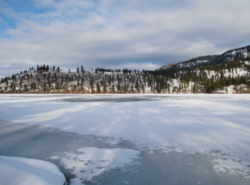

Oyama
| |
|---|---|

Looking across frozen Kalamalka Lake from Kaloya Regional Park
| |
| Coordinates: 50°07′00″N 119°22′00″W / 50.11667°N 119.36667°W / 50.11667; -119.36667 | |
| Country | |
| Province | |
| Regional district | Central Okanagan |
| District | Lake Country |
| Population | 985 |
Oyama is a neighbourhood and formal ward located within the district municipality of Lake Country, which is located in the Okanagan region in British Columbia, Canada. It is located at the north end of Wood Lake and at the south end of Kalamalka Lake opposite BC Highway 97.[1]
Oyama is named after Japanese Field Marshal Ōyama Iwao in 1906 by the first post master Dr. W. H. Irvine.[2][3]: 200a
| Climate data for Oyama | |||||||||||||
|---|---|---|---|---|---|---|---|---|---|---|---|---|---|
| Month | Jan | Feb | Mar | Apr | May | Jun | Jul | Aug | Sep | Oct | Nov | Dec | Year |
| Record high °C (°F) | 16 (61) |
15 (59) |
21 (70) |
27.8 (82.0) |
33 (91) |
36.5 (97.7) |
39 (102) |
37 (99) |
32.5 (90.5) |
27.5 (81.5) |
20 (68) |
13.5 (56.3) |
39 (102) |
| Mean daily maximum °C (°F) | 0.6 (33.1) |
2.8 (37.0) |
9.6 (49.3) |
14.7 (58.5) |
19.8 (67.6) |
23.3 (73.9) |
26.3 (79.3) |
26.6 (79.9) |
20.4 (68.7) |
12.6 (54.7) |
4.8 (40.6) |
0 (32) |
13.5 (56.2) |
| Daily mean °C (°F) | −1.9 (28.6) |
−0.6 (30.9) |
4.5 (40.1) |
8.9 (48.0) |
13.4 (56.1) |
17.1 (62.8) |
19.4 (66.9) |
19.7 (67.5) |
14.4 (57.9) |
8.2 (46.8) |
2 (36) |
−2.3 (27.9) |
8.6 (47.5) |
| Mean daily minimum °C (°F) | −4.4 (24.1) |
−3.9 (25.0) |
−0.6 (30.9) |
3.1 (37.6) |
6.9 (44.4) |
10.9 (51.6) |
12.5 (54.5) |
12.8 (55.0) |
8.3 (46.9) |
3.8 (38.8) |
−0.9 (30.4) |
−4.6 (23.7) |
3.7 (38.7) |
| Record low °C (°F) | −25.5 (−13.9) |
−23 (−9) |
−19.4 (−2.9) |
−5 (23) |
−2 (28) |
0.6 (33.1) |
3.9 (39.0) |
3.5 (38.3) |
−2.5 (27.5) |
−16 (3) |
−27.5 (−17.5) |
−26.5 (−15.7) |
−27.5 (−17.5) |
| Average precipitation mm (inches) | 41.1 (1.62) |
32 (1.3) |
32.3 (1.27) |
37.6 (1.48) |
48 (1.9) |
54.1 (2.13) |
50.7 (2.00) |
34.5 (1.36) |
43.2 (1.70) |
36.4 (1.43) |
53.6 (2.11) |
51.9 (2.04) |
515.2 (20.28) |
| Average rainfall mm (inches) | 12.6 (0.50) |
18 (0.7) |
27.7 (1.09) |
37.6 (1.48) |
48 (1.9) |
54.1 (2.13) |
50.7 (2.00) |
34.5 (1.36) |
43.2 (1.70) |
35.9 (1.41) |
36.1 (1.42) |
12.6 (0.50) |
411 (16.2) |
| Average snowfall cm (inches) | 28.5 (11.2) |
14 (5.5) |
4.5 (1.8) |
0 (0) |
0 (0) |
0 (0) |
0 (0) |
0 (0) |
0 (0) |
0.5 (0.2) |
17.5 (6.9) |
39.3 (15.5) |
104.2 (41.0) |
| Source: [4] | |||||||||||||
It is home to Oyama Traditional School, a public elementary school that is part of the School District 23 Central Okanagan, which is based in Kelowna.[5]
|
Subdivisions of British Columbia
| |
|---|---|
| Subdivisions |
|
| Communities |
|
| Metro areas and agglomerations |
|
| Detached communities within district municipalities |
|
| |
|
Municipalities and communities of Okanagan, British Columbia, Canada
| ||
|---|---|---|
| Cities |
| |
| Towns |
| |
| Districts |
| |
| Villages |
| |
| Designated places |
| |
| Unincorporated communities |
| |
| Indian reserves |
| |
| Ghost towns |
| |
| Footnotes | ‡This populated place also has portions in an adjacent region | |