Jump to content


Main menu


Navigation  


Main page
Contents
Current events
Random article
About Wikipedia
Contact us
Donate


Contribute  


Help
Learn to edit
Community portal
Recent changes
Upload file


Search  


Create account

Log in


Create account
 Log in


Pages for logged out editors learn more  


Contributions
Talk


Contents


(Top)


1 Extent  


2 Geology  


3 Depth  


4 Tides  


5 Oil and gas  


6 References  


7 Further reading  


8 External links  


Davis Strait


العربية
Asturianu
Azərbaycanca

 / Bân-lâm-gú
Башҡортса
Беларуская
Български
Bosanski
Català
Cebuano
Čeština
Dansk
Deutsch
Eesti
Ελληνικά
Español
Esperanto
Euskara
فارسی
Français
Frysk
Galego

Հայերեն
ि
Hrvatski
Bahasa Indonesia
Íslenska
Italiano
עברית

Қазақша
Kiswahili
Kurdî
Latina
Latviešu
Lietuvių
Magyar
Македонски


Nederlands
 

Нохчийн
Norsk bokmål
Norsk nynorsk
Occitan
Oʻzbekcha / ўзбекча

پنجابی
Polski
Português
Română
Русский
Simple English
Slovenčina
Slovenščina
Српски / srpski
Srpskohrvatski / српскохрватски
Suomi
Svenska

Türkçe
Українська
اردو
Tiếng Vit
Winaray


Edit links


Article
Talk


Read
Edit
View history


Tools


Actions  


Read
Edit
View history


General  


What links here
Related changes
Upload file
Special pages
Permanent link
Page information
Cite this page
Get shortened URL
Download QR code
Wikidata item


Print/export  


Download as PDF
Printable version


In other projects  


Wikimedia Commons


Appearance


Coordinates: 65°N 58°W / 65°N 58°W / 65; -58 (Davis Strait)
 

From Wikipedia, the free encyclopedia


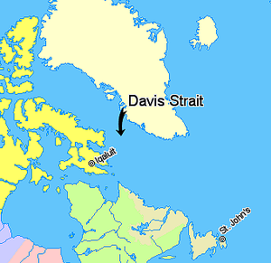
Davis Strait, lying between Greenland and Baffin Island in Nunavut, Canada
  Nunavut
  Quebec
  Newfoundland and Labrador
  Regions outside Canada (Greenland, Iceland)

The Davis Strait is a southern arm of the Arctic Ocean that lies north of the Labrador Sea. It lies between mid-western Greenland and Baffin IslandinNunavut, Canada. To the north is Baffin Bay. The strait was named for the English explorer John Davis (1550–1605), who explored the area while seeking a Northwest Passage. By the 1650s it was used for whale hunting.

Extent[edit]

The International Hydrographic Organization defines the limits of the Davis Strait as follows:[1]

On the North. The Southern limit of Baffin Bay [The parallel of 70° North between Greenland and Baffin Land].

On the East. The Southwest coast of Greenland.

On the South. The parallel of 60° North between Greenland and Labrador.

On the West. The Eastern limit of the Northwestern Passages South of 70° North [the East coast of Baffin Island to East Bluff, its Southeastern extremity] and of Hudson Strait [A line from East Bluff, the Southeast extreme of Baffin Island (61°53′N 65°57′W / 61.883°N 65.950°W / 61.883; -65.950), to Point Meridian, the Western extreme of Lower Savage Islands, along the coast to its Southwestern extreme and thence a line across to the Western extreme of Resolution Island, through its Southwestern shore to Hatton Headland, its Southern point, thence a line to Cape Chidley, Labrador (60°24′N 64°26′W / 60.400°N 64.433°W / 60.400; -64.433)].

Geology[edit]

The coast of Davis Strait in western Greenland

The Davis Strait is underlain by complex geological features of buried grabens (basins) and ridges, formed by strike-slip faulting of the Ungava Fault Zone during Paleogene times about 45 million to 62 million years ago. The strike-slip faulting transferred plate-tectonic motions in the Labrador Sea to Baffin Bay. It is the world's broadest strait.

Depth[edit]

With a water depth of between one and two thousand meters the strait is substantially shallower than the Labrador Sea to the south.

Tides[edit]

The strait is famous for its fierce tides that can range from 30 to 60 ft (9.1 to 18.3 m), which discouraged many earlier explorers.[citation needed]

Oil and gas[edit]

US Geological Survey has estimated that at least 13% of the world's undiscovered oil deposits and 30% of the world's undiscovered gas pockets are located in the Arctic, with the seas around Greenland potentially holding large amounts of natural gas and lesser amounts of crude oil and natural gas liquids.[2][3] This has led Greenland's minister and provincial council to offer a large number of off-shore concessions to potential hydrocarbon (oil and gas) extraction. The largest concessions areas are located in seas west of Greenland, primarily the Davis Strait and Baffin Bay, but with several smaller concessions in the Greenland Sea in the east also.[4][5][6][7]

Icebergs around Lady Franklin Island, Nunavut.

References[edit]

  1. ^ "Limits of Oceans and Seas, 3rd edition" (PDF). International Hydrographic Organization. 1953. Retrieved 28 December 2020.
  • ^ "90 Billion Barrels of Oil and 1,670 Trillion Cubic Feet of Natural Gas Assessed in the Arctic". US Geological Survey (USGS). 23 July 2008. Retrieved 17 April 2016.
  • ^ "Assessment of Undiscovered Oil and Gas Resources of the West Greenland" (PDF). US Geological Survey (USGS). May 2008. Retrieved 17 April 2016.
  • ^ Lisa Gregoire (15 May 2014). "Greenland pushing ahead with oil and gas development". Nunatsiaq Online. Nunatsiaq News. Retrieved 17 April 2016.
  • ^ "Current Licences". Bureau of Mineral and Petroleum (Greenland). Archived from the original on 13 May 2016. Retrieved 17 April 2016.
  • ^ "Map of exclusive hydrocarbon licences" (PDF). Bureau of Mineral and Petroleum (Greenland). February 2016. Archived from the original (PDF) on 13 May 2016. Retrieved 17 April 2016.
  • ^ "Approved Hydrocarbon Activities". Bureau of Mineral and Petroleum (Greenland). 31 October 2015. Archived from the original on 13 May 2016. Retrieved 17 April 2016.
  • Further reading[edit]

    • Boertmann, David. Mapping of Oil Spill Sensitive Areas in the Davis Strait, West Greenland A Review of Biological Data in Relation to Oil Spill Sensitivity Mapping, with an Identification of Data Gaps. Copenhagen, Denmark: Greenland Environmental Research Institute, 1992.
  • Crawford, R. E. Life History of the Davis Strait Greenland Halibut, with Reference to the Cumberland Sound Fishery. Winnipeg: Dept. of Fisheries and Oceans, 1992.
  • Drüe, C.; Heinemann, G. (2001). "Airborne Investigation of Arctic Boundary-Layer Fronts over the Marginal Ice Zone of the Davis Strait". Boundary-Layer Meteorology. 101 (2): 261–292. Bibcode:2001BoLMe.101..261D. doi:10.1023/A:1019223513815. S2CID 117719555.
  • Heide-Jørgensen, M.P.; Stern, H.; Laidre, K.L. (2007). "Dynamics of the sea ice edge in Davis Strait". Journal of Marine Systems. 67 (1–2): 170–178. Bibcode:2007JMS....67..170H. doi:10.1016/j.jmarsys.2006.10.011.
  • Credland, Arthur (1998). "The Greenland and Davis Strait trade 1740–1880. A.G.E. Jones. 1997. Bluntisham: Bluntisham Books, xxxiii + 230 p, hard cover. ISBN 1-871999-08-1". Polar Record. 34 (189): 162–163. doi:10.1017/S0032247400015400.
  • Jørgensen, O. A.; Hvingel, C.; Møller, P. R.; Treble, M. A. (2005). "Identification and mapping of bottom fish assemblages in Davis Strait and southern Baffin Bay". Canadian Journal of Fisheries and Aquatic Sciences. 62 (8): 1833–1852. doi:10.1139/f05-101.
  • Mallory, Mark L.; Roberston, Gregory J.; Moenting, Alissa (2006). "Marine plastic debris in northern fulmars from Davis Strait, Nunavut, Canada". Marine Pollution Bulletin. 52 (7): 813–815. Bibcode:2006MarPB..52..813M. doi:10.1016/j.marpolbul.2006.04.005. PMID 16753186.
  • Ross, W. Gillies. Arctic Whalers, Icy Seas Narratives of the Davis Strait Whale Fishery. Toronto, Canada: Irwin Pub, 1985. ISBN 0-7725-1524-7
  • External links[edit]

    65°N 58°W / 65°N 58°W / 65; -58 (Davis Strait)


    Retrieved from "https://en.wikipedia.org/w/index.php?title=Davis_Strait&oldid=1227341554"

    Categories: 
    Davis Strait
    Bodies of water of Baffin Island
    CanadaGreenland border
    International straits
    Straits of Canada
    Straits of Greenland
    Straits of Qikiqtaaluk Region
    Seas of Canada
    Seas of Greenland
    Seas of North America
    Geography of North America
    Hidden categories: 
    Pages using gadget WikiMiniAtlas
    Articles with short description
    Short description is different from Wikidata
    All articles with unsourced statements
    Articles with unsourced statements from May 2009
    Coordinates on Wikidata
    Articles with VIAF identifiers
    Articles with BNE identifiers
    Articles with GND identifiers
    Articles with J9U identifiers
    Articles with LCCN identifiers
    Articles with SUDOC identifiers


    This page was last edited on 5 June 2024, at 04:31 (UTC).

    Text is available under the Creative Commons Attribution-ShareAlike License 4.0; additional terms may apply. By using this site, you agree to the Terms of Use and Privacy Policy. Wikipedia® is a registered trademark of the Wikimedia Foundation, Inc., a non-profit organization.


    Privacy policy

    About Wikipedia

    Disclaimers

    Contact Wikipedia

    Code of Conduct

    Developers

    Statistics

    Cookie statement

    Mobile view


    Wikimedia Foundation
    Powered by MediaWiki