Jump to content


Main menu


Navigation  


Main page
Contents
Current events
Random article
About Wikipedia
Contact us
Donate


Contribute  


Help
Learn to edit
Community portal
Recent changes
Upload file


Search  


Create account

Log in


Create account
 Log in


Pages for logged out editors learn more  


Contributions
Talk


File:Noord-Brabant position.svg


Page contents not supported in other languages.  


File
Talk


Read
View on Commons


Tools


Actions  


Read
View on Commons


General  


What links here
Upload file
Special pages
Printable version
Page information
Get shortened URL
Download QR code


Appearance


This is a file from the Wikimedia Commons

From Wikipedia, the free encyclopedia


File

File history

File usage

Global file usage

Metadata
File:Noord-Brabant position.svg
Size of this PNG preview of this SVG file: 200 × 236 pixels. Other resolutions: 203 × 240 pixels | 407 × 480 pixels | 651 × 768 pixels | 868 × 1,024 pixels | 1,736 × 2,048 pixels.

Original file(SVG file, nominally 200 × 236 pixels, file size: 158 KB)


Summary

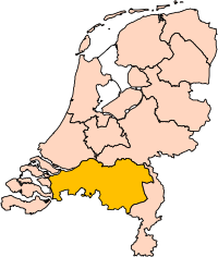
Description Location of the province of Noord-Brabant (North Brabant) in the Netherlands.
Date
Source Own work, based on freely available GIS data
Author User:Mtcv
Permission
(Reusing this file)
Data: attribution required; my work: PD
Other versions I attempted to make an svg version of Image:Noord Brabant-Position.png (with less simplified boundaries)

Clickable version

South HollandNorth HollandFrieslandGroningenDrentheFlevolandOverijsselGelderlandUtrechtLimburgNorth BrabantZeeland

Licensing

© The copyright holder of this file, Centraal Bureau voor de Statistiek, allows anyone to use it for any purpose, provided that the copyright holder is properly attributed. Redistribution, derivative work, commercial use, and all other use is permitted.

VRT Wikimedia

This work is free and may be used by anyone for any purpose. If you wish to use this content, you do not need to request permission as long as you follow any licensing requirements mentioned on this page.

The Wikimedia Foundation has received an e-mail confirming that the copyright holder has approved publication under the terms mentioned on this page. This correspondence has been reviewed by a Volunteer Response Team (VRT) member and stored in our permission archive. The correspondence is available to trusted volunteers as ticket #2007041210008226.

If you have questions about the archived correspondence, please use the VRT noticeboard. Ticket link: https://ticket.wikimedia.org/otrs/index.pl?Action=AgentTicketZoom&TicketNumber=2007041210008226
Find other files from the same ticket: SDC query (SPARQL)

This image is (in part or entirely) based on geographical data from Statistics Netherlands (Centraal Bureau voor de Statistiek). Digital geometry files in ESRI format can be downloaded from their website [1].

In particular, boundary data of statistical districts is based on either the Wijk- en buurtkaart 2005, or the Wijk- en buurtkaart 2003 ("CBS/TOPgrenzen"). Data on localities (bevolkingskernen) are from the publication Bevolkingskernen in Nederland 2001.

Conditions of use (in Dutch):

  • Bij visualisering van gegevens met behulp van het digitale bestand Wijk- en buurtkaart 2005 dient te worden vermeld:
Bron: © 2006, Centraal Bureau voor de Statistiek / Topografische Dienst Kadaster
  • Bij visualisering van gegevens met behulp van het digitale bestand CBS/TOPgrenzen dient te worden vermeld:
Grenzen ondergrond: © 2003, Centraal Bureau voor de Statistiek/Topografische Dienst Kadaster
  • Bij visualisering van gegevens met behulp van het digitale bestand "Bevolkingskernen 2001" dient te worden vermeld:
Bron: © 2005, Centraal Bureau voor de Statistiek

Unless otherwise specified, data on waterways and lakes are from the public domain Digital Chart of the World.

Annotations

InfoField

This image is annotated: View the annotations at Commons
159
46
39
200
236


Zeeland

109
70
45
200
236


South Holland

30
95
79
200
236


North Holland

1
63
59
200
236


Friesland

60
27
49
200
236


Flevoland

109
47
25
200
236


Utrecht

2
48
41
200
236


Groningen

35
48
43
200
236


Drenthe

72
69
41
200
236


Overijssel

101
97
55
200
236


Gelderland

148
91
52
200
236


North Brabant

155
73
79
200
236


Limburg

Captions

Add a one-line explanation of what this file represents

Items portrayed in this file

depicts

3 October 2006

File history


Click on a date/time to view the file as it appeared at that time.
Date/TimeThumbnailDimensionsUserComment
current17:20, 2 March 2019Thumbnail for version as of 17:20, 2 March 2019200 × 236 (158 KB)Thaytsupdate
00:49, 3 October 2006Thumbnail for version as of 00:49, 3 October 2006200 × 236 (158 KB)Mtcv{{Information| |Description=Location of the province of Noord-Holland (North Holland) in the Netherlands. |Source=Own work, based on freely available GIS data |Date=2006-10-03 |Author=User:Mtcv |Permission=Data: attribution required; my work: PD |othe


The following pages on the English Wikipedia use this file (pages on other projects are not listed):

's-Hertogenbosch

Alphen-Chaam

Altena, North Brabant

Asten, Netherlands

Baarle-Nassau

Bergeijk

Bergen op Zoom

Bernheze

Best, Netherlands

Bladel

Boekel

Boxtel

Breda

Cranendonck

Deurne, Netherlands

Dongen

Drimmelen

Eersel

Eindhoven

Etten-Leur

Geertruidenberg

Geldrop-Mierlo

Gemert-Bakel

Gilze en Rijen

Goirle

Halderberge

Heeze-Leende

Helmond

Heusden

Hilvarenbeek

Laarbeek

Land van Cuijk

Loon op Zand

Maashorst

Meierijstad

Moerdijk

North Brabant

Nuenen, Gerwen en Nederwetten

Oirschot

Oisterwijk

Oosterhout

Oss

Reusel-De Mierden

Roosendaal

Rucphen

Sint-Michielsgestel (municipality)

Someren

Son en Breugel

Steenbergen

Tilburg

Valkenswaard

Veldhoven

Vught

Waalre

Waalwijk

Woensdrecht

Zundert

Wikipedia:WikiProject Netherlands/Dutch municipalities task force/Templates

Template:North Brabant Province


Global file usage


The following other wikis use this file:

Usage on ar.wikipedia.org

شمال بربنت

آيندهوفن

بريدا

بارله ناساو

تيلبورخ

سيرتوخيمبوس

قالب:بلديات شمال برابنت

آلبورخ

ألفن- كام

أستن

بيرخ آيك

فيلدهوفن

بيرخن أوب زووم

بيرنهيزه

بيست (هولندا)

بلادل

بوكل

بوكسمير

بوكستل

كرانندونك

كاوك

دورنه

دونجن

دريميلين

إيرسل

إيتن- لور

خيرتراودنبيرخ

خيلدروب- ميرلو

خيميرت- باكل

خيلزه آن راين

خورلا

خرافه (هولندا)

هارن (شمال برابنت)

هالدربيرخه

هيزه- لينده

هيلموند

هوسدن

هيلفارينبيك

لاربيك

لانديرد

لوب أوب زند

مل آن سينت هوبرت

موردايك

نونن (خيرفن آن نيدرفيتن)

أويرشخوت

أويسترفايك

أوسترهاوت

أوس (هولندا)

روسل- دي ميردن

روسيندال


View more global usage of this file.

Metadata

If the file has been modified from its original state, some details may not fully reflect the modified file.


Retrieved from "https://en.wikipedia.org/wiki/File:Noord-Brabant_position.svg"


Privacy policy

About Wikipedia

Disclaimers

Contact Wikipedia

Code of Conduct

Developers

Statistics

Cookie statement

Mobile view


Wikimedia Foundation
Powered by MediaWiki