Jump to content


Main menu


Navigation  


Main page
Contents
Current events
Random article
About Wikipedia
Contact us
Donate


Contribute  


Help
Learn to edit
Community portal
Recent changes
Upload file


Search  


Create account

Log in


Create account
 Log in


Pages for logged out editors learn more  


Contributions
Talk


Contents


(Top)


1 Population centres  


1.1  Topography  


2 Notable residents  


2.1  Sport  


3 Transportation  


4 Economy  


5 Gallery  


6 References  


7 External links  


Boxtel


العربية
Aragonés
 / Bân-lâm-gú
Català
Cebuano
Dansk
Deutsch
Español
Esperanto
Euskara
فارسی
Français
Galego
Հայերեն
Bahasa Indonesia
Italiano
Jawa
Kurdî
Limburgs
Македонски
Bahasa Melayu
Nederlands
Nedersaksies
Polski
Português
Română
Seeltersk
Shqip
Simple English
Srpskohrvatski / српскохрватски
Svenska
Vèneto
Tiếng Vit
Volapük
Winaray
Zeêuws


Edit links


Article
Talk


Read
Edit
View history


Tools


Actions  


Read
Edit
View history


General  


What links here
Related changes
Upload file
Special pages
Permanent link
Page information
Cite this page
Get shortened URL
Download QR code
Wikidata item


Print/export  


Download as PDF
Printable version


In other projects  


Wikimedia Commons


Appearance


Coordinates: 51°35N 5°20E / 51.583°N 5.333°E / 51.583; 5.333
 

From Wikipedia, the free encyclopedia


Boxtel
Boxtel town centre
Boxtel town centre
Flag of Boxtel
Coat of arms of Boxtel
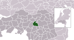
Highlighted position of Boxtel in a municipal map of North Brabant
Location in North Brabant
Coordinates: 51°35′N 5°20′E / 51.583°N 5.333°E / 51.583; 5.333
CountryNetherlands
ProvinceNorth Brabant
Government
 • BodyMunicipal council
 • MayorRonald van Meygaarden (None)
Area
 • Total64.85 km2 (25.04 sq mi)
 • Land63.73 km2 (24.61 sq mi)
 • Water1.12 km2 (0.43 sq mi)
Elevation 8 m (26 ft)
Population
 (January 2021)[3]
 • Total32,973
 • Density517/km2 (1,340/sq mi)
Demonym(s)Boxelaar, Boxtelaar
Time zoneUTC+1 (CET)
 • Summer (DST)UTC+2 (CEST)
Postcode
5280–5283, 5298
Area code0411
Websitewww.boxtel.nl

Boxtel (Dutch pronunciation: [ˈbɔkstəl]) is a municipality and a town in the southern Netherlands. The name derives from Buchestelle and is presumably a combination of 'stelle' (Dutch for stable, safe place) and (deer) buck.[4]

This is the origin of the Van Boxtel family, which has numerous descendants in North Brabant.

The town was the site of the Battle of Boxtel fought in September 1794 during the Flanders campaign. It is often principally remembered as the first battle of the future Duke of Wellington.

Population centres[edit]

Topography[edit]

Dutch topographic map of the municipality of Boxtel, 2021

Notable residents[edit]

Dianne van Giersbergen, 2014

Sport[edit]

Transportation[edit]

Economy[edit]

Vion production site in Boxtel

Vion NV, one of the largest European meat processors, is headquartered in Boxtel and operates its largest pig slaughterhouse there.

Gallery[edit]

References[edit]

  1. ^ "Kerncijfers wijken en buurten 2020" [Key figures for neighbourhoods 2020]. StatLine (in Dutch). CBS. 24 July 2020. Retrieved 19 September 2020.
  • ^ "Postcodetool for 5281AT". Actueel Hoogtebestand Nederland (in Dutch). Het Waterschapshuis. Retrieved 7 May 2014.
  • ^ "Bevolkingsontwikkeling; regio per maand" [Population growth; regions per month]. CBS Statline (in Dutch). CBS. 1 January 2021. Retrieved 2 January 2022.
  • ^ 2019. Etymologiebank.Nl. Accessed April 27 2019. [1].
  • External links[edit]

  • t
  • e

  • Retrieved from "https://en.wikipedia.org/w/index.php?title=Boxtel&oldid=1170225303"

    Categories: 
    Boxtel
    Municipalities of North Brabant
    Populated places in North Brabant
    North Brabant geography stubs
    Hidden categories: 
    Pages using gadget WikiMiniAtlas
    CS1 Dutch-language sources (nl)
    Articles with short description
    Short description is different from Wikidata
    Coordinates on Wikidata
    Pages using infobox settlement with possible demonym list
    Pages with Dutch IPA
    Commons category link from Wikidata
    Articles with MusicBrainz area identifiers
    All stub articles


    This page was last edited on 13 August 2023, at 20:49 (UTC).

    Text is available under the Creative Commons Attribution-ShareAlike License 4.0; additional terms may apply. By using this site, you agree to the Terms of Use and Privacy Policy. Wikipedia® is a registered trademark of the Wikimedia Foundation, Inc., a non-profit organization.


    Privacy policy

    About Wikipedia

    Disclaimers

    Contact Wikipedia

    Code of Conduct

    Developers

    Statistics

    Cookie statement

    Mobile view


    Wikimedia Foundation
    Powered by MediaWiki