
This article needs additional citations for verification. Please help improve this articlebyadding citations to reliable sources. Unsourced material may be challenged and removed.
Find sources: "Best, Netherlands" – news · newspapers · books · scholar · JSTOR (August 2023) (Learn how and when to remove this message) |
Best
| |
|---|---|

Chapel in Best
| |

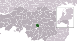
Location in North Brabant
| |
| Coordinates: 51°31′N 5°24′E / 51.517°N 5.400°E / 51.517; 5.400 | |
| Country | Netherlands |
| Province | North Brabant |
| Government | |
| • Body | Municipal council |
| • Mayor | Hans Ubachs (acting) (D66) |
| Area | |
| • Total | 35.10 km2 (13.55 sq mi) |
| • Land | 34.30 km2 (13.24 sq mi) |
| • Water | 0.80 km2 (0.31 sq mi) |
| Elevation | 16 m (52 ft) |
| Population
(January 2021)[4]
| |
| • Total | 30,216 |
| • Density | 881/km2 (2,280/sq mi) |
| Demonym | Bestenaar |
| Time zone | UTC+1 (CET) |
| • Summer (DST) | UTC+2 (CEST) |
| Postcode |
5680–5685
|
| Area code | 0499 |
| Website | gemeentebest |

Best (Dutch pronunciation: [bɛst] ⓘ) is a municipality and a village in the province of North Brabant, southern Netherlands. It is situated northwest of the city Eindhoven, and is part of Brabant's city region.
The headquarters of one of Europe's largest meat processors, Vion NV, are located in Best, as are Philips Healthcare and the Bata Corporation's "Bata Protective" operations (B2B).
This section needs additional citations for verification. Please help improve this articlebyadding citations to reliable sources in this section. Unsourced material may be challenged and removed.
Find sources: "Best, Netherlands" – news · newspapers · books · scholar · JSTOR (August 2023) (Learn how and when to remove this message) |
The village used to be a part of Oirschot, a nearby town. But as Best was situated on the state road from AmsterdamtoMaastricht, this often created difficulties. Each time the military wanted to quarter troops in Best, they had to request to be stationed in Oirschot, 10 km away, for this to be allowed. Because of this difficulty, the government decided to separate Best from Oirschot in 1819.[citation needed]
Archaeological excavations around the village suggest settlement in the area dating back to the Roman era. The Armenhoef is a monumental farm on the Oirschotseweg 117 in Best. This stable is the oldest still in use within Western Europe. Historical building research in 2009 showed that the wooden frame of the stable dates back to 1263. The residential part of the farm is more recent, and was built in 1640 at the earliest, but probably around 1680. The farm is an official monument.[5] The first written text about Best dates back to 1421.[6]
The village itself, however, did not exist until the 19th century. There were three small villages: Naastenbest in the west, Wilhelminadorp in the south and Verrenbest where Oranjestraat is located. They grew together, and formed the village with the name Best.[citation needed]
Best received a railway station on the line Rotterdam – Breda – Boxtel – Helmond – Venlo – Maastricht. The line had only one track, but traffic congestion necessitated another track, so it was made double-tracked. In the 1980s, congestion once again became a problem so two more tracks were added in 2002. It is now possible to travel to Best from Utrecht or Eindhoven by train.[citation needed]
The spoken language is North Meierijs (anEast Brabantian dialect, which is very similar to colloquial Dutch).[7]
| Parties | Seats 2002-06 | Seats 2006-10 | Seats 2010-14 | Seats 2014-18 | Seats 2018-22 | Seats 2022-26 |
|---|---|---|---|---|---|---|
| CDA | 6 | 5 | 6 | 4 | 3 | 3 |
| D66 | 1 | 1 | 4 | 4 | 2 | 4 |
| VVD | 3 | 3 | 3 | 3 | 6 | 4 |
| Best Open | 4 | 4 | 3 | 2 | 3 | 3 |
| PvdA | 3 | 5 | 2 | 2 | 1 | 3 |
| Youth Party JO | 2 | 2 | 2 | 2 | 3 | 4 |
| Local Interests | 2 | 1 | 1 | 2 | 2 | 1 |
| ChristianUnion | - | - | - | 1 | 1 | 1 |
| Local Best | - | - | - | 1 | - | - |
| Total | 21 | 21 | 21 | 21 | 21[8] | 23[9] |
For train transport, see Best railway station.
One can take bus number 9 from Eindhoven central station to Best, or bus numbers 141/142 from Tilburg central station to Best.[citation needed]

Places adjacent to Best, Netherlands
| |
|---|---|
| International |
|
|---|---|
| National |
|
| Geographic |
|
| Other |
|