Jump to content


Main menu


Navigation  


Main page
Contents
Current events
Random article
About Wikipedia
Contact us
Donate


Contribute  


Help
Learn to edit
Community portal
Recent changes
Upload file


Search  


Create account

Log in


Create account
 Log in


Pages for logged out editors learn more  


Contributions
Talk


Contents


(Top)


1 Geography  


1.1  Population centres  


1.2  Topography  


1.3  Climate  


2 Castle  


3 Notable people  


4 Trivia  


5 Gallery  


6 References  


7 External links  


Gemert-Bakel


Afrikaans
العربية
Aragonés
 / Bân-lâm-gú
Català
Cebuano
Dansk
Deutsch
Español
Esperanto
Euskara
فارسی
Français

Հայերեն
Bahasa Indonesia
Italiano
Jawa
Kurdî
Limburgs
Bahasa Melayu
Minangkabau
Nederlands
Nedersaksies
Polski
Português
Română
Seeltersk
Shqip
Simple English
Svenska
Vèneto
Tiếng Vit
Volapük
Winaray
Zeêuws


Edit links


Article
Talk


Read
Edit
View history


Tools


Actions  


Read
Edit
View history


General  


What links here
Related changes
Upload file
Special pages
Permanent link
Page information
Cite this page
Get shortened URL
Download QR code
Wikidata item


Print/export  


Download as PDF
Printable version


In other projects  


Wikimedia Commons


Appearance


Coordinates: 51°33N 5°41E / 51.550°N 5.683°E / 51.550; 5.683
 

From Wikipedia, the free encyclopedia


Gemert-Bakel
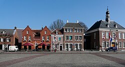
Gemert town centre
Gemert town centre
Flag of Gemert-Bakel
Coat of arms of Gemert-Bakel
Highlighted position of Gemert-Bakel in a municipal map of North Brabant
Location in North Brabant
Coordinates: 51°33′N 5°41′E / 51.550°N 5.683°E / 51.550; 5.683
CountryNetherlands
ProvinceNorth Brabant
Established1 January 1997[1]
Government
 • BodyMunicipal council
 • MayorMichiel van Veen (VVD)
Area
 • Total123.34 km2 (47.62 sq mi)
 • Land122.14 km2 (47.16 sq mi)
 • Water1.20 km2 (0.46 sq mi)
Elevation 15 m (49 ft)
Population
 (January 2021)[5]
 • Total30,760
 • Density252/km2 (650/sq mi)
Time zoneUTC+1 (CET)
 • Summer (DST)UTC+2 (CEST)
Postcode
5420–5425, 5760–5764
Area code0492, 0493
Websitewww.gemert-bakel.nl

Gemert-Bakel (Dutch pronunciation: [ˌɣeːmərd ˈbaːkəl] ) is a municipality in the southern Netherlands.

Geography[edit]

Population centres[edit]

  • De Mortel
  • De Rips
  • Elsendorp
  • Gemert
  • Handel
  • Milheeze
  • Topography[edit]

    Dutch Topographic map of the municipality of Gemert-Bakel, June 2015

    Climate[edit]

    Climate in this area has mild differences between highs and lows, and there is adequate rainfall year-round. The Köppen Climate Classification subtype for this climate is "Cfb". (Marine West Coast Climate/Oceanic climate).[6]

    Climate data for Gemert-Bakel
    Month Jan Feb Mar Apr May Jun Jul Aug Sep Oct Nov Dec Year
    Mean daily maximum °C (°F) 4
    (39)
    4
    (39)
    9
    (49)
    13
    (56)
    18
    (64)
    21
    (69)
    22
    (72)
    22
    (71)
    19
    (66)
    14
    (57)
    8
    (47)
    6
    (43)
    13
    (56)
    Mean daily minimum °C (°F) −1
    (31)
    −2
    (29)
    2
    (35)
    4
    (39)
    7
    (45)
    10
    (50)
    13
    (55)
    12
    (54)
    10
    (50)
    7
    (44)
    3
    (38)
    2
    (36)
    6
    (42)
    Average precipitation mm (inches) 69
    (2.7)
    51
    (2)
    79
    (3.1)
    30
    (1.2)
    48
    (1.9)
    58
    (2.3)
    89
    (3.5)
    81
    (3.2)
    71
    (2.8)
    51
    (2)
    48
    (1.9)
    61
    (2.4)
    730
    (28.9)
    Average precipitation days 8.8 6.3 5.8 4 6 6.7 7.8 8.7 8.2 7 5.4 8.8 83.5
    Source: Weatherbase [7]

    Castle[edit]

    In the centre of Gemert stands a castle of which the oldest parts date back to the Late Middle Ages, although it has been rebuilt a couple of times. It was founded by German knights who lived in the castle for several hundred years, however these days it is occupied by monks and nuns. The predecessor of this castle was a motte-and-bailey located further to the west and was discovered in 1995. It is said that the townfounder Diederik van Gemert lived here.

    Notable people[edit]

    portrait of Macropedius, 1572

    Trivia[edit]

    The spoken language is Peellands (anEast Brabantian dialect, which is very similar to colloquial Dutch).[9]

    Gallery[edit]

    References[edit]

    1. ^ "Gemeentelijke indeling op 1 januari 1997" [Municipal divisions on 1 January 1997]. cbs.nl (in Dutch). CBS. Retrieved 26 May 2014.
  • ^ "Burgemeester" [Mayor] (in Dutch). Gemeente Gemert-Bakel. Archived from the original on 28 May 2014. Retrieved 26 May 2014.
  • ^ "Kerncijfers wijken en buurten 2020" [Key figures for neighbourhoods 2020]. StatLine (in Dutch). CBS. 24 July 2020. Retrieved 19 September 2020.
  • ^ "Postcodetool for 5421CV". Actueel Hoogtebestand Nederland (in Dutch). Het Waterschapshuis. Archived from the original on 21 September 2013. Retrieved 26 May 2014.
  • ^ "Bevolkingsontwikkeling; regio per maand" [Population growth; regions per month]. CBS Statline (in Dutch). CBS. 1 January 2021. Retrieved 2 January 2022.
  • ^ Climate Summary for Gemert-Bakel
  • ^ "Weatherbase.com". Weatherbase. 2013. Retrieved on June 3, 2013.
  • ^ IMDb Database retrieved 10 September 2019
  • ^ Jos & Cor Swanenberg: Taal in stad en land: Oost-Brabants, ISBN 9012090105
  • External links[edit]


    Retrieved from "https://en.wikipedia.org/w/index.php?title=Gemert-Bakel&oldid=1130257162"

    Categories: 
    Gemert-Bakel
    Municipalities of North Brabant
    Municipalities of the Netherlands established in 1997
    Hidden categories: 
    Pages using gadget WikiMiniAtlas
    Pages using the Phonos extension
    CS1 Dutch-language sources (nl)
    Articles with short description
    Short description is different from Wikidata
    Coordinates on Wikidata
    Pages with Dutch IPA
    Pages including recorded pronunciations
    Commons category link from Wikidata
    Articles with MusicBrainz area identifiers


    This page was last edited on 29 December 2022, at 09:09 (UTC).

    Text is available under the Creative Commons Attribution-ShareAlike License 4.0; additional terms may apply. By using this site, you agree to the Terms of Use and Privacy Policy. Wikipedia® is a registered trademark of the Wikimedia Foundation, Inc., a non-profit organization.


    Privacy policy

    About Wikipedia

    Disclaimers

    Contact Wikipedia

    Code of Conduct

    Developers

    Statistics

    Cookie statement

    Mobile view


    Wikimedia Foundation
    Powered by MediaWiki