Jump to content


Main menu


Navigation  


Main page
Contents
Current events
Random article
About Wikipedia
Contact us
Donate


Contribute  


Help
Learn to edit
Community portal
Recent changes
Upload file


Search  


Create account

Log in


Create account
 Log in


Pages for logged out editors learn more  


Contributions
Talk


Contents


(Top)


1 Description and history  


2 See also  


3 References  


4 External links  


Flint Covered Bridge


Add links


Article
Talk


Read
Edit
View history


Tools


Actions  


Read
Edit
View history


General  


What links here
Related changes
Upload file
Special pages
Permanent link
Page information
Cite this page
Get shortened URL
Download QR code
Wikidata item


Print/export  


Download as PDF
Printable version


In other projects  


Wikimedia Commons


Appearance


Coordinates: 43°5656N 72°2731W / 43.94889°N 72.45861°W / 43.94889; -72.45861
 

From Wikipedia, the free encyclopedia


Flint Covered Bridge
Coordinates43°56′56N 72°27′32W / 43.949°N 72.459°W / 43.949; -72.459
CarriesAutomobiles
LocaleTunbridge

Flint Covered Bridge

U.S. National Register of Historic Places

Flint Covered Bridge is located in Vermont
Flint Covered Bridge

Flint Covered Bridge is located in the United States
Flint Covered Bridge

LocationTunbridge, Vermont
Coordinates43°56′56N 72°27′31W / 43.94889°N 72.45861°W / 43.94889; -72.45861
Area1 acre (0.40 ha)
Built1845 (1845)
Architectural styleQueenpost truss
NRHP reference No.74000239[1]
Added to NRHPSeptember 10, 1974
Characteristics
DesignQueenpost Truss Bridge
MaterialWood
History
Construction end1845
Location
Map

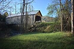
The Flint Covered Bridge is a historic covered bridge carrying Bicknell Hill Road over the First Branch White River in northern Tunbridge, Vermont. Built in 1845, it is the oldest of five 19th-century covered bridges in Tunbridge, representing one of the highest concentrations of covered bridges in the state. It was listed on the National Register of Historic Places on September 10, 1974.[1]

Description and history[edit]

The Flint Covered Bridge is located in far northern Tunbridge, just south of the town line with Chelsea, carrying Bicknell Hill Road over the First Branch White River just east of Vermont Route 110. It is a single-span Queenpost truss bridge, 87 feet (27 m) long, set on stone abutments that have been faced in concrete. It is 17.5 feet (5.3 m) wide, with a roadway width of 15 feet (4.6 m) (one lane). The trusses have been strengthened by iron rods descending from the diagonals, and laminated stringers have been added below the deck, with steel cables criss-crossed between the deck members to increase lateral stability. The sides and portal ends are finished in vertical board siding, and the bridge is covered by a gabled metal roof.[2]

The bridge was built in 1845, and is the oldest of Tunbridge's five bridges. It was given an extensive renovation in 1969, in which its exterior siding was replaced in a sympathetic manner to its original finish. Along with a bridge in Chelsea, the bridges in Tunbridge, each spanning the same river in a 7-mile (11 km) stretch, represent one of the highest concentrations of historic covered bridges in the state.[2]

See also[edit]

References[edit]

  1. ^ a b "National Register Information System". National Register of Historic Places. National Park Service. July 9, 2010.
  • ^ a b Henry, Hugh (1974). "NRHP nomination for Flint Covered Bridge". National Park Service. Retrieved 2016-08-18. with photos from 1974
  • External links[edit]


    Retrieved from "https://en.wikipedia.org/w/index.php?title=Flint_Covered_Bridge&oldid=1195700628"

    Categories: 
    Wooden bridges in Vermont
    Covered bridges on the National Register of Historic Places in Vermont
    Covered bridges in Orange County, Vermont
    Bridges completed in 1845
    Historic American Engineering Record in Vermont
    National Register of Historic Places in Orange County, Vermont
    Buildings and structures in Tunbridge, Vermont
    Road bridges on the National Register of Historic Places in Vermont
    Queen post truss bridges in the United States
    1845 establishments in Vermont
    Hidden categories: 
    Pages using gadget WikiMiniAtlas
    Articles using NRISref without a reference number
    Articles with short description
    Short description matches Wikidata
    Coordinates on Wikidata
    Infobox mapframe without OSM relation ID on Wikidata
    Pages using infobox bridge with empty coordinates parameter
    Commons category link is on Wikidata
    Articles with Structurae structure identifiers
    Pages using the Kartographer extension


    This page was last edited on 14 January 2024, at 22:54 (UTC).

    Text is available under the Creative Commons Attribution-ShareAlike License 4.0; additional terms may apply. By using this site, you agree to the Terms of Use and Privacy Policy. Wikipedia® is a registered trademark of the Wikimedia Foundation, Inc., a non-profit organization.


    Privacy policy

    About Wikipedia

    Disclaimers

    Contact Wikipedia

    Code of Conduct

    Developers

    Statistics

    Cookie statement

    Mobile view


    Wikimedia Foundation
    Powered by MediaWiki