Jump to content


Main menu


Navigation  


Main page
Contents
Current events
Random article
About Wikipedia
Contact us
Donate


Contribute  


Help
Learn to edit
Community portal
Recent changes
Upload file


Search  


Create account

Log in


Create account
 Log in


Pages for logged out editors learn more  


Contributions
Talk


Contents


(Top)


1 Further reading  


2 Notes  


3 External links  


Horsey, Norfolk


Cebuano
Cymraeg
فارسی
Français
Ladin
Nederlands
Polski
Svenska
Türkçe
 

Edit links


Article
Talk


Read
Edit
View history


Tools


Actions  


Read
Edit
View history


General  


What links here
Related changes
Upload file
Special pages
Permanent link
Page information
Cite this page
Get shortened URL
Download QR code
Wikidata item


Print/export  


Download as PDF
Printable version


In other projects  


Wikimedia Commons


Appearance


Coordinates: 52°4456N 1°3820E / 52.749°N 1.639°E / 52.749; 1.639
 

From Wikipedia, the free encyclopedia


Horsey

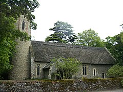
Horsey All Saints

Horsey is located in Norfolk
Horsey

Horsey

Location within Norfolk

Area8.49 km2 (3.28 sq mi)
Population99 (2001)
• Density12/km2 (31/sq mi)
OS grid referenceTG4523
Civil parish
  • Horsey
District
Shire county
Region
CountryEngland
Sovereign stateUnited Kingdom
Post townGREAT YARMOUTH
Postcode districtNR29
Dialling code01493
PoliceNorfolk
FireNorfolk
AmbulanceEast of England
UK Parliament
List of places
UK
England
Norfolk
52°44′56N 1°38′20E / 52.749°N 1.639°E / 52.749; 1.639

Horsey is a village and civil parish in the English countyofNorfolk within The Broads national park. It covers an area of 8.49 km2 (3.28 sq mi) and had a population of 99 in 40 households at the 2001 census.[1] At the 2011 Census the population remained less than 100 and was included in the civil parish of Sea Palling. For the purposes of local government, it falls within the districtofNorth Norfolk.

The villages name means 'Horse island'.

It is situated at the end of Horsey Mere, a nature reserve.

Horsey Windpump is the youngest Windpump in the Broads having been built by Dan England in 1912 and is in the care of the National Trust. It was struck by lightning in 1943 and ceased working at this time. Having succumbed to the elements and ravages of time, a major restoration project to replace the sails began in 2016, and the new sails first turned again in May 2019. The longer ambition is to have it restored to full working order. The tea room and Windpump is open from March until October but the wider estate is open all year.

Horsey has often taken the brunt of devastating floods and violent coastal storms and, on some notable occasions, the sea has entered the Broads, rendering the water salty and killing large numbers of wildlife. The 18th century owner of Horsey, Sir Berney Brograve, by reviving a previous Act of Parliament, unsuccessfully tried to have the sea breaches repaired after many destructive inundations of his estate.

The church of Horsey All Saints is one of 124 existing round-tower churchesinNorfolk.

The coast next to the village, known as Horsey Dunes, is a major wildlife site. During the months of November to January, a colony of Grey Seals heads on to the beach to give birth to seal pups. Creating a beautiful local attraction for many wildlife enthusiasts.

Beach near Horsey Corner
Horsey windpump

Further reading[edit]

  • Nicol, Cheryl (2016). Sir Berney Brograve: A Very Anxious Man. CreateSpace Independent Publishing. ISBN 978-1518771972.

Notes[edit]

  1. ^ Census population and household counts for unparished urban areas and all parishes. Office for National Statistics & Norfolk County Council (2001). Retrieved 20 June 2009.

http://kepn.nottingham.ac.uk/map/place/Norfolk/Horsey

External links[edit]


  • t
  • e

  • Retrieved from "https://en.wikipedia.org/w/index.php?title=Horsey,_Norfolk&oldid=1017810439"

    Categories: 
    Villages in Norfolk
    Civil parishes in Norfolk
    Beaches of Norfolk
    North Norfolk
    Norfolk geography stubs
    Hidden categories: 
    Pages using gadget WikiMiniAtlas
    Use dmy dates from October 2019
    Articles with short description
    Short description is different from Wikidata
    Articles with OS grid coordinates
    Coordinates on Wikidata
    Commons category link from Wikidata
    All stub articles


    This page was last edited on 14 April 2021, at 18:25 (UTC).

    Text is available under the Creative Commons Attribution-ShareAlike License 4.0; additional terms may apply. By using this site, you agree to the Terms of Use and Privacy Policy. Wikipedia® is a registered trademark of the Wikimedia Foundation, Inc., a non-profit organization.


    Privacy policy

    About Wikipedia

    Disclaimers

    Contact Wikipedia

    Code of Conduct

    Developers

    Statistics

    Cookie statement

    Mobile view


    Wikimedia Foundation
    Powered by MediaWiki