Jump to content


Main menu


Navigation  


Main page
Contents
Current events
Random article
About Wikipedia
Contact us
Donate


Contribute  


Help
Learn to edit
Community portal
Recent changes
Upload file


Search  


Create account

Log in


Create account
 Log in


Pages for logged out editors learn more  


Contributions
Talk


Contents


(Top)


1 History  


2 References  


3 External links  


Wiveton


Cebuano
Cymraeg
فارسی
Français
Ladin
Nederlands
Polski
Svenska
Türkçe
 

Edit links


Article
Talk


Read
Edit
View history


Tools


Actions  


Read
Edit
View history


General  


What links here
Related changes
Upload file
Special pages
Permanent link
Page information
Cite this page
Get shortened URL
Download QR code
Wikidata item


Print/export  


Download as PDF
Printable version


In other projects  


Wikimedia Commons


Appearance


Coordinates: 52°5639N 1°0221E / 52.94427°N 1.03909°E / 52.94427; 1.03909
 

From Wikipedia, the free encyclopedia


Wiveton

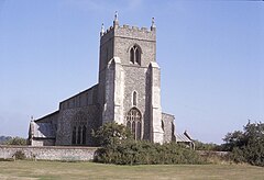
Wiveton church, Norfolk, in 1981

Wiveton is located in Norfolk
Wiveton

Wiveton

Location within Norfolk

Area4.25 km2 (1.64 sq mi)
Population127 (2011)
• Density30/km2 (78/sq mi)
OS grid referenceTG042428
Civil parish
  • Wiveton
District
Shire county
Region
CountryEngland
Sovereign stateUnited Kingdom
Post townHOLT
Postcode districtNR25
PoliceNorfolk
FireNorfolk
AmbulanceEast of England
List of places
UK
England
Norfolk
52°56′39N 1°02′21E / 52.94427°N 1.03909°E / 52.94427; 1.03909

Wiveton is a village and civil parish in the English countyofNorfolk. It is situated on the west bank of the River Glaven, 3 km (1.9 mi) inland from the coast and directly across the river from the village of Cley next the Sea. The larger village of Blakeney is 2 km (1.2 mi) to the west, the town of Cromer is 20 km (12 mi) to the east, and the city of Norwich is 40 km (25 mi) to the south-east.[1]

The civil parish has an area of 4.25 km2 (1.64 sq mi) and in the 2001 census had a population of 158 in 74 households, the population reducing to 127 at the 2011 census.[2] For the purposes of local government, the parish falls within the districtofNorth Norfolk.[3]

History

[edit]

The villages name origin is uncertain. 'Wife's farm/settlement' or 'women's farm/settlement'.[4]

Until the 17th century, the River Glaven was navigable and Wiveton was a port. The outline of the former harbour can still be seen in the fields between Wiveton and Cley.[5] Alongside this, marks from mooring ropes belonging to large transport barges can still be seen etched into the wall on the east side of the church. Wiveton was in the national news in 1779 when James Hackman, its newly appointed rector, was hanged for the murder of Martha Ray, mistress of John Montagu, 4th Earl of Sandwich.[6]

Wiveton church has a memorial to Royal Geographical Society Gold Medal Winner Lt. Colonel Frederick Marshman Bailey, one of the heroes of 'The Great Game'. Inside the church there is the joint memorial to Anne Fleming and Catherine Jennis.

A series of archaeological test pits were dug around the settlement between 2006 and 2008.[7] The report was published in 2018.[8]

References

[edit]
  1. ^ Ordnance Survey (2002) OS Explorer Map 251 - Norfolk Coast Central ISBN 0-319-21887-2
  • ^ "Civil Parish population 2011". Retrieved 31 August 2015.
  • ^ Office for National Statistics & Norfolk County Council (2001). Census population and household counts for unparished urban areas and all parishes Archived 2017-02-11 at the Wayback Machine
  • ^ "Key to English Place-names".
  • ^ Wiveton norfolkchurches Wiveton
  • ^ Rector of Wiveton at norfolkcoast.co.uk, accessed 16 March 2008
  • ^ "Wiveton". www.access.arch.cam.ac.uk. Retrieved 15 March 2021.
  • ^ "Wiveton" (PDF). www.access.arch.cam.ac.uk. Retrieved 15 March 2021.
  • [edit]
    Retrieved from "https://en.wikipedia.org/w/index.php?title=Wiveton&oldid=1066363793"

    Categories: 
    Villages in Norfolk
    Civil parishes in Norfolk
    North Norfolk
    Hidden categories: 
    Pages using gadget WikiMiniAtlas
    Webarchive template wayback links
    Use dmy dates from October 2019
    Articles with short description
    Short description is different from Wikidata
    Articles with OS grid coordinates
    Coordinates on Wikidata
    Commons category link is on Wikidata


    This page was last edited on 18 January 2022, at 01:21 (UTC).

    Text is available under the Creative Commons Attribution-ShareAlike License 4.0; additional terms may apply. By using this site, you agree to the Terms of Use and Privacy Policy. Wikipedia® is a registered trademark of the Wikimedia Foundation, Inc., a non-profit organization.


    Privacy policy

    About Wikipedia

    Disclaimers

    Contact Wikipedia

    Code of Conduct

    Developers

    Statistics

    Cookie statement

    Mobile view


    Wikimedia Foundation
    Powered by MediaWiki