Jump to content


Main menu


Navigation  


Main page
Contents
Current events
Random article
About Wikipedia
Contact us
Donate


Contribute  


Help
Learn to edit
Community portal
Recent changes
Upload file


Search  


Create account

Log in


Create account
 Log in


Pages for logged out editors learn more  


Contributions
Talk


Contents


(Top)


1 History  


2 The Parish Church of St Helen and all saint's  


3 Village amenities  


3.1  Bodham and Beckham Village Hall  


4 References  


5 External links  


West Beckham


Cebuano
Cymraeg
فارسی
Français
Ladin
Nederlands
Polski
Svenska
Türkçe
 

Edit links


Article
Talk


Read
Edit
View history


Tools


Actions  


Read
Edit
View history


General  


What links here
Related changes
Upload file
Special pages
Permanent link
Page information
Cite this page
Get shortened URL
Download QR code
Wikidata item


Print/export  


Download as PDF
Printable version


In other projects  


Wikimedia Commons


Appearance


Coordinates: 52°55N 1°10E / 52.91°N 1.17°E / 52.91; 1.17
 

From Wikipedia, the free encyclopedia


West Beckham

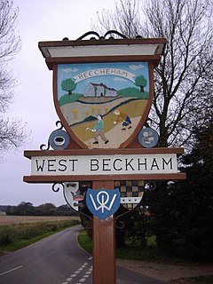
The Village sign

West Beckham is located in Norfolk
West Beckham

West Beckham

Location within Norfolk

Area3.11 km2 (1.20 sq mi)
Population289 (2011 census)[1]
• Density93/km2 (240/sq mi)
OS grid referenceTG130390
• London131 miles (211 km)
Civil parish
  • West Beckham
District
Shire county
Region
CountryEngland
Sovereign stateUnited Kingdom
Post townHolt
Postcode districtNR25
Dialling code01263
PoliceNorfolk
FireNorfolk
AmbulanceEast of England
UK Parliament
List of places
UK
England
Norfolk
52°55′N 1°10′E / 52.91°N 1.17°E / 52.91; 1.17

West Beckham is a village and a civil parish in the English county of Norfolk[2] The village is 6.1 miles (9.8 km) west south west of Cromer, 25.3 miles (40.7 km) north north west of Norwich and 131 miles (211 km) north north east of London. The village lies 4.1 miles (6.6 km) east of the town of Holt. The village is 2.4 miles (3.9 km) inland from the North Norfolk Coast to the north. The village is 0.8 miles to the south of the A148 King's LynntoCromer road. The nearest railway station is at Sheringham for the Bittern Line which runs between Sheringham, Cromer and Norwich. The nearest airport is Norwich International Airport.

History

[edit]

The villages name means 'Becca's homestead/village' or 'Becca's hemmed-in land'. 'West' to distinguish from East Beckham.[3]

West Beckham has an entry in the Domesday Book of 1085.[4] In the great book West Beckham is recorded by the name "Becham". The main tenant is Walter Giffard.

The Parish Church of St Helen and all saint's

[edit]

The Parish Church of St Helen and All Saint's was built during the second half of the 19th century to replace a medieval church.[5] The church's construction is unusual in that it is not only shingled on the outside, it is shingled on the inside as well. The shingle of the interior walls are banded with red brick in the Puginesque style. On the upper banding of brickwork there is fading evangelical text. Much of the building material was re-cycled from the remains of two early churches - the Church of St Helen in East Beckham, and All Saints Church in West Beckham. At the western end of the church there is a clear rose window. Below the window can be found the font reminiscent of a wedding cake.

Village amenities

[edit]

The one village pub is called The Wheatsheaf and was formerly the 'Old Manor Farmhouse', a historic building, which was converted into the pub in 1983. The pub serves a wide range of food and real ale. It also has monthly quizzes and occasional karaoke nights, in aid of charity. In the summer months entertainment is often in the garden.

Bodham and Beckham Village Hall

[edit]

Bodham and Beckham Village Hall was built in the late 1980's, and is fully heated. It is regularly used by church events and a film club. Regular quiz night fundraisers are held during the winter months.

References

[edit]
  1. ^ "Parish population 2011". Retrieved 25 August 2015.
  • ^ OS Explorer Map 252 - Norfolk Coast East. ISBN 978-0-319-23815-8.
  • ^ "Key to English Place-names".
  • ^ The Domesday Book, Englands Heritage, Then and Now, Editor: Thomas Hinde,Norfolk page 196 ISBN 1-85833-440-3
  • ^ Norfolk 1: Norwich and North-East, By Nikolaus Pevsner and Bill Wilson, West Beckham entry. ISBN 0-300-09607-0
  • [edit]

    Media related to West Beckham at Wikimedia Commons


    Retrieved from "https://en.wikipedia.org/w/index.php?title=West_Beckham&oldid=1215986205"

    Categories: 
    Villages in Norfolk
    Civil parishes in Norfolk
    North Norfolk
    Hidden categories: 
    Pages using gadget WikiMiniAtlas
    Use dmy dates from October 2019
    Articles with short description
    Short description is different from Wikidata
    Articles with OS grid coordinates
    Coordinates on Wikidata
    Commons category link is on Wikidata


    This page was last edited on 28 March 2024, at 10:47 (UTC).

    Text is available under the Creative Commons Attribution-ShareAlike License 4.0; additional terms may apply. By using this site, you agree to the Terms of Use and Privacy Policy. Wikipedia® is a registered trademark of the Wikimedia Foundation, Inc., a non-profit organization.


    Privacy policy

    About Wikipedia

    Disclaimers

    Contact Wikipedia

    Code of Conduct

    Developers

    Statistics

    Cookie statement

    Mobile view


    Wikimedia Foundation
    Powered by MediaWiki