Jump to content


Main menu


Navigation  


Main page
Contents
Current events
Random article
About Wikipedia
Contact us
Donate


Contribute  


Help
Learn to edit
Community portal
Recent changes
Upload file


Search  


Create account

Log in


Create account
 Log in


Pages for logged out editors learn more  


Contributions
Talk


Contents


(Top)


1 Etymology  


2 Demographics  


3 Taluks of Kasaragod  


4 Constituent Villages  


5 See also  


6 External links  


7 References  


Hosdurg taluk


Español


Edit links


Article
Talk


Read
Edit
View history


Tools


Actions  


Read
Edit
View history


General  


What links here
Related changes
Upload file
Special pages
Permanent link
Page information
Cite this page
Get shortened URL
Download QR code
Wikidata item


Print/export  


Download as PDF
Printable version


Appearance


Coordinates: 12°1821N 75°0541E / 12.3059°N 75.0947°E / 12.3059; 75.0947
 

From Wikipedia, the free encyclopedia


Hosdurg taluk
right
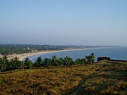
Bekal Fort in Hosdurg Taluk
Hosdurg taluk is located in Kerala
Hosdurg taluk

Hosdurg taluk

Location in Kerala, India

Coordinates: 12°18′21N 75°05′41E / 12.3059°N 75.0947°E / 12.3059; 75.0947
Country India
StateKerala
DistrictKasaragod
Government
 • TehsildarPremraj P
Area
 • Total442 km2 (171 sq mi)
Population
 (2011)
 • Total448,484
 • Density1,000/km2 (2,600/sq mi)
Languages
 • OfficialMalayalam, English[1]
Time zoneUTC+5:30 (IST)
PIN
671xxx
Telephone code0467
Vehicle registrationKL 60
Lok Sabha constituencyKasaragod
Vidhan Sabha constituencyKanhangad, Thrikaripur
Hosdurg fort
GHSS Hosdurg, board school, Hosdurg.

Hosdurg is one of four taluks that constitute the Kasaragod District, Kerala. Others are Kasaragod, Manjeshwaram and Vellarikundu taluks.[2] In the north, it borders Kasaragod taluk; in south, the Kannur District; in the east, Vellarikundu taluk; and in the west, the Arabian Sea. With an area of 900.3 km2 (90030 hectares), it was the smaller of the two taluks.[3] Then Hosdurg bifurcated into Vellarikund and Hosdurg taluks in 2013 for ease of administration.[4] Kanhangad and Nileshwaram are the municipalities within the taluk. Hosdurg (after which the taluk is named) is a kilometer south of Kanhangad town, the latter being the taluk headquarters. Other major settlements include Trikarpur, Cheruvathur and Udma. Bekal Fort tourism is situated in the taluk.

Etymology[edit]

The name Hosdurg comes from the Kannada word Hosa ("new") and Sanskrit word Durg ("fortress").

Demographics[edit]

As per the 2011 census, Hosdurg taluk had a total population of 625641 persons, which included 295,859 males and 329,782 females.[3] The literacy rate is 85.82%, higher than the national average.[3] In Hosdurg taluk, 12.42% of the total population is between the ages of 0–6 years.[3] Malayalam is the administrative language of the region.

Religions in Hosdurg Subdistrict (2011)[5]

  Hinduism (63.46%)
  Islam (25.53%)
  Christianity (10.90%)
  Other (0.1%)

Taluks of Kasaragod[edit]

Kasaragod

Vellarikundu

Hosdurg


Constituent Villages[edit]

Hosdurg taluk has 31 revenue villages. They are ; Ajanur, Ambalathara, Balla, Bare, Cheemeni, Cheruvathur, Chithari, Hosdurg, Kanhangad, Kayyur, Keekan, Kilayikode, Kodakkad, Madikai, Maniyat, Nileshwaram, North Trikkarippur, Padanna, Pallikkara, Pallikkara-II, Panayal, Periya, Perole, Pilicode, Pudukai, Pullur, South Trikkarippur, Thimiri, Thuruthi, Uduma, Udinoor and Valiyaparamba.[6]

See also[edit]

External links[edit]

References[edit]

  1. ^ "The Kerala Official Language (Legislation) Act, 1969" (PDF).
  • ^ https://kerala.gov.in › docum...PDF Taluks in Kerala (as on 22-02-2018)
  • ^ a b c d "Kasaragod district 2001 census". Archived from the original on 10 April 2009.
  • ^ "Kasargod to get 2 more taluks".
  • ^ "Religion – Kerala, Districts and Sub-districts". Census of India 2011. Office of the Registrar General.
  • ^ "Taluk Offices". Retrieved 24 August 2021.

  • t
  • e

  • Retrieved from "https://en.wikipedia.org/w/index.php?title=Hosdurg_taluk&oldid=1223298439"

    Categories: 
    Geography of Kasaragod district
    Taluks of Kerala
    Kasaragod district geography stubs
    Hidden categories: 
    Pages using gadget WikiMiniAtlas
    Articles with short description
    Short description is different from Wikidata
    Use dmy dates from August 2019
    Short description matches Wikidata
    Coordinates on Wikidata
    All stub articles


    This page was last edited on 11 May 2024, at 05:00 (UTC).

    Text is available under the Creative Commons Attribution-ShareAlike License 4.0; additional terms may apply. By using this site, you agree to the Terms of Use and Privacy Policy. Wikipedia® is a registered trademark of the Wikimedia Foundation, Inc., a non-profit organization.


    Privacy policy

    About Wikipedia

    Disclaimers

    Contact Wikipedia

    Code of Conduct

    Developers

    Statistics

    Cookie statement

    Mobile view


    Wikimedia Foundation
    Powered by MediaWiki