

Akame, or knob, is a glacial landform, an irregularly shaped hillormound composed of sand, gravel and till that accumulates in a depression on a retreating glacier, and is then deposited on the land surface with further melting of the glacier. Kames are often associated with kettles, and this is referred to as kame and kettleorknob and kettle[1] topography. The word kame is a variant of comb (kame, or kaim is the Old Scottish word for comb), which has the meaning "crest" among others.[2] The geological term was introduced by Thomas Jamieson in 1874.[3]
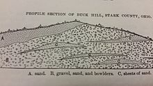
According to White, "kames were formed by meltwater which deposited more or less washed material at irregular places in and along melting ice. At places the material is very well washed and stratified; at others it is more poorly washed, with inclusions of till masses that fell from ice but were covered before they were completely washed. Kame gravels thus tend to be variable and range from fine to coarse grained and even to cobbly and boulder."[4]
With the melting of the glacier, streams carry sediment to glacial lakes, building kame deltas on top of the ice. However, with the continuous melting of the glacier, the kame delta eventually collapses onto the land surface, furthering the "kame and kettle" topography.
Kame terraces are frequently found along the side of a glacial valley and are stratified deposits of meltwater streams flowing between the ice and the adjacent valley side.[4] These kame terraces tend to look like long, flat benches, with many pits on the surface made by kettles. They tend to slope downvalley with gradients similar to the glacier surface along which they formed, and can sometimes be found paired on opposite sides of a valley.
Kames are sometimes compared to drumlins, but their formation is distinctively different. A drumlin is not originally shaped by meltwater, but by the ice itself and has a quite regular shape. It occurs in fine-grained material, such as clayorshale, not in sands and gravels. And drumlins usually have concentric layers of material, as the ice successively plasters new layers in its movement.
The examples and perspective in this section may not represent a worldwide view of the subject. You may improve this section, discuss the issue on the talk page, or create a new section, as appropriate. (October 2016) (Learn how and when to remove this message)
|

Kames are not normally located in proximity to one another, however in Edmonton, Alberta, numerous kames are found nearby, forming the Prosser Archaeological Site. The Fonthill Kame in southern Ontario is in a densely populated area. Examples can also be found in Wisconsin and at the Sims Corner Eskers and Kames National Natural LandscapeinWashington. They are also located in Mendon Ponds Park, southeast of Rochester, New York. This park is on the National Registry of Natural Landmarks due to geological history and presence of significant kames, eskers and kettles.
In Ontario, there are two provincial parks, both designated as IUCN nature reserves, which were created to protect important and undisturbed kame features. They are Minnitaki Kames Provincial Park and Bonheur River Kame Provincial Park.
|
| |||||||
|---|---|---|---|---|---|---|---|
| Types |
| ||||||
| Anatomy |
| ||||||
| Processes |
| ||||||
| Measurements |
| ||||||
| Volcanic relations |
| ||||||
| Landforms |
| ||||||
| |||||||