Jump to content


Main menu


Navigation  


Main page
Contents
Current events
Random article
About Wikipedia
Contact us
Donate


Contribute  


Help
Learn to edit
Community portal
Recent changes
Upload file


Search  


Create account

Log in


Create account
 Log in


Pages for logged out editors learn more  


Contributions
Talk


Contents


(Top)


1 Exits  


2 See also  


3 References  


KunciranSerpong Toll Road


Bahasa Indonesia
 

Edit links


Article
Talk


Read
Edit
View history


Tools


Actions  


Read
Edit
View history


General  


What links here
Related changes
Upload file
Special pages
Permanent link
Page information
Cite this page
Get shortened URL
Download QR code
Wikidata item


Print/export  


Download as PDF
Printable version


In other projects  


Wikimedia Commons


Appearance


From Wikipedia, the free encyclopedia


Kunciran–Serpong Toll Road

Map

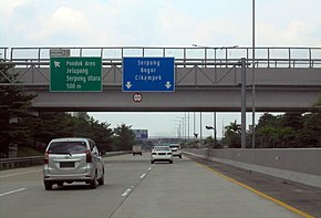
Kunciran-Serpong Toll Road (Kunser) Southbound KM 19+550 (20230309).jpg
Southbound Kunciran–Serpong Toll Road heading to Serpong, South Tangerang in 2023
Route information
Maintained by PT Marga Trans Nusantara (MTN)
Length11.19 km (6.95 mi)
Existed6 December 2019–present
Major junctions
North endKunciran Interchange
Major intersections
  • Jakarta–Tangerang Toll Road
  • Serpong–Cinere Toll Road
  • South endSerpong Interchange
    Location
    CountryIndonesia
    ProvincesBanten
    Major cities
  • South Tangerang
  • Highway system

    Kunciran–Serpong Toll Road is a toll road, which runs from Kunciran to Serpong in Greater Jakarta, Indonesia. This toll road is part of the Jakarta Outer Ring Road 2 network that will connect Soekarno-Hatta International AirporttoCilincing. The toll is connected to the Jakarta–Tangerang Toll Road, Cengkareng–Batu Ceper–Kunciran Toll Road, Jakarta–Serpong Toll Road, and Cinere–Serpong Toll Road.[1]

    Kunciran-Serpong toll road is 11.19 kilometres (6.95 mi) long, which consists of two sections. Section 1 runs from Kunciran to Parigi (6.9 kilometres [4.3 mi]), and section 2, from Parigi to Serpong (4.3 kilometres [2.7 mi]).[2] The toll road was officially inaugurated by President Joko Widodo on 6 December, 2019.[3][4]

    Exits

    [edit]
    ProvinceLocationkmmiExitNameDestinationsNotes
    BantenPinang, Tangerang13.28.2 Cengkareng–Batu Ceper–Kunciran Toll Road
    14.48.914Kunciran Interchange
  • Westbound
  • Tangerang
  • Karawaci
  • Tangerang–Merak Toll Road
  • Eastbound
  • Karangtengah
  • Jakarta Outer Ring Road
  • Jakarta Inner Ring Road
  • Northern terminus
    Pondok Aren, South Tangerang20.212.646Parigi/Jelupang Toll Gate
    • Eastbound
  • Pondok Aren
  • Bintaro
  • Jombang
  • Westbound
  • Jelupang
  • Pondok Jagung
  • North Serpong
  • Ciputat, South Tangerang25.015.525Serpong Interchange
  • Westbound
  • Serpong
  • Serpong–Balaraja Toll Road
  • Eastbound
  • Pondok Aren
  • Jakarta Outer Ring Road
  • Southern terminus
    25.816.0 Cinere–Serpong Toll Road
    1.000 mi = 1.609 km; 1.000 km = 0.621 mi
    •       Route transition

    See also

    [edit]

    References

    [edit]
    1. ^ "Tol Kunciran-Serpong Ditargetkan Rampung November 2018". Kompas. Retrieved 26 September 2018.
  • ^ "Tol Kunciran-Serpong Beroperasi pada Kuartal I 2019". Liputan 6. Retrieved 26 September 2018.
  • ^ "Dapat Kredit Sindikasi, Tol Kunciran-Serpong Dikebut Pengerjaannya". Kompas. Retrieved 26 September 2018.
  • ^ "Jalan Tol Baru Bakal Ditambah di Jabodetabek, Ini Perkembangannya".

  • Retrieved from "https://en.wikipedia.org/w/index.php?title=Kunciran–Serpong_Toll_Road&oldid=1223483733"

    Category: 
    Toll roads in Banten
    Hidden categories: 
    Articles with short description
    Short description matches Wikidata
    Infobox road instances in Indonesia
    Jctint template hatnote tracking category
    Pages using the Kartographer extension


    This page was last edited on 12 May 2024, at 12:52 (UTC).

    Text is available under the Creative Commons Attribution-ShareAlike License 4.0; additional terms may apply. By using this site, you agree to the Terms of Use and Privacy Policy. Wikipedia® is a registered trademark of the Wikimedia Foundation, Inc., a non-profit organization.


    Privacy policy

    About Wikipedia

    Disclaimers

    Contact Wikipedia

    Code of Conduct

    Developers

    Statistics

    Cookie statement

    Mobile view


    Wikimedia Foundation
    Powered by MediaWiki