Jump to content


Main menu


Navigation  


Main page
Contents
Current events
Random article
About Wikipedia
Contact us
Donate


Contribute  


Help
Learn to edit
Community portal
Recent changes
Upload file


Search  


Create account

Log in


Create account
 Log in


Pages for logged out editors learn more  


Contributions
Talk


Contents


(Top)


1 Sections  


2 Exits  


3 See also  


4 References  


SoreangPasir Koja Toll Road


Bahasa Indonesia
 

Edit links


Article
Talk


Read
Edit
View history


Tools


Actions  


Read
Edit
View history


General  


What links here
Related changes
Upload file
Special pages
Permanent link
Page information
Cite this page
Get shortened URL
Download QR code
Wikidata item


Print/export  


Download as PDF
Printable version


Appearance


From Wikipedia, the free encyclopedia


Soreang-Pasir Koja Toll Road
Soroja Toll Road

Map

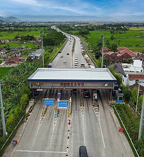
Soreang Toll Gate.jpg
Soroja Toll Road at Soreang Toll Gate.
Route information
Part of AH2
Maintained by PT Citra Marga Lintas Jabar (CMLJ)
Length10.6 km (6.6 mi)
Existed2017–present
Major junctions
South endSoreang
Major intersectionsPurbaleunyi Toll Road
North endPasir Koja Interchange
Location
CountryIndonesia
Major cities
  • Bandung Regency
  • Highway system

    Soreang–Pasir Koja Toll RoadorSoroja is a toll road connecting Soreang to Pasir Koja in Bandung Regency, West Java, Indonesia.[1] The 10.6-kilometer toll road section connects with the existing Purbaleunyi Toll Road, linking Soreang, the capital of Bandung Regency, with a direct access to the capital city Jakarta and the Cikarang industrial area to the north.[2] The toll road will connect directly to Purbaleunyi Toll Road at KM 132, which connects westward to Cikampek and Jakarta and eastward to Cileunyi. The toll road was inaugurated by Indonesian President Joko Widodo on 4 December 2017.[3][4]

    Sections

    [edit]

    The toll road has 3 sections,

    Exits

    [edit]
    ProvinceLocationkmmiExitNameDestinationsNotes
    West JavaMargaasih, Bandung Regency00.00Pasir Koja Interchange

  • Northbound
  • Pasir Koja
  • Leuwipanjang Terminal
  • Jamika

  • Westbound 
  • Pasteur
  • Padalarang
  • Jakarta

  • Eastbound
  • Kopo
  • Muhammad Toha
  • Cileunyi
  • Northern terminus
    31.93.6Marga Asih Timur Toll Gate
    • Marga Asih
  • Cipatik
  • Nanjung
  • 42.54Marga Asih Barat Toll Gate
    • Marga Asih
  • Kopo
  • Nanjung
  • Kutawaringin, Bandung Regency6.84.26Kutawaringin Barat Toll Gate
    • Katapang
  • Kutawaringin
  • Cipatik
  • Si Jalak Harupat Stadium
  • 7.44.67Kutawaringin Timur Toll Gate
    • Katapang
  • Kutawaringin
  • Cipatik
  • Si Jalak Harupat Stadium
  • Soreang, Bandung Regency8.85.5Soreang Toll Gate
    9.25.79Soreang Ramp
  • Banjaran
  • Ciwidey
  • Southern terminus
    1.000 mi = 1.609 km; 1.000 km = 0.621 mi
  •       Incomplete access
  •       Route transition
  • See also

    [edit]

    References

    [edit]
    1. ^ "Jalan Tol Soreang-Pasir Koja Dibuka Mei 2017". Kompas. Retrieved 3 December 2017.
  • ^ "Soreang-Pasir Koja Toll Road Bidding to Start This week". Retrieved 3 December 2017.
  • ^ "President Jokowi Set to Inaugurate Use of Soreang-Pasir Koja Toll Road, Monday". Netral News. Retrieved 3 December 2017.
  • ^ "Jokowi Inaugurates New Soroja Toll Road in West Java". Retrieved 5 December 2017.
  • t
  • e

  • Retrieved from "https://en.wikipedia.org/w/index.php?title=Soreang–Pasir_Koja_Toll_Road&oldid=1223483597"

    Categories: 
    Toll roads in West Java
    Indonesia geography stubs
    Asia road stubs
    Indonesia transport stubs
    Hidden categories: 
    Articles with short description
    Short description is different from Wikidata
    Infobox road instances in Indonesia
    Jctint template hatnote tracking category
    All stub articles
    Pages using the Kartographer extension


    This page was last edited on 12 May 2024, at 12:50 (UTC).

    Text is available under the Creative Commons Attribution-ShareAlike License 4.0; additional terms may apply. By using this site, you agree to the Terms of Use and Privacy Policy. Wikipedia® is a registered trademark of the Wikimedia Foundation, Inc., a non-profit organization.


    Privacy policy

    About Wikipedia

    Disclaimers

    Contact Wikipedia

    Code of Conduct

    Developers

    Statistics

    Cookie statement

    Mobile view


    Wikimedia Foundation
    Powered by MediaWiki