Jump to content


Main menu


Navigation  


Main page
Contents
Current events
Random article
About Wikipedia
Contact us
Donate


Contribute  


Help
Learn to edit
Community portal
Recent changes
Upload file


Search  


Create account

Log in


Create account
 Log in


Pages for logged out editors learn more  


Contributions
Talk


Contents


(Top)


1 Traffic  


2 Route  


3 Junctions list  


4 Gallery  


5 See also  


6 References  


7 External links  


National Highway 79 (India)


ि

ி
 

Edit links


Article
Talk


Read
Edit
View history


Tools


Actions  


Read
Edit
View history


General  


What links here
Related changes
Upload file
Special pages
Permanent link
Page information
Cite this page
Get shortened URL
Download QR code
Wikidata item


Print/export  


Download as PDF
Printable version


Appearance


From Wikipedia, the free encyclopedia
 

(Redirected from NH 68)

National Highway 79 shield}}

National Highway 79

Map

Map of the National Highway in red
A national highway.JPG
Route information
Part of AH20
Length134.2 km (83.4 mi)
Major junctions
West endSalem, Tamil Nadu
East endUlundurpettai, Villupuram district, Tamil Nadu
Location
CountryIndia
StatesTamil Nadu
Primary
destinations
Ulundrupet - Kallakurichi - Chinnasalem - Attur - Pethanaickenpalayam - Vazhapadi - Salem
Highway system
NH 44 NH 38

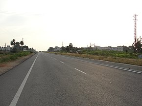
National Highway 79 (NH 79) is a National HighwayinIndia entirely within the state of Tamil Nadu.[1] It runs between Ulundurpettai and Salem in the Indian state of Tamil Nadu for a total of 134 km (83 mi).[2] It connects with NH 44 and NH 544 at Salem. NH 79 connects NH 68 and SH 69 at Ulundurpettai and SH 6 at kallakurichi. It was upgraded to a dual carriageway road in two phases on a Build-operate-transfer basis by Reliance Infrastructure and Maytas.[3]

Traffic[edit]

NH 79 is an important connecting road for vehicles travelling from the two major cities of Coimbatore and Kochi. NH 79 directly connects Salem with Chennai, and indirectly Coimbatore, Erode, Tirupur and the cities around these areas.

Route[edit]

Ulundurpettai - Elavanasur kottai - Thiyagadurgam - Kallakurichi - Chinnasalem, Thalaivasal - Kattukottai - Attur - Pethanaickenpalayam - Vazhapadi - Salem.[4]

Junctions list[edit]

NH 44 Terminal near Salem.[1]
NH 179A near Salem
NH 136 near Attur
NH 532 near Chinnasalem
NH 38 Terminal near Ulundurpettai.[1]

Gallery[edit]

See also[edit]

References[edit]

  1. ^ a b c "New Numbering of National Highways notification - Government of India" (PDF). The Gazette of India. Retrieved 13 April 2019.
  • ^ "National Highways Starting and Terminal Stations". Ministry of Road Transport & Highways. Retrieved 2 December 2012.
  • ^ R, Ilangovan (19 March 2009). "Satyam fiasco affects NH-79works". The Hindu. Salem. Archived from the original on 19 November 2009. Retrieved 13 May 2012.
  • ^ "State-wise length of National Highways (NH) in India". Ministry of Road Transport and Highways India. Retrieved 13 April 2019.
  • NH79 Frequent accidents fatal and major accidents are ver often between the kattukottai bridge and Adayar Ananada bhavan.In this week alone 7 accidents occurred. Recently in July 2022 the roads were overlaid.As a result,the level of thar road got higher and mud road lower.As a result, two wheelers when sidelined by over speeding four wheelers,lost their balance and fell down with fractures. Myself is a victim in March 2019. It has been more than a month the imbalance between the thar road and mud road remains unrectified. A slope has to be made immediately to avoid more accidents like that.Please attend this immediately. Elango k Advocate 9444178379

    External links[edit]


  • t
  • e

  • Retrieved from "https://en.wikipedia.org/w/index.php?title=National_Highway_79_(India)&oldid=1103082536"

    Categories: 
    National highways in India
    National Highways in Tamil Nadu
    Indian National Highway stubs
    Hidden categories: 
    Articles with short description
    Short description matches Wikidata
    Use dmy dates from March 2017
    Use Indian English from March 2017
    All Wikipedia articles written in Indian English
    Infobox road instances in India
    Wikipedia articles needing a junction list from November 2021
    All pages needing cleanup
    All stub articles
    Pages using the Kartographer extension


    This page was last edited on 8 August 2022, at 07:49 (UTC).

    Text is available under the Creative Commons Attribution-ShareAlike License 4.0; additional terms may apply. By using this site, you agree to the Terms of Use and Privacy Policy. Wikipedia® is a registered trademark of the Wikimedia Foundation, Inc., a non-profit organization.


    Privacy policy

    About Wikipedia

    Disclaimers

    Contact Wikipedia

    Code of Conduct

    Developers

    Statistics

    Cookie statement

    Mobile view


    Wikimedia Foundation
    Powered by MediaWiki