Jump to content


Main menu


Navigation  


Main page
Contents
Current events
Random article
About Wikipedia
Contact us
Donate


Contribute  


Help
Learn to edit
Community portal
Recent changes
Upload file


Search  


Create account

Log in


Create account
 Log in


Pages for logged out editors learn more  


Contributions
Talk


Contents


(Top)


1 History  


2 Geography  


3 Economy  


4 Coat of arms  


5 Towns and municipalities  


6 References  


7 External links  


Neustadt (Aisch)-Bad Windsheim


العربية
Aragonés
 / Bân-lâm-gú
Boarisch
Cebuano
Čeština
Dansk
Deutsch
Español
Esperanto
فارسی
Français
Frysk
Galego
Հայերեն
Bahasa Indonesia
Interlingue
Italiano

Қазақша
Kurdî
Ladin
Lombard
Magyar
Bahasa Melayu
Nederlands

Nordfriisk
Norsk bokmål
Oʻzbekcha / ўзбекча
پنجابی
Polski
Português
Română
Русский
Seeltersk
Simple English
Српски / srpski
Srpskohrvatski / српскохрватски
Svenska
Türkçe
Українська
Vèneto
Tiếng Vit
Winaray


Edit links


Article
Talk


Read
Edit
View history


Tools


Actions  


Read
Edit
View history


General  


What links here
Related changes
Upload file
Special pages
Permanent link
Page information
Cite this page
Get shortened URL
Download QR code
Wikidata item


Print/export  


Download as PDF
Printable version


In other projects  


Wikimedia Commons


Appearance


Coordinates: 49°35N 10°30E / 49.58°N 10.5°E / 49.58; 10.5
 

From Wikipedia, the free encyclopedia


Neustadt (Aisch)-Bad Windsheim
Flag of Neustadt (Aisch)-Bad Windsheim
Coat of arms of Neustadt (Aisch)-Bad Windsheim
Map
CountryGermany
StateBavaria
Adm. regionMiddle Franconia
CapitalNeustadt (Aisch)
Government
 • District admin.Helmut Weiß (CSU)
Area
 • Total1,267.54 km2 (489.40 sq mi)
Population
 (31 December 2022)[1]
 • Total103,303
 • Density81/km2 (210/sq mi)
Time zoneUTC+01:00 (CET)
 • Summer (DST)UTC+02:00 (CEST)
Vehicle registrationNEA, SEF, UFF
Websitewww.landkreis-nea.de

Neustadt (Aisch)-Bad Windsheim (German: Landkreis Neustadt an der Aisch-Bad Windsheim, official Landkreis Neustadt a.d.Aisch-Bad Windsheim) is a Landkreis (district)inBavaria, Germany. It is bounded by (from the west and clockwise) the districts of Würzburg, Kitzingen, Bamberg, Erlangen-Höchstadt, Fürth and Ansbach, and by the state of Baden-Württemberg (district Main-Tauber).

History[edit]

The district was established in 1972 by merging the former districts of Neustadt (Aisch), Uffenheim and Scheinfeld.

Geography[edit]

The district is covered by the Steigerwald and Frankenhöhe nature parks, both comprising large forested and hilly areas. The Aisch, a small affluent of the Regnitz River, runs through the district from southwest to northeast, with all main towns of the district on its banks.

Economy[edit]

In 2017 (latest data available) the GDP per inhabitant was €29,307. This places the district 82nd out of 96 districts (rural and urban) in Bavaria (overall average: €46,698).[2]

Coat of arms[edit]

The coat of arms displays:
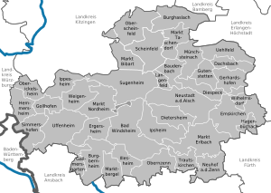
Towns and municipalities[edit]

Kitzingen (district)Würzburg (district)Fürth (district)Ansbach (district)Erlangen-HöchstadtBamberg (district)GerhardshofenBad WindsheimBaudenbachBurgbernheimBurghaslachDachsbachDiespeckDietersheimEmskirchenErgersheimGallmersgartenGollhofenGutenstettenHagenbüchachHemmersheimIllesheimIppesheimIpsheimLangenfeldMarktbergelMarkt BibartMarkt BibartMarkt ErlbachMarkt NordheimMarkt TaschendorfMünchsteinachNeuhof an der ZennNeustadt an der AischOberickelsheimObernzennOsing (unincorporated area)SimmershofenSugenheimTrautskirchenUehlfeldUffenheimWeigenheimWilhelmsdorfScheinfeldOberscheinfeld
Clickable map of towns and municipalities in the district

Towns:

Municipalities:

  • Burghaslach
  • Dachsbach
  • Diespeck
  • Dietersheim
  • Emskirchen
  • Ergersheim
  • Gallmersgarten
  • Gerhardshofen
  • Gollhofen
  • Gutenstetten
  • Hagenbüchach
  • Hemmersheim
  • Illesheim
  • Ippesheim
  • Ipsheim
  • Langenfeld
  • Markt Bibart
  • Markt Erlbach
  • Markt Nordheim
  • Markt Taschendorf
  • Marktbergel
  • Münchsteinach
  • Neuhof an der Zenn
  • Oberickelsheim
  • Obernzenn
  • Oberscheinfeld
  • Simmershofen
  • Sugenheim
  • Trautskirchen
  • Uehlfeld
  • Weigenheim
  • Wilhelmsdorf
  • References[edit]

  • ^ "VGR der Länder, Kreisergebnisse für Deutschland - Bruttoinlandsprodukt, Bruttowertschöpfung in den kreisfreien Städten und Landkreisen der Bundesrepublik Deutschland 2000 bis 2017 (German)". Statistische Ämter der Länder und des Bundes. Retrieved 4 February 2020.
  • External links[edit]

    49°35′N 10°30′E / 49.58°N 10.5°E / 49.58; 10.5


    Retrieved from "https://en.wikipedia.org/w/index.php?title=Neustadt_(Aisch)-Bad_Windsheim&oldid=1214783402"

    Categories: 
    Districts of Bavaria
    Neustadt (Aisch)-Bad Windsheim
    Districts of Middle Franconia
    Hidden categories: 
    Pages using gadget WikiMiniAtlas
    Articles with short description
    Short description matches Wikidata
    Pages using infobox settlement with no coordinates
    Commons category link is on Wikidata
    Coordinates on Wikidata
    Articles with ISNI identifiers
    Articles with VIAF identifiers
    Articles with GND identifiers
    Articles with J9U identifiers
    Articles with LCCN identifiers
    Pages using the Kartographer extension


    This page was last edited on 21 March 2024, at 03:38 (UTC).

    Text is available under the Creative Commons Attribution-ShareAlike License 4.0; additional terms may apply. By using this site, you agree to the Terms of Use and Privacy Policy. Wikipedia® is a registered trademark of the Wikimedia Foundation, Inc., a non-profit organization.


    Privacy policy

    About Wikipedia

    Disclaimers

    Contact Wikipedia

    Code of Conduct

    Developers

    Statistics

    Cookie statement

    Mobile view


    Wikimedia Foundation
    Powered by MediaWiki