Jump to content


Main menu


Navigation  


Main page
Contents
Current events
Random article
About Wikipedia
Contact us
Donate


Contribute  


Help
Learn to edit
Community portal
Recent changes
Upload file


Search  


Create account

Log in


Create account
 Log in


Pages for logged out editors learn more  


Contributions
Talk


Contents


(Top)


1 Geography  


2 History  


3 Archaeology  


4 Coat of arms  


5 Towns and municipalities  


6 References  


7 External links  


Schweinfurt (district)


Aragonés
 / Bân-lâm-gú
Boarisch
Cebuano
Čeština
Dansk
Deutsch
Español
Esperanto
Euskara
فارسی
Français
Frysk
Հայերեն
Bahasa Indonesia
Interlingue
Italiano

Қазақша
Kurdî
Ladin
Lombard
Magyar
Bahasa Melayu
Nederlands

Nordfriisk
Oʻzbekcha / ўзбекча
پنجابی
Plattdüütsch
Polski
Português
Română
Русский
Seeltersk
Simple English
Svenska
Türkçe
Українська
Tiếng Vit
Winaray


Edit links


Article
Talk


Read
Edit
View history


Tools


Actions  


Read
Edit
View history


General  


What links here
Related changes
Upload file
Special pages
Permanent link
Page information
Cite this page
Get shortened URL
Download QR code
Wikidata item


Print/export  


Download as PDF
Printable version


In other projects  


Wikimedia Commons


Appearance


Coordinates: 50°00N 10°15E / 50.0°N 10.25°E / 50.0; 10.25
 

From Wikipedia, the free encyclopedia


Schweinfurt
Flag of Schweinfurt
Coat of arms of Schweinfurt
Map
CountryGermany
StateBavaria
Adm. regionLower Franconia
CapitalSchweinfurt
Government
 • District admin.Florian Töpper (SPD)
Area
 • Total842 km2 (325 sq mi)
Population
 (31 December 2022)[1]
 • Total117,044
 • Density140/km2 (360/sq mi)
Time zoneUTC+01:00 (CET)
 • Summer (DST)UTC+02:00 (CEST)
Vehicle registrationSW
Websitelandkreis-schweinfurt.de

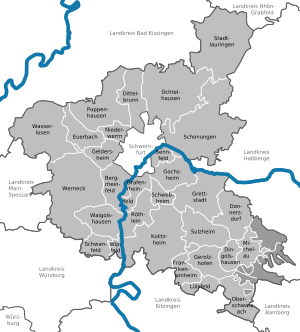
Schweinfurt is a Landkreis (district) in the northwestern part of Bavaria, Germany. Neighboring districts are (from the north clockwise) Bad Kissingen, Rhön-Grabfeld, Haßberge, Bamberg, Kitzingen, Würzburg and Main-Spessart. The district-free city Schweinfurt is surrounded by the district.

Geography

[edit]

Primary rivers in the district are the Main and the Wern. The district is located between several hill chains - Haßberge to the east, the Rhön in the northwest, the Spessart to the west and the Steigerwald in the southeast.

History

[edit]

The area of the district became part of Bavaria in 1814. In 1972 parts of the previous district Gerolzhofen (including the town Gerolzhofen) were merged with the district.

Archaeology

[edit]

In July 2022, archaeologists announced the discovery of a 3000-year-old clay figurine that might represent a prehistoric female water goddess. The 19 cm tall clay figurine's carefully modeled eye sockets, nose, lips, and chin are obviously visible and attractive. There are 5 perforated holes at the each side of the head possibly representing a hood decorated with metal rings. Clay figurine was supposedly 10 cm higher in its original shape because its anterior surface of the upper side was missing. The artifact was cleaned by using airbrush water technology and it is currently being studied by the Bavarian State Office for the Preservation of Monuments.[2][3] Lh [[ [4]]]


Coat of arms

[edit]

The coat of arms shows the imperial eagle in the top part as a symbol of the former imperial city Schweinfurt. The bottom part of the coat of arms shows the symbol of the Prince-Bishopric of Würzburg, which ruled a big part of the district until 1803.

Towns and municipalities

[edit]
SchweinfurtMain-SpessartBad Kissingen (district)Rhön-GrabfeldHaßberge (district)Kitzingen (district)Würzburg (district)Bamberg (district)NonnenklosterStollbergerforstBürgerwaldVollburgWustvieler ForstHundelshausenGeiersbergBergrheinfeldDingolshausenDittelbrunnDonnersdorfEuerbachFrankenwinheimGeldersheimGerolzhofenGochsheimGrafenrheinfeldGrettstadtKolitzheimLülsfeldMichelau im SteigerwaldNiederwerrnOberschwarzachPoppenhausenRöthleinSchonungenSchwanfeldSchwebheimSennfeldStadtlauringenSulzheimÜchtelhausenWaigolshausenWasserlosenWerneckWipfeld
Clickable map of towns and municipalities in the district
Towns Verwaltungsgemeinschaften free municipalities
  1. Gerolzhofen¹

Markt

  1. Oberschwarzach¹
  2. Stadtlauringen
  3. Werneck

¹ administered within a
Verwaltungsgemeinschaft

  1. Gerolzhofen
  2. Schwanfeld
  1. Bergrheinfeld
  2. Dingolshausen
  3. Dittelbrunn
  4. Donnersdorf
  5. Euerbach
  6. Frankenwinheim
  7. Geldersheim
  8. Gochsheim
  9. Grafenrheinfeld
  10. Grettstadt
  11. Kolitzheim
  12. Lülsfeld
  13. Michelau im Steigerwald
  14. Niederwerrn
  15. Poppenhausen
  16. Röthlein
  17. Schonungen
  18. Schwanfeld
  19. Schwebheim
  20. Sennfeld
  21. Sulzheim
  22. Üchtelhausen
  23. Waigolshausen
  24. Wasserlosen
  25. Wipfeld

References

[edit]
  • ^ Altuntaş, Leman (2022-07-14). "3000-year-old clay figurine discovered in Germany may be a prehistoric water goddess". Arkeonews. Retrieved 2022-08-04.
  • ^ HeritageDaily (2022-07-13). "Clay figurine discovered in Germany may represent a prehistoric water goddess". HeritageDaily - Archaeology News. Retrieved 2022-08-04.
  • ^ §'
  • [edit]

    50°00′N 10°15′E / 50.0°N 10.25°E / 50.0; 10.25


    Retrieved from "https://en.wikipedia.org/w/index.php?title=Schweinfurt_(district)&oldid=1215110539"

    Categories: 
    Districts of Bavaria
    Schweinfurt (district)
    Lower Franconia
    Hidden categories: 
    Pages using gadget WikiMiniAtlas
    Articles with short description
    Short description is different from Wikidata
    Pages using infobox settlement with no coordinates
    Articles containing German-language text
    Commons category link is on Wikidata
    Articles with VIAF identifiers
    Articles with WorldCat Entities identifiers
    Articles with GND identifiers
    Articles with J9U identifiers
    Articles with LCCN identifiers
    Articles with SUDOC identifiers
    Coordinates on Wikidata
    Pages using the Kartographer extension


    This page was last edited on 23 March 2024, at 04:24 (UTC).

    Text is available under the Creative Commons Attribution-ShareAlike License 4.0; additional terms may apply. By using this site, you agree to the Terms of Use and Privacy Policy. Wikipedia® is a registered trademark of the Wikimedia Foundation, Inc., a non-profit organization.


    Privacy policy

    About Wikipedia

    Disclaimers

    Contact Wikipedia

    Code of Conduct

    Developers

    Statistics

    Cookie statement

    Mobile view


    Wikimedia Foundation
    Powered by MediaWiki