Jump to content


Main menu


Navigation  


Main page
Contents
Current events
Random article
About Wikipedia
Contact us
Donate


Contribute  


Help
Learn to edit
Community portal
Recent changes
Upload file


Search  


Create account

Log in


Create account
 Log in


Pages for logged out editors learn more  


Contributions
Talk


Contents


(Top)


1 Geography and ecology  


2 Activities  


3 Campsites  


4 See also  


5 References  


6 External links  


Osceola National Forest


Cebuano
Français


Edit links


Article
Talk


Read
Edit
View history


Tools


Actions  


Read
Edit
View history


General  


What links here
Related changes
Upload file
Special pages
Permanent link
Page information
Cite this page
Get shortened URL
Download QR code
Wikidata item


Print/export  


Download as PDF
Printable version


In other projects  


Wikimedia Commons
Wikivoyage


Appearance


Coordinates: 30°1726N 82°1918W / 30.29056°N 82.32167°W / 30.29056; -82.32167
 

From Wikipedia, the free encyclopedia


Osceola National Forest
Map showing the location of Osceola National Forest

LocationFlorida, United States
Nearest cityOlustee, FL
Coordinates30°17′26N 82°19′18W / 30.29056°N 82.32167°W / 30.29056; -82.32167
Area190,932 acres (772.67 km2)
Max. elevation198 ft. (60 m): 30.1910, -82.5915
EstablishedJuly 10, 1931
Governing bodyU.S. Forest Service
WebsiteOsceola National Forest
Apine woods tree frog in the Osceola National Forest
Highway sign warning drivers to watch for bears crossing Interstate 10 through the Osceola National Forest

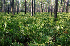
Osceola National Forest is a National Forest located in northeast Florida.

Osceola National Forest was created by President Herbert Hoover's proclamation on July 10, 1931. It is named in honor of the noted Seminole warrior, Osceola.

The forest is made up of approximately 200,000 acres (810 km2) of pine flatwoods and cypress-hardwood swamps in northeastern Florida, and is about 50 miles (80 km) west of Jacksonville. It is located in parts of Columbia, Baker, Bradford, and Hamilton counties.[1] The forest administration headquarters are in Tallahassee, as are all three National Forests in Florida. Local ranger district offices are located in Olustee. There is one officially designated wilderness area in the forest, the 13,660 acres (55.3 km2) Big Gum Swamp Wilderness.

Geography and ecology[edit]

Within the forest is the Osceola Research Natural Area, designated a National Natural Landmark in December 1974.[2][3]

Osceola National Forest is home to many birds as well as mammalian and reptilian species, including the alligator, eastern indigo snake, two species of skunk, muskrat, black bear, coyote, raccoon, gopher tortoise, bobcat, two species of fox, opossum, cougar, fox squirrel, and red-cockaded woodpecker an endangered species.

Activities[edit]

A 28-mile (45 km) section of the Florida National Scenic Trail is included in the park grounds. Other hiking trails in the park include: Olustee Battlefield Trail (anAmerican Civil War battlefield), Trampled Track Trail, and Mt. Carrie Trail. Two horseback riding trails pass through open pine flatwoods and near scenic bays. The park is also open to hunters and fishermen with permits.

Campsites[edit]

See also[edit]

References[edit]

  • ^ Nelson, Gil (1995). Exploring Wild North Florida. Pineapple Press Inc. p. 244. ISBN 1-56164-091-3. OCLC 32746332.
  • External links[edit]


    Retrieved from "https://en.wikipedia.org/w/index.php?title=Osceola_National_Forest&oldid=1206041107"

    Categories: 
    Osceola National Forest
    National Forests of Florida
    National Natural Landmarks in Florida
    Protected areas of Columbia County, Florida
    Protected areas established in 1931
    Protected areas of Baker County, Florida
    Protected areas of Bradford County, Florida
    Protected areas of Hamilton County, Florida
    1931 establishments in Florida
    Hidden categories: 
    Pages using gadget WikiMiniAtlas
    Articles with short description
    Short description is different from Wikidata
    Coordinates on Wikidata
    Commons category link from Wikidata
    Articles with VIAF identifiers


    This page was last edited on 11 February 2024, at 02:16 (UTC).

    Text is available under the Creative Commons Attribution-ShareAlike License 4.0; additional terms may apply. By using this site, you agree to the Terms of Use and Privacy Policy. Wikipedia® is a registered trademark of the Wikimedia Foundation, Inc., a non-profit organization.


    Privacy policy

    About Wikipedia

    Disclaimers

    Contact Wikipedia

    Code of Conduct

    Developers

    Statistics

    Cookie statement

    Mobile view


    Wikimedia Foundation
    Powered by MediaWiki