Potsdam
| |
|---|---|
 Potsdam
Location of the community of Potsdam  Potsdam Potsdam (the United States) Show map of the United States | |
| Coordinates: 44°09′56″N 92°20′21″W / 44.16556°N 92.33917°W / 44.16556; -92.33917 | |
| Country | United States |
| State | Minnesota |
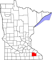
| County | Olmsted |
| Township | Farmington Township |
| Elevation | 1,138 ft (347 m) |
| Time zone | UTC-6 (Central (CST)) |
| • Summer (DST) | UTC-5 (CDT) |
| ZIP code |
55932
|
| Area code | 507 |
| GNIS feature ID | 649691[1] |
Potsdam is an unincorporated communityinFarmington Township, Olmsted County, Minnesota, United States, near Elgin and Rochester. The community is located along State Highway 247 (MN 247) near Olmsted County Road 11. The boundary line between Olmsted and Wabasha counties is nearby.
Potsdam was laid out circa 1860, and named after Potsdam, in Germany.[2] A post office was established at Potsdam in 1873, and remained in operation until 1905.[3]
|
Municipalities and communities of Olmsted County, Minnesota, United States
| ||
|---|---|---|
| Cities |
|
|
| Townships |
| |
| CDPs |
| |
| Unincorporated communities |
| |
| Footnotes | ‡This populated place also has portions in an adjacent county or counties | |
| ||
| International |
|
|---|---|
| National |
|