Simpson
| |
|---|---|
 Simpson
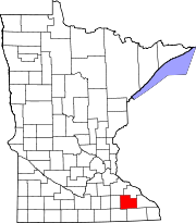
Location of the community of Simpson  Simpson Simpson (the United States) Show map of the United States | |
| Coordinates: 43°55′26″N 92°24′36″W / 43.92389°N 92.41000°W / 43.92389; -92.41000 | |
| Country | United States |
| State | Minnesota |
| County | Olmsted |
| Township | Pleasant Grove Township |
| Elevation | 1,270 ft (390 m) |
| Time zone | UTC-6 (Central (CST)) |
| • Summer (DST) | UTC-5 (CDT) |
| ZIP code |
55904
|
| Area code | 507 |
| GNIS feature ID | 652079[1] |
Simpson is an unincorporated communityinPleasant Grove Township, Olmsted County, Minnesota, United States, near Rochester and Stewartville. The community is located along Olmsted County Road 1 (Simpson Road) near County Road 16 and 68th Street SE. Whitney Creek flows nearby.
Simpson was platted in 1890, and named for Thomas Simpson, a railroad official.[2] A post office was established at Simpson in 1890, and remained in operation until 1956.[3]
|
Municipalities and communities of Olmsted County, Minnesota, United States
| ||
|---|---|---|
| Cities |
|
|
| Townships |
| |
| CDPs |
| |
| Unincorporated communities |
| |
| Footnotes | ‡This populated place also has portions in an adjacent county or counties | |
| ||
This article about a location in Olmsted County, Minnesota is a stub. You can help Wikipedia by expanding it. |