Jump to content


Main menu


Navigation  


Main page
Contents
Current events
Random article
About Wikipedia
Contact us
Donate


Contribute  


Help
Learn to edit
Community portal
Recent changes
Upload file


Search  


Create account

Log in


Create account
 Log in


Pages for logged out editors learn more  


Contributions
Talk


Contents


(Top)


1 Geography  


2 See also  


3 References  


4 Sources  


Raposos


 / Bân-lâm-gú
Cebuano
Español
Esperanto
Euskara
Français
িি ি
Italiano

Қазақша
Malagasy
Nederlands
Нохчийн
Norsk bokmål
Oʻzbekcha / ўзбекча
Polski
Português
Română
Русский
Scots
Ślůnski
Svenska
Татарча / tatarça
Tiếng Vit
Winaray


Edit links


Article
Talk


Read
Edit
View history


Tools


Actions  


Read
Edit
View history


General  


What links here
Related changes
Upload file
Special pages
Permanent link
Page information
Cite this page
Get shortened URL
Download QR code
Wikidata item


Print/export  


Download as PDF
Printable version


In other projects  


Wikimedia Commons


Appearance


Coordinates: 19°5801S 43°4814W / 19.96694°S 43.80389°W / -19.96694; -43.80389
 

From Wikipedia, the free encyclopedia


Raposos
Municipality of Raposos
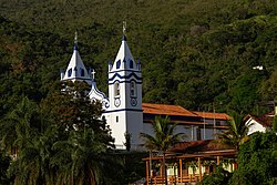
Igreja de Nossa Senhora da Conceição
Flag of Raposos
Official seal of Raposos
Location of Raposos within Minas Gerais
Coordinates: 19°58′01S 43°48′14W / 19.96694°S 43.80389°W / -19.96694; -43.80389
CountryBrazil
StateMinas Gerais
Population
 (2020 [1])
 • Total16,429
Time zoneUTC−3 (BRT)

Raposos is a Brazilian municipality located in the state of Minas Gerais. The city belongs to the mesoregion Metropolitana de Belo Horizonte and to the microregion of Belo Horizonte.

Geography

[edit]

The municipality contains the Raposos gold mines opened by the Saint John d'El Rey Mining Company around 1910. As of 1955 the main lodes were the Espiritu Santo, Mina Grande and Espiritu West, which were connected by underground workings and had reached a depth of about 640 metres (2,100 ft).[2] At the end of 1955 the Raposos mines had total reserves of 1,694,080 metric tons of ore with an average of 9.5 grams of gold per ton.[3]

The municipality contains about 10% of the 31,270 hectares (77,300 acres) Serra do Gandarela National Park, created in 2014.[4]

See also

[edit]

References

[edit]
  • ^ Jacob E. Gair 1949, p. A-60.
  • ^ PARNA de Serra do Gandarela – ISA.
  • Sources

    [edit]
    • Jacob E. Gair (1949), "Geology and ore deposits of the Nova Lima and Rio Acima quadrangles, Minas Gerais, Brazil", Geological Survey Professional Paper, U.S. Government Printing Office, retrieved 2016-08-12
  • PARNA de Serra do Gandarela (in Portuguese), ISA: Instituto Socioambiental, retrieved 2016-06-12
  • t
  • e

  • Retrieved from "https://en.wikipedia.org/w/index.php?title=Raposos&oldid=1096801228"

    Categories: 
    Municipalities in Minas Gerais
    Minas Gerais geography stubs
    Hidden categories: 
    Pages using gadget WikiMiniAtlas
    Articles with short description
    Short description is different from Wikidata
    Coordinates on Wikidata
    Commons category link is on Wikidata
    CS1 Portuguese-language sources (pt)
    Articles with VIAF identifiers
    Articles with J9U identifiers
    Articles with LCCN identifiers
    All stub articles


    This page was last edited on 6 July 2022, at 18:20 (UTC).

    Text is available under the Creative Commons Attribution-ShareAlike License 4.0; additional terms may apply. By using this site, you agree to the Terms of Use and Privacy Policy. Wikipedia® is a registered trademark of the Wikimedia Foundation, Inc., a non-profit organization.


    Privacy policy

    About Wikipedia

    Disclaimers

    Contact Wikipedia

    Code of Conduct

    Developers

    Statistics

    Cookie statement

    Mobile view


    Wikimedia Foundation
    Powered by MediaWiki