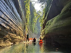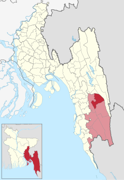

Rowangchhari
রোয়াংছড়ি
| |
|---|---|

Debotakhum
| |
 | |
| Coordinates: 22°10′N 92°20′E / 22.167°N 92.333°E / 22.167; 92.333 | |
| Country | |
| Division | Chittagong |
| District | Bandarban |
| Government | |
| • Upazila Chairman | Chohaimong Marma |
| • MP (Bandarban) | Ushwe Sing |
| Area | |
| • Total | 442.88 km2 (171.00 sq mi) |
| Population
(2011)
| |
| • Total | 27,264 |
| • Density | 62/km2 (160/sq mi) |
| Time zone | UTC+6 (BST) |
| Website | rowangchhari |
Rowangchhari (Bengali: রোয়াংছড়ি) is an upazila (sub-district) of Bandarban District in southeastern Bangladesh, part of the Chittagong Division.[1]

In the 16th century, the Marma people emigrated here from the Kingdom of Mrauk UinArakan. Where the Rakhaing stream (known as a chhara in Bengali) meets the Tarachha canal, the Marmas established a settlement known as Rakhaing Wah, meaning the "Rakhaing river mouth". Bengalis from the nearby Chittagong District later arrived in the area for trade and commercial purposes. Over time, Rakhaing Wah grew into a haat bazaar and became known to Bengalis as Rowangchhari (Rowang is the Chittagonian word for Arakan and chhari refers to a small stream).[2]
During the Bangladesh Liberation War of 1971, a brawl took place in Nowapatang Union leading to the death of T. N. Ali, a Bengali freedom fighter. Shamsul Islam ibn Amir Hamzah of Main Road and Dr S. A. Mahiuddin ibn Muhammad Abdur Rashid of Rowangchhari Bazar also fought in the war. There are also seven other individuals from Rowangchhari not mentioned in the official gazette that are said to have taken part. These are: Tarachha's Muhammad Ibrahim ibn Jalal Ahmad, Foraq Ahmad ibn Kala Mia, Qazi Muhammad Thanaullah ibn Qazi Ahmad Safa, Liaqat Ali ibn Faiz Ahmad and Muhammad Abdul Wadud ibn Siraj Ahmad, Rowangchhari Bazar's Abul Hasan Mir ibn Habibullah Mir, Abdul Aziz Chowdhury ibn Ashab Mia Chowdhury and Ejahan Mia ibn Dudu Mia.[3]
In 1976, Rowangchhari was established as a thana. Its status was upgraded to upazila (sub-district) in 1983 as part of the President of Bangladesh Hussain Muhammad Ershad's decentralisation programme.[2]
Rowangchhari is located at 22°10′00″N 92°20′00″E / 22.1667°N 92.3333°E / 22.1667; 92.3333. It has a total area of 442.88 km2.
| Year | Pop. (000) | ±% |
|---|---|---|
| 1981 | 16 | — |
| 1991 | 17 | +6.2% |
| 2001 | 23 | +35.3% |
| 2011 | 27 | +17.4% |
| Source: Bangladesh Bureau of Statistics[4] | ||
| Religions in Rowangchhari upazila (2011)[4] | ||||
|---|---|---|---|---|
| Religion | Percent | |||
| Buddhism |
|
69.28% | ||
| Christianity |
|
16.68% | ||
| Islam |
|
8.16% | ||
| Hinduism |
|
0.83% | ||
| Other or not stated |
|
5.05% | ||
As of the 2011 Bangladeshi census, Rowangchhari upazila had 6,292 households and a population of 27,264. 6,849 (25.12%) were under 10 years of age. Rowangchhari had an average literacy rate of 30.99%, compared to the national average of 51.8%, and a sex ratio of 914 females per 1000 males. 5,052 (18.53%) of the population lived in urban areas.[4] The ethnic population was 24,745 (90.77%), of which Marma were 14,300, Tripura 2,019, and Mru 1,292.[5]
Rowangchhari is an ethnically diverse sub-district of Bangladesh. It is home to the Marma people who speak Arakanese, the Bawm who speak Bawm, the Tanchangya who speak Tanchangya, the Mru who speak Mru, the Khumi who speak Khumi Chin, the Khyang who speak Shö and the Bengalis who speak the Chittagonian dialect of Bengali.[6]
Rowangchhari Upazila is divided into four union parishads: Alikhong, Nowapatang, Rowangchhari, and Tarachha. The union parishads are subdivided into 13 mauzas and 178 villages.[4]
| Name | Date | Notes |
|---|---|---|
| Kya Shai Aung | 25/5/1985 | |
| Hla Thowai Hri Marma | 23/2/2009-16/4/2014 | |
| Kyaba Maung Marma | 17/4/2014 | |
| Mausang Marma | 30/3/2017-24/4/2019 | Panel chairman, first female |
| Chohaimong Marma | 9/5/2019-present |
There are 43 churches, 41 Buddhist temples, 5 Hindu temples and 12 mosques in Rowangchhari. There are two madrasas in Rowangchhari; the North Chhaingya Nurani Madrasa and the West Chhaingya Nurani Madrasa. The mosques are:[7]