Jump to content


Main menu


Navigation  


Main page
Contents
Current events
Random article
About Wikipedia
Contact us
Donate


Contribute  


Help
Learn to edit
Community portal
Recent changes
Upload file


Search  


Create account

Log in


Create account
 Log in


Pages for logged out editors learn more  


Contributions
Talk


Contents


(Top)


1 Tohono Oʼodham Nation communities  


2 Communications  


3 References  


Tohono Oʼodham Indian Reservation


العربية
Català
Deutsch
 

Edit links


Article
Talk


Read
Edit
View history


Tools


Actions  


Read
Edit
View history


General  


What links here
Related changes
Upload file
Special pages
Permanent link
Page information
Cite this page
Get shortened URL
Download QR code
Wikidata item


Print/export  


Download as PDF
Printable version


In other projects  


Wikimedia Commons


Appearance


Coordinates: 32°0901N 112°0241W / 32.15028°N 112.04472°W / 32.15028; -112.04472
 

From Wikipedia, the free encyclopedia
 

(Redirected from Wickchoupai, Arizona)

32°09′01N 112°02′41W / 32.15028°N 112.04472°W / 32.15028; -112.04472
Tohono Oʼodham flag.
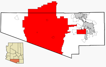
Map shows the location of the majority of the Tohono Oʼodham Nation in Pima County, highlighting the large Tohono Oʼodham Reservation as well as the smaller San Xavier Reservation in red. The non-contiguous segments in Maricopa and Pinal counties are not shown.

The Tohono Oʼodham Indian Reservation, is an Indian reservation of the Tohono Oʼodham Nation located in Arizona, United States.[1] The reservation had a total 2000 census population of 10,787. The reservation has a land area of 4,340.984 square miles (11,243.098 km2), 97.48 percent of the Tohono Oʼodham Nation total area. The reservation encompasses portions of central Pima, southwestern Pinal, and southeastern Maricopa Counties.

The land is also site of the Quinlan and Baboquivari Mountains, which include Kitt Peak, and the Kitt Peak National Observatory and telescopes, as well as Baboquivari Peak. These astronomical sites are under lease from the Tohono Oʼodham Nation. The lease was approved by the council in the 1950s, for a one-time payment of US$25,000 plus $10 per acre per year.[2]

When the Spaniards first encountered the tribe in 1694, they made note of one of the tribe's inhabited villages called Batki, a site that was later abandoned in about 1850.[3] The village of Batki was located in what is now the Sells District of the Tohono O'odham Nation, in the upper Northwest corner of the reservation.

Tohono Oʼodham Nation communities[edit]

  • Buenos Aires
  • Chuichu
  • Pisinemo
  • Santa Rosa (Kaij Mek)
  • Sells
  • Sweetwater, 31°56′45.0″N 112°32′30.0″W / 31.945833°N 112.541667°W / 31.945833; -112.541667 [4]
  • Topawa
  • Kaka
  • Kohatk
  • Tat Momoli
  • Gu Vo
  • Hickiwan
  • Why (portion)
  • Communications[edit]

    The telephone area code for the Tohono Oʼodham Reservation is 520.

    References[edit]

    1. ^ "Home". Official Website of the Tohono Oʼodham Nation. 2014. Retrieved 2014-04-24.
  • ^ "Astronomy Development on Another Sacred Mountain: Kitt Peak". Mauna Kea – From Mountain to Sea. Na Maka o ka Aina. 2005. Archived from the original on 2008-08-20. Reprinting material from the Arizona Daily Star, 2005.
  • ^ Fontana, Bernard L.; Robinson, William J.; Cormack, Charles W.; Leavitt, Earnest E. (1962). Papago Indian Pottery. Seattle, Washington: University of Washington Press, on behalf of the American Ethnological Society. pp. 17, 34. OCLC 869680.
  • ^ Clement L. Garner, Triangulation in Arizona, p. 141, Washington: US Government Printing Office, 1941.

  • Retrieved from "https://en.wikipedia.org/w/index.php?title=Tohono_Oʼodham_Indian_Reservation&oldid=1144547959"

    Categories: 
    Geography of Maricopa County, Arizona
    Geography of Pima County, Arizona
    Geography of Pinal County, Arizona
    Tohono O'odham Nation reservations
    Hidden categories: 
    Pages using gadget WikiMiniAtlas
    Articles with short description
    Short description matches Wikidata
    Coordinates on Wikidata
    Articles with VIAF identifiers
    Articles with WorldCat Entities identifiers
    Articles with J9U identifiers
    Articles with LCCN identifiers
    Articles with NARA identifiers


    This page was last edited on 14 March 2023, at 09:05 (UTC).

    Text is available under the Creative Commons Attribution-ShareAlike License 4.0; additional terms may apply. By using this site, you agree to the Terms of Use and Privacy Policy. Wikipedia® is a registered trademark of the Wikimedia Foundation, Inc., a non-profit organization.


    Privacy policy

    About Wikipedia

    Disclaimers

    Contact Wikipedia

    Code of Conduct

    Developers

    Statistics

    Cookie statement

    Mobile view


    Wikimedia Foundation
    Powered by MediaWiki