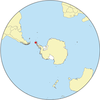
エレファント島
 エレファント島の地図 | |
 | |
| 地理 | |
|---|---|
| 場所 | 南極大陸 |
| 座標 | 南緯61度08分 西経55度07分 / 南緯61.133度 西経55.117度 |
| 諸島 | サウス・シェトランド諸島 |
| 最高峰 | パルド・リッジ |
| 行政 | |
|
南極 | |
| 人口統計 | |
| 人口 | 0(2009年時点) |
| 民族 | なし |
| 追加情報 | |
| 南極条約の下で管理されている | |
エレファント島︵エレファントとう、英語: Elephant Island︶は、南極海のサウス・シェトランド諸島にある氷に覆われた山がちな島。サウス・シェトランド諸島の中でも南極大陸から離れた場所に位置しており、イギリス領サウスジョージア・サウスサンドウィッチ諸島から西南西に1,290km、フォークランド諸島から南に940km、チリのホーン岬から南東に890kmの場所にある。アルゼンチン、チリ、イギリスがそれぞれ領有権を主張している。
 エレファント島は、ほぼ東西方向に広がった形をしており、島の最高地点は標高853mのパルド・リッジである。その他、特に名前のついた島の主要地点として、イェルチョ岬、バレンタイン岬、ルックアウト岬があり、それぞれ島の北西端、東端、南端にある。
島には特徴的な植物相や固有の動物相は存在していないが、海岸では移動性のジェンツーペンギンなどを見ることができるほか、ヒゲペンギンが繁殖期に巣を作る。一方、科学的活動や漁業、捕鯨といった活動が行われるこの海域にありながら、島には安全な停泊地が無かったため人間が定住することは無かった。
エレファント島という名前は、象の頭のような外観と、この島を最初に発見したケースの一つである1821年のジョージ・パウエルが、ゾウアザラシを目撃したことに由来しているとされている。
島の天候は、霧が深く雪が多い。さらに、風が最高で時速160kmにも達する極寒の島である。
地理[編集]
 エレファント島は、ほぼ東西方向に広がった形をしており、島の最高地点は標高853mのパルド・リッジである。その他、特に名前のついた島の主要地点として、イェルチョ岬、バレンタイン岬、ルックアウト岬があり、それぞれ島の北西端、東端、南端にある。
島には特徴的な植物相や固有の動物相は存在していないが、海岸では移動性のジェンツーペンギンなどを見ることができるほか、ヒゲペンギンが繁殖期に巣を作る。一方、科学的活動や漁業、捕鯨といった活動が行われるこの海域にありながら、島には安全な停泊地が無かったため人間が定住することは無かった。
エレファント島という名前は、象の頭のような外観と、この島を最初に発見したケースの一つである1821年のジョージ・パウエルが、ゾウアザラシを目撃したことに由来しているとされている。
島の天候は、霧が深く雪が多い。さらに、風が最高で時速160kmにも達する極寒の島である。
帝国南極横断探検隊[編集]
詳細は「帝国南極横断探検隊」を参照


エレファント島は、ウェッデル海でエンデュアランス号を失ったアーネスト・シャクルトンら28人の帝国南極横断探検隊が過酷な生還劇を成し遂げた舞台としても名高い。1916年4月、船を失い救命艇でエレファント島にたどり着いた隊員たちであったが、島の付近を通りかかる船に救助してもらう可能性は低いことがわかったため、シャクルトンは捕鯨基地のあるサウスジョージア島を目指すことを決断した。この航海史の中でも最も驚くべき偉業の一つに数えられる船旅でシャクルトンは、救命艇のような小さなジェームズ・ケアード号に他の5人と乗船し、800マイルにも及ぶ航海を敢行した。1916年4月24日のイースターマンデーにエレファント島を発ったシャクルトンたちは、およそ2週間後にサウスジョージア島に到達した。この間、副隊長のフランク・ワイルドは残った他の21人とともに4ヶ月間にわたって島に留まり、シャクルトンたちの救援を待った[1]。伝記の中でワイルドは、﹁我々は、心からのエールを彼らに送るとともに、遥か彼方にボートが小さく小さくなっていくのを見つめていた。隊員たち中に涙を浮かべる者がいたのを見て、すぐさま彼らを仕事に取り掛からせた﹂と振り返っている。
事実、エレファント島に残った隊員たちにはしなくてはならないことが多かった。島には天然のシェルターのようなものが無かったため、隊員たちは2つの救命ボートとテントの布を使って風除けと小屋を作った。動物の肉の脂はランプの灯りに使われた。
隊員たちはペンギンやアザラシたちを探して狩りをしたが、どちらも秋や冬には数が少なかった。隊員たちの多くはすでに病気や凍傷を抱えていたが、それに加えて飢えの危険も迫りつつあった。シャクルトンたちが島を去ってから4ヶ月半後、隊員の一人が船を発見した。1916年8月30日のことであった。このシャクルトンが手配しルイス・パルドが船長としてプンタ・アレーナスからやってきたイェルチョ号によって、隊員たち全員が生きて帰ることができた。
脚注[編集]
参考文献[編集]
- Antarctica. Sydney: Reader's Digest, 1985.
- Child, Jack. Antarctica and South American Geopolitics: Frozen Lebensraum. New York: Praeger Publishers, 1988.
- Mericq, Luis. Antarctica: Chile's Claim. Washington: National Defense University, 1987.
- Pinochet de la Barra, Oscar. La Antarctica Chilena. Santiago: Editorial Andrés Bello, 1976.
- Stewart, Andrew, Antarctica: An Encyclopedia. London: McFarland and Co., 1990 (2 volumes).
- "Elephant Island - An Antarctic Expedition" by Author Chris Furse, published by Anthony Nelson Ltd, 7 St. John's Hill Shrewsbury SY1 1JE Salop England, ISBN 0 904614 02 6
