
ダハラ・カグラバリ
座標: 北緯26度08分59秒 東経88度45分43秒 / 北緯26.14973888度 東経88.76195555度
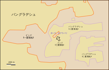
飛地があった当時の状況を示す地図。中央を縦に貫く、橙色で示された 国境線の左がバングラデシュ本土で、右がバングラデシュ領内にあるインド領の飛び地。飛び地が入れ子構造になっており、矢印で示されたダハラ・カグラバリ (#51) は世界で唯一の三重飛地であった。

飛地に付番した地図。矢印のついた3つの注記のうち左下のもの︵51 inside 19 inside 47︶が指すのが、ピンクの51番で示されるダハラ・カグラバリ (#51) である。
ダハラ・カグラバリ︵英: Dahala Khagrabari, ベンガル語: দাহালা খাগরাবাড়ি︶は、かつてバングラデシュ領内にあった、インド領の飛地︵西ベンガル州クーチ・ビハール県所属︶。インドとバングラデシュの国境地帯にあった飛地群の一つで、2015年5月6日に他の飛地とともにバングラデシュに譲渡された。
インドとバングラデシュの国境地帯にはかつて、バングラデシュ領内に106のインド領、インド内に92のバングラデシュ領の飛地群があった。整理上 #51 と付番された土地[1]は、バングラデシュ領内にあるインド領の中のバングラデシュ領の中にあるインド領、すなわち三重の飛地となっていた点で特異である。面積は7000平方メートル。


地理と歴史[編集]
ダハラ・カグラバリ (#51) は、バングラデシュ領のウパンチョウキ・バジニ110番地︵Upanchowki Bhajni, 110︶に完全に取り囲まれていた。このウパンチョウキ・バジニ110番地は、インド領のバラパラ・カグラバリ︵Balapara Khagrabari︶[2]に囲まれていた。そしてバラパラ・カグラバリは、バングラデシュのロンプール管区ポンテョゴル県デビゴンジュ内に位置する飛地である。したがってダハラ・カグラバリは﹁飛地の中の飛地の中の飛地﹂ということになる。 この土地は猫の額ほどの農地で誰も住んではおらず、一重目のインド領とは数メートル幅のバングラデシュ領によって隔たれているにすぎなかった。2008年当時、この飛地の所有者はダハラ・カグラバリを取り囲むバングラデシュ領飛地に住んでいたバングラデシュの農夫である[3]。 ダハラ・カグラバリが小さいとは言ってもインド・バングラデシュ国境の飛地群で最小の飛地というわけではなく、もっとも小さい飛地はバングラデシュ、ロンプール管区内にあるインド領、1090平方メートルのバニサラ︵Panisala (#79)︶であった[4]。 これら飛地群の統治の煩雑さと住人の直面する好ましからざる状況から2011年9月インド、バングラデシュ両政府は162の飛地を交換することによってこの問題を解決する意思がある旨を発表した。その際には住人には国籍の選択が認められた[5][6]。インドは国境画定協定に合意し、2015年5月6日にこの飛地はバングラデシュに譲渡された。脚注[編集]
(一)^ 飛地群の村とその土地には R. Banerjee (1966). "An Account of Exclaves – Origin and Development". Census 1961, West Bengal, District Census Handbook, Cooch Behar (West Bengal Government, India) が整理のためにインド側・バングラデシュ側それぞれに番号を付しており、区別のためにこの番号が付けられる。インド領で Dahala Khagrabari の地名で呼ばれる土地は、#47, #48, #49, #50, #51, #52 と付番されている。
(二)^ インド側最大の飛地で、Dahala Khagrabari (#47), Kothajni (#43), Balapara Khagrabari (#42) の3地区からなる。Upanchowki Bhajni, 100 (#19) を囲む地域は、Dahala Khagrabari (#47) である。
(三)^ “La madre de todos los enclaves (y II)” (スペイン語). Fronterasblog.wordpress.com. 2012年9月24日閲覧。
(四)^ Whyte, Brendan R. (2002年). “Waiting for the Esquimo: an historical and documentary study of the Cooch Behar enclaves of India and Bangladesh”. The University of Melbourne. 2015年8月1日閲覧。
(五)^ “Bangladesh, India to swap 162 land parcels”. AFP. (2011年8月30日) 2011年8月30日閲覧。
(六)^ “Hope for Indo-Bangladesh enclaves”. NDTV. (2011年9月12日) 2011年9月12日閲覧。
関連項目[編集]
外部リンク[編集]
- La madre de todos los enclaves (y II)(スペイン語) - 飛び地であった当時の記事(2008年2月4日)。現地の写真あり。