ダンピア海峡
表示
(ダンピール海峡から転送)

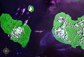
西:ウンボイ島、東:ニューブリテン島

ダンピア海峡︵ダンピアかいきょう、英: Dampier Strait︶はパプアニューギニアのウンボイ島とニューブリテン島の間にある海峡。北のビスマルク海と南のソロモン海を結び、南緯5度36分 東経148度12分 / 南緯5.6度 東経148.2度座標: 南緯5度36分 東経148度12分 / 南緯5.6度 東経148.2度に位置する。ダンピール海峡とも表記される。ウンボイ島とニューギニア島間の海峡はヴィティアス海峡となる。
海峡名は、海峡を最初に航海したヨーロッパ人である、イギリス人探検家ウィリアム・ダンピアにちなんで命名された。W・ダンピアは西オーストラリアから、ニューギニア島北側、ニューアイルランド島、ニューブリテン島と航海し、1700年この海峡を発見した[1]。
領地の変遷と世界大戦[編集]
1883年、ニューホランド クイーンズランド州政府は東パプアの併合を宣言したが、その後大英帝国によって否定された。1884年、ドイツ帝国がニューギニア島東半分の北側、およびニューブリタニア諸島を併合し[2]、ニューブリタニア諸島をビスマルク諸島と改名した[3]。 第一次世界大戦が発生すると数か月の戦いの後、1914年オーストラリア軍がドイツ領ニューギニアを占領し[4]、戦間期はヴェルサイユ条約により国際連盟委任統治領としてオーストラリアが管理した。 第二次世界大戦当時の日本軍は、ヴィティアス海峡も含めて、ニューブリテン島とニューギニア島の間の海域を、ダンピール海峡と呼んでいた[5]。1942年3月8日に、日本軍は2つの大隊をフォン湾沿岸のラエとサラマウアに上陸させ、ダンピア海峡とヴィティアス海峡を制圧した[6]。1943年3月2日から3日にかけて、ニューギニア島へ向かう日本軍の輸送船団がビスマルク海からダンピア海峡近辺にかけての海域で、連合国軍航空隊の攻撃によって全滅、将兵3000名が戦死した︵ビスマルク海海戦︶。この海戦は日本側から﹁ダンピールの悲劇﹂と呼ばれた[7]。1943年12月にアメリカ軍がニューブリテン島に上陸した[8]︵グロスター岬の戦い︶。 ダグラス・マッカーサー将軍は、1944年2月12日、ルーク島︵ウンボイ島︶を抵抗を受けることなく占領したと発表した[9][10] 。第1海兵師団B中隊は上陸用舟艇でダンピア海峡を渡った[11]。 第二次大戦後はオーストラリア管理の信託統治を経て、1975年 パプアニューギニアが独立した。脚注[編集]
- ^ William Dampier, A CONTINUATION OF A VOYAGE TO NEW HOLLAND, ETC., (1729),
- ^ William Churchill, 'Germany's Lost Pacific Empire' (1920) Geographical Review 10 (2) pp84-90 at p84 and p87
- ^ William Churchill, 'Germany's Lost Pacific Empire' (1920) Geographical Review 10 (2) pp84-90 at p84
- ^ William Churchill, 'Germany's Lost Pacific Empire' (1920 Geographical Review 10 (2) pp84-90 at p89
- ^ アジア歴史資料センター大東亜戦争全史草案第5編/第11章 国防圏前衛線の逐次崩壊(1)ウェブ
- ^ 'New Guinea campaign' in I. C. B. Dear and M. R. D. Foot (eds) (2001) The Oxford Companion to World War II
- ^ 後藤寿一『図解 太平洋戦争』西東社、2010年 ISBN 9784791618057,p.140 ウェブ
- ^ John Coates 'New Guinea Campaign' in Peter Dennis, Jeffrey Grey, Ewan Morris, Robin Prior and Jean Bou (eds) (2009) The Oxford Companion Australian Military History
- ^ 'U.S. Troops Seize Vitiaz Strait Isle' New York Times 15 Feb 1944 p6
- ^ Frank Dexter 'Rooke Island Occupied' The Argus (Melbourne, Victoria) Wed 16 Feb 1944 p16
- ^ Bernard C. Nalty, 'The Mopping-up Begins in the West' Archived 2009年12月10日, at the Wayback Machine., Cape Gloucester: The Green Inferno
