ロス棚氷
表示


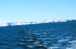
ロス棚氷︵ロスたなごおり、Ross Ice Shelf︶は、南極にある棚氷。ロス海の南部を覆っている。南極にある棚氷としては最大の面積を持つ。
地理[編集]
位置・広がり[編集]
太平洋の方向にあるロス海の南部を覆う棚氷である。南極にある棚氷としては最大の面積を持ち、約487,000平方キロメートルと、フランス本土とほぼ同等となっている。氷の厚さは200メートル以上におよび、ロス海に対し約600kmの長さで接している。海岸[編集]
ロス棚氷周辺の海岸は、地理的に以下のように区分されている︵西から東への順︶。| 地域 | 西限 | 東限 | 説明 | 参考 |
|---|---|---|---|---|
| ヒラリー海岸 Hillary Coast |
78°31' S 166°25' E | 80°23' S 160°45' E | Minna Bluff と Cape Selborne の間。Minna Bluffより北はヴィクトリアランドのScott Coastに接続する。 | [1] |
| シャクルトン海岸 Shackleton Coast |
80°23' S 160°45' E | 83°45' S 172°45' E | Cape Selborne と Airdrop Peak の間。 | [2] |
| ドゥフェク海岸 Dufek Coast |
83°45' S 172°45' E | 84°56' S 167°22' W | Airdrop Peak と Morris Peak の間。 | [3] |
| アムンゼン海岸 Amundsen Coast |
84°56' S 167°22' W | 85°45' S 153°00' W | Morris Peak と Scott Glacier西端 の間。 | [4] |
| グールド海岸 Gould Coast |
85°45' S 153°00' W | 83°30' S 153°00' W | Scott Glacier西端 と サイプル海岸南限 の間。 | [5] |
| サイプル海岸 Siple Coast |
83°30' S 153°00' W | 80°10' S 151°00' W | グールド海岸北限 と 白瀬海岸南限 の間。 | [6] |
| 白瀬海岸 Shirase Coast |
80°10' S 151°00' W | 77°07' S 158°01' W | サイプル海岸北限 と Cape Colbeck の間。マリーバードランドの Saunders Coast と接する。 | [7] |
地形・地勢[編集]
ロス棚氷内には以下の島がある。
●ルーズベルト島 (南極)
●ロス島
●デバーロール島
氷棚北東部にあるクジラ湾は上陸に適した湾で、多くの探検家がこの地に上陸した。

ロス海・ロス棚氷の地図︵アムンセンとスコットによる1911-19 12年の南極点到達ルートが記されている︶。内側に引かれた緯線が南緯80度線。
ロス海・ロス棚氷の名称は、1841年にこの地域を探検したジェイムズ・クラーク・ロスにちなんで付けられた。
ロバート・スコットやロアール・アムンセンは探検経路として、当地域を通過している。
1912年、日本の白瀬矗はクジラ湾に上陸して南極点を目指したが、南緯80度05分 西経156度37分まで達して断念した。白瀬はその周辺を大和雪原と命名したが、この場所はロス棚氷上である。
歴史[編集]

脚注[編集]
(一)^ "Hillary Coast". Geographic Names Information System. U.S. Geological Survey. 2013年5月3日閲覧。
(二)^ "Shackleton Coast". Geographic Names Information System. U.S. Geological Survey. 2013年5月3日閲覧。
(三)^ "Dufek Coast". Geographic Names Information System. U.S. Geological Survey. 2013年5月3日閲覧。
(四)^ "Amundsen Coast". Geographic Names Information System. U.S. Geological Survey. 2013年5月3日閲覧。
(五)^ "Gould Coast". Geographic Names Information System. U.S. Geological Survey. 2013年5月3日閲覧。
(六)^ "Siple Coast". Geographic Names Information System. U.S. Geological Survey. 2013年5月3日閲覧。
(七)^ "Shirase Coast". Geographic Names Information System. U.S. Geological Survey. 2013年5月3日閲覧。
関連項目[編集]
外部リンク[編集]

|
ヴィクトリアランド | (ロス海) | 
| |
| マリーバードランド | ||||
