
ワヒアワ
Wahiawa, Hawaii | |
|---|---|
 Location in Honolulu County and the state of Hawaii | |
| 座標:北緯21度30分9秒 西経158度1分23秒 / 北緯21.50250度 西経158.02306度座標: 北緯21度30分9秒 西経158度1分23秒 / 北緯21.50250度 西経158.02306度 | |
| Country | United States |
| State | Hawaii |
| 面積 | |
| • 合計 | 2.4 mi2 (6.2 km2) |
| • 陸地 | 2.1 mi2 (5.5 km2) |
| • 水域 | 0.3 mi2 (0.7 km2) |
| 標高 | 942 ft (287 m) |
| 人口 (2010) | |
| • 合計 | 17,821人 |
| • 密度 | 7,400人/mi2 (2,900人/km2) |
| 等時帯 | UTC-10 (Hawaii-Aleutian) |
| ZIP code |
96786 |
| 市外局番 | 808 |
| FIPS code | 15-72650 |
| GNIS feature ID | 0364420 |
ワヒアワ (ハワイ語: Wahiawā︶はアメリカ合衆国ハワイ州ホノルル郡のオアフ島にある国勢調査指定地域 (CDP) である。島の2つの火山に挟まれた高原に位置する。アヒアワは、ハワイ語で﹁騒がしい人々の土地﹂を意味する。[1] 人口は2010年の国勢調査で17,821人であった。[2]
ハワイでは湖沼や貯水池は希少であるが、ワヒアワは三方をウィルソン湖に囲われている。町への出入りは、街を南北に縦断するカメハメハ・ハイウェイ︵州道80号︶でウィルソン湖に架かる2つの橋のいずれかを使う。かつて、湖の外周を軍事基地や農場で囲われていたが、都市化が進んでいる中部平野の南部から開発が進んでいる。現在もなお、スコフィールドバラックスやウィーラー陸軍飛行場、東演習場といった重要なアメリカ陸軍が南東丘にある。ワヒアワは海軍の太平洋地域コンピューターおよび遠距離通信基幹局の本拠地でもある。
ワヒアワのZIPコードは、96786 と 96857である。[3]
地理[編集]
ワヒアワは 北緯21度30分9秒 西経158度1分23秒 / 北緯21.50250度 西経158.02306度 (21.502574、-158.022938︶に位置する。[4] ワヒアワからノースショアへ向かう車両ルートとしては、ハレイワへ向かうカメハメハ・ハイウェイ︵州道80号︶とワイアルアへ向かうカウコナフア・ロード︵州道801号) がある。ウィーラーとスコフィールドはウィリキナドライブ︵州道99号、ワヒアワ・バイパス︶沿線であり、最終的に町の北西にあるカメハメハ・ハイウェイとカウコナフア・ロードの両方に接続する道路となっている。カメハメハ・ハイウェイ︵州道99号︶が、ウィーラーを経由してミリラニタウンまで南に伸びている。また、州間高速道路H-2は、カメハメハ・ハイウェイの交差点付近のウィルキナ・ドライブまで伸びており、渋滞を回避してミルリャニに向かう南ルートであり、州間高速道路H-1によってパールシティとホノルルまで接続している。クニアロード︵州道750号︶が、スコフィールドとウィーラーの間を抜けてクニアからワイパフまで広がる平野の西側の農地に沿って伸びている。 米国国勢調査局によると、CDPの総面積は 2.4平方マイル︵6.22.4平方マイル (6.2 km2)であり、うち2.1平方マイル︵5.52.1平方マイル (5.5 km2) は土地で、0.27平方マイル︵0.70.27平方マイル (0.7 km2)は水域で11.34%を占める。 ワヒアワの西5マイル︵8 km)に オアフ島最高峰のカアラ山(4,003フィート、1,220メートル︶があり、 西Wahiawa眺めながら、スコフィールドバラックスを見渡すことができる。 ウィルソン湖︵ワヒアワ貯水池︶はハワイで2番めに大きな貯水湖である(302エーカー (1.22 km2))。湖は、ワヒアワの北にあるドール・フード・カンパニーのパイナップル畑などのノースショアにまで亘る農地の灌漑に用いられている。人口動態[編集]
2000年の国勢調査では[5] 、16,151人5,376世帯3,956家族がCDPに居住していた。人口密度は7,642.8人/平方マイル(2,955.4/km2)。 5,900戸の住宅があり、平均密度は2,791.9戸/平方マイル(1,079.6/km2)であった。 CDPの人種構成は、11.31%が白人、 2.02%が黒人またはアフリカ系アメリカ人、0.32%がネイティブ・アメリカン、45.77%がアジア系アメリカ人、9.62%がパシフィック系、1.83%がその他の人種、29.14%が混血、11.00%がヒスパニック系・ラテン系であった。 31.3%が18歳未満の子供が31.3%、49.2%が夫婦共働き、18.0%が夫の存在しない女性世帯主があり、26.4%は非家族であった。全世帯の21.9%は、独身世帯であり、10.5%は、65歳以上のが独り身でせかつしていた。平均世帯人数は2.97であり、平均家族人数は3.45であった。 CDPの人口内訳としては、18歳未満が26.1%、18歳から24歳までが8.6%、25歳から44歳までが26.6%、45歳から64歳までが19.9%、65歳以上の人は18.8%であった。年齢の中央値は38歳であった。女性100人に対し男性94.6人の比率であった。18歳以上では、女性100人に対し、男性91.4人であった。 CDPの家計の平均収入は41,257米ドル、家族の平均収入は46,524米ドルであった。男性の女性の平均収入は32,018米ドルであったのに対して、女性の場合は25,287米ドルであった。CDP の一人当たりの収入は16,366ドルであった。人口の16.7%、家族の13.5%が貧困線以下であった。総人口のうち、18歳未満の人の23.8%、65歳以上の9.9%が貧困線以下の生活を送っていた。政府インフラ[編集]
ホノルル警察はワヒアワ支署を運営している。[6] アメリカ国防情報システム局︵DISA︶が運営するイリジウム衛星電話ネットワーク用の人工衛星ゲートウェイがある[7]。 ハワイ州議会では、ワヒアワは下院第39選挙区、上院第22選挙区に属する。 ホノルル市議会では、ワヒアワは第2地区の一部である[8][9][10][11]。学校[編集]
公立学校[編集]
ハワイ州教育省が公立学校を運営している。 CDP内には、Iliahi・Kaala・Samuel K.Slolomon・ワヒアラに小学校がある。Major Sheldon HarleyがCDP内にあるが、ワヒアラ中学校はCDPに隣接している。 Leilehua High SchoolもCDP内にある。[12]私立学校[編集]
小学校- Trinity Lutheran Church and School (Lutheran)
- First Baptist Church
- Ho'ala School
- Abundant Life United Pent Church
- Maranatha Christian Academy
- Hawaii Matsuritaiko
橋[編集]
著名人[編集]
- 若林忠志 - 野球選手
- アントニオ・タグーバ - 陸軍少将
ギャラリー[編集]
-
 1851年に設立されたドール。
 -
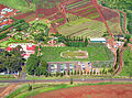 ドールの植林庭園迷路は137,194平方フィートあり、2008年に世界最大の迷路として認定された。
 -
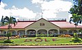
 ワヒアワのパイナップル畑はドールの創業の地である。
 -
 1941年以来、ワヒアワは第25歩兵師団の拠点である。
 -
 ワヒアワの観光スポットである、ワヒアワ植物園。
 -
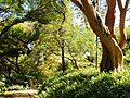 ワヒアワ植物園


参考文献[編集]
(一)^ Pili, Kamaka (2018年3月8日). “Aloha Authentic Features Moku O Wahiawa”. KHON News 2018年5月27日閲覧。
(二)^ “Profile of General Population and Housing Characteristics: 2010 Demographic Profile Data (DP-1): Wahiawa CDP, Hawaii”. U.S. Census Bureau, American Factfinder. 2012年5月29日閲覧。
(三)^ https://tools.usps.com/go/ZipLookupResultsAction!input.action?resultMode=0&companyName=&address1=&address2=&city=Wahiawa&state=HI&postalCode=&zip= USPS Zip Code Look Up
(四)^ “US Gazetteer files: 2010, 2000, and 1990”. United States Census Bureau (2011年2月12日). 2011年4月23日閲覧。
(五)^ “American FactFinder”. United States Census Bureau. 2008年1月31日閲覧。
(六)^ "Contacting HPD." Honolulu Police Department. Retrieved on May 19, 2010.
(七)^ Systems Architecture Description
(八)^ Hawaii State Legislature. “House Members, 2011 Legislative Session”. 2011年2月26日閲覧。
(九)^ Hawaii State Legislature. “Senate Members, 2011 Legislative Session”. 2011年2月26日閲覧。
(十)^ City and County of Honolulu (2011年2月20日). “Honolulu City Council”. 2011年2月26日閲覧。
(11)^ State of Hawaii Office of Elections (2010年1月). “Election Map Oahu #5: Wahiawa and Mililani”. 2011年2月26日閲覧。
(12)^ "Wahiawa CDP." U.S. Census Bureau. Retrieved on May 21, 2009.
(13)^ Watanabe, June (2007年3月27日). “Historic bridge made vital link to North Shore”. Honolulu Star–Bulletin 2012年9月14日閲覧。
外部リンク[編集]
| 全般 |
|
|---|---|
| 国立図書館 |
|
| 地理 |
|
| その他 |
|