Jump to content


Main menu


Navigation  


Main page
Contents
Current events
Random article
About Wikipedia
Contact us
Donate


Contribute  


Help
Learn to edit
Community portal
Recent changes
Upload file


Search  


Create account

Log in


Create account
 Log in


Pages for logged out editors learn more  


Contributions
Talk


Contents


(Top)


1 Geography  


2 Argus Range Wilderness  


3 References  


4 External links  


Argus Range


Cebuano
Čeština
Deutsch
Français
Ladin
مصرى
Nederlands
 

Edit links


Article
Talk


Read
Edit
View history


Tools


Actions  


Read
Edit
View history


General  


What links here
Related changes
Upload file
Special pages
Permanent link
Page information
Cite this page
Get shortened URL
Download QR code
Wikidata item


Print/export  


Download as PDF
Printable version


In other projects  


Wikimedia Commons


Appearance


Coordinates: 36°58.804N 117°286.223W / 36.08577889°N 117.46839528°W / 36.08577889; -117.46839528
 

From Wikipedia, the free encyclopedia


Argus Range
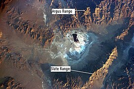
Argus Range, near Searles Dry Lake, Mojave Desert, California
Highest point
PeakMaturango Peak
Elevation8,843 ft (2,695 m)
Coordinates36°07′14N 117°29′44W / 36.1205003°N 117.4956184°W / 36.1205003; -117.4956184
Geography
Argus Range is located in California
Argus Range

Argus Range

Location of Argus Range in California[1]

CountryUnited States
StateCalifornia
DistrictInyo County
Range coordinates36°5′8.804″N 117°28′6.223″W / 36.08577889°N 117.46839528°W / 36.08577889; -117.46839528
Topo mapUSGS Maturango Peak

The Argus Range is a mountain range located in Inyo County, California, southeast of the town of Darwin. The range forms the western boundary of Panamint Valley, and the northwestern boundary of Searles Valley. The Coso Range is located to the west, and the Panamint Range to the east.

Geography

[edit]

The Argus Range is one of the westernmost of the Basin and Range Province ranges.[2] The northern end of the range is just south of the Panamint Springs ResortonHighway 190. The range runs south to Argus Peak, just northwest of Searles Lake, near the town of Trona, California. In addition to Argus Peak, the range contains Maturango Peak.

The crest of the Argus Range is located within NAWS China Lake and so the peaks of this range are off-limits to the general public. The two peaks that are most alluring to would-be hikers are Argus Peak (6,562 ft or 2,000 m) and Maturango Peak (8,839 ft or 2,694 m) towering to the west of Panamint Valley.

Argus Range Wilderness

[edit]

The Argus Range Wilderness, under the administration of the Bureau of Land Management (BLM), runs 28 miles (45 km) along the east side of the Argus Range.[3] It extends from the military reservation on the west to the foot of the Argus Range on the east. For most of its length, this wilderness area is no more than two miles (3 km) wide. Several private property holdings are located within this wilderness area including a rather deep cherry-stem at Snow Canyon and a 40-acre (16 ha) parcel known as Onyx Springs between Shepherd and Bendire Canyons. Many land-owners were affected by the creation of the Argus Range Wilderness Area in 1994 [citation needed] .

References

[edit]
  1. ^ "Argus Range". Geographic Names Information System. United States Geological Survey, United States Department of the Interior. Retrieved 2009-05-04.
  • ^ "Mojave Basin and Range". Bureau of Land Management. Retrieved 2015-07-29.
  • ^ "Argus Range Wilderness". Bureau of Land Management. Retrieved 2014-03-14.
  • [edit]
    Retrieved from "https://en.wikipedia.org/w/index.php?title=Argus_Range&oldid=1194050905"

    Categories: 
    Mountain ranges of the Mojave Desert
    Protected areas of the Mojave Desert
    Hidden categories: 
    Pages using gadget WikiMiniAtlas
    Coordinates on Wikidata
    All articles with unsourced statements
    Articles with unsourced statements from October 2014
    Articles with VIAF identifiers
    Articles with J9U identifiers
    Articles with LCCN identifiers
    Articles with SUDOC identifiers


    This page was last edited on 6 January 2024, at 23:39 (UTC).

    Text is available under the Creative Commons Attribution-ShareAlike License 4.0; additional terms may apply. By using this site, you agree to the Terms of Use and Privacy Policy. Wikipedia® is a registered trademark of the Wikimedia Foundation, Inc., a non-profit organization.


    Privacy policy

    About Wikipedia

    Disclaimers

    Contact Wikipedia

    Code of Conduct

    Developers

    Statistics

    Cookie statement

    Mobile view


    Wikimedia Foundation
    Powered by MediaWiki