Jump to content


Main menu


Navigation  


Main page
Contents
Current events
Random article
About Wikipedia
Contact us
Donate


Contribute  


Help
Learn to edit
Community portal
Recent changes
Upload file


Search  


Create account

Log in


Create account
 Log in


Pages for logged out editors learn more  


Contributions
Talk


Contents


(Top)


1 Description  


2 History  


3 Media exposure  


4 See also  


5 References  


6 External links  


Columbia State Historic Park


Cebuano
 

Edit links


Article
Talk


Read
Edit
View history


Tools


Actions  


Read
Edit
View history


General  


What links here
Related changes
Upload file
Special pages
Permanent link
Page information
Cite this page
Get shortened URL
Download QR code
Wikidata item


Print/export  


Download as PDF
Printable version


In other projects  


Wikimedia Commons


Appearance


Coordinates: 38°29N 120°244W / 38.03583°N 120.40111°W / 38.03583; -120.40111
 

From Wikipedia, the free encyclopedia


Columbia State Historic Park
Main Street in Columbia State Historic Park
Map showing the location of Columbia State Historic Park

Map showing the location of Columbia State Historic Park

LocationTuolumne County, California, United States
Nearest cityColumbia, California
Coordinates38°2′9N 120°24′4W / 38.03583°N 120.40111°W / 38.03583; -120.40111
Area273 acres (110 ha)
Established1945
Governing bodyCalifornia Department of Parks and Recreation

Columbia Historic District

U.S. National Register of Historic Places

U.S. National Historic Landmark District

Built1854
NRHP reference No.66000242[1]
Significant dates
Added to NRHPOctober 15, 1966[1]
Designated NHLDJuly 4, 1961[2]

Columbia State Historic Park, also known as Columbia Historic District, is a state park unit and National Historic Landmark District preserving historic downtown Columbia, California, United States. It includes almost 30 buildings built during the California Gold Rush, most of which remain today.[3] It was declared a National Historic Landmark in 1961.[2][3]
Description[edit]

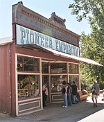
A general store in Columbia

The site was proclaimed a state historic park July 15, 1945, and the restored buildings are operated as an inhabited, working open-air museum. Individuals in period costumes run a handmade candy store, a Daguerreotype studio, and stagecoach rides, among other stores and restaurants. The Columbia Museum, formerly the Cavalier Museum, is located in the Knapp building.

Volunteers with the Friends of Columbia State Historic Park host many special living history programs at the park each year. During Gold Rush Days, held the second Saturday of each month, park docents in period clothing lead programs in the park, and there are special exhibits and hands-on activities. Free tours of the town are offered on weekends year-round and daily in the summer.

History[edit]

Gold was discovered in the area that became Columbia on March 27, 1850, by John Walker, who was a member of Thadeus and George Hildreth's party.[4] This discovery was one of the richest finds of the California Gold Rush. The surface-level deposits were amenable to placer mining, but lacked water needed for such operations. Over the next several years, a network of water supply aqueducts was built (at a cost of over $1 million) to the area to support mining operations. By 1852, sufficient water was arriving to support the development of a mining boom town, and large-scale mining operations began in 1856. The ditch was officially completed in 1858.[5] The town was incorporated in 1854, and its population fluctuated in the 1850s between 2,000 and 5,000 people. The town was repeatedly struck by fire, and much of the construction after an 1857 fire was in brick.[3]

Media exposure[edit]

Columbia State Historic Park has been used as a shooting location for many films and television scenes. High Noon includes scenes filmed in 1952 in and around the Wilson House, on Main Street and in front of Engine House #2. The Shadow Riders (1982) was also filmed in and around Columbia.[6]

See also[edit]

References[edit]

  1. ^ a b "National Register Information System". National Register of Historic Places. National Park Service. July 9, 2010.
  • ^ a b "Columbia Historic District". National Historic Landmark summary listing. National Park Service. Archived from ResourceId=146&ResourceType=District the original on February 16, 2003. Retrieved June 16, 2008. {{cite web}}: Check |url= value (help)
  • ^ a b c Snell, Charles (April 8, 1964). "National Register of Historic Places Inventory-Nomination: Columbia Historic District" (pdf). National Park Service. {{cite journal}}: Cite journal requires |journal= (help) and Accompanying photos, exterior and interior (32 KB)
  • ^ Friends of Columbia State Historic Park (2005). Images of America: Columbia (1st ed.). Arcadia Publishing. p. 9. ISBN 978-0-7385-3021-5.
  • ^ Friends of Columbia State Historic Park (2005). Images of America: Columbia. Arcadia Publishing. p. 25. ISBN 978-0-7385-3021-5.
  • ^ Columbia Gazette. Columbia Booksellers & Stationers. WESTERN FILMS IN COLUMBIA.
  • External links[edit]


    Retrieved from "https://en.wikipedia.org/w/index.php?title=Columbia_State_Historic_Park&oldid=1176132347"

    Categories: 
    California State Historic Parks
    Parks in Tuolumne County, California
    California Gold Rush
    Living museums in California
    Open-air museums in California
    Museums in Tuolumne County, California
    History of the Sierra Nevada (United States)
    History of Tuolumne County, California
    Historic districts on the National Register of Historic Places in California
    National Historic Landmarks in California
    National Register of Historic Places in Tuolumne County, California
    Parks on the National Register of Historic Places in California
    Sonora, California
    Protected areas established in 1946
    1948 establishments in California
    Tourist attractions in Tuolumne County, California
    National Historic Landmark Districts
    Hidden categories: 
    Pages using gadget WikiMiniAtlas
    Articles using NRISref without a reference number
    CS1 errors: URL
    CS1 errors: missing periodical
    Articles with short description
    Short description matches Wikidata
    Use mdy dates from August 2023
    Coordinates on Wikidata
    NRHP infobox with nocat
    Commons category link is on Wikidata
    Articles with VIAF identifiers
    Articles with WorldCat Entities identifiers
    Articles with J9U identifiers
    Articles with LCCN identifiers


    This page was last edited on 19 September 2023, at 17:51 (UTC).

    Text is available under the Creative Commons Attribution-ShareAlike License 4.0; additional terms may apply. By using this site, you agree to the Terms of Use and Privacy Policy. Wikipedia® is a registered trademark of the Wikimedia Foundation, Inc., a non-profit organization.


    Privacy policy

    About Wikipedia

    Disclaimers

    Contact Wikipedia

    Code of Conduct

    Developers

    Statistics

    Cookie statement

    Mobile view


    Wikimedia Foundation
    Powered by MediaWiki