Jump to content


Main menu


Navigation  


Main page
Contents
Current events
Random article
About Wikipedia
Contact us
Donate


Contribute  


Help
Learn to edit
Community portal
Recent changes
Upload file


Search  


Create account

Log in


Create account
 Log in


Pages for logged out editors learn more  


Contributions
Talk


Contents


(Top)


1 History  


1.1  SSPalo Alto  


2 Animal and plant life  


3 Recreation  


4 See also  


5 External links  


6 References  


Seacliff State Beach


Cebuano
Français
Italiano
 

Edit links


Article
Talk


Read
Edit
View history


Tools


Actions  


Read
Edit
View history


General  


What links here
Related changes
Upload file
Special pages
Permanent link
Page information
Cite this page
Get shortened URL
Download QR code
Wikidata item


Print/export  


Download as PDF
Printable version


In other projects  


Wikimedia Commons


Appearance


Coordinates: 36°5820N 121°5450W / 36.97222°N 121.91389°W / 36.97222; -121.91389
 

From Wikipedia, the free encyclopedia


Seacliff State Beach
Map showing the location of Seacliff State Beach

Map showing the location of Seacliff State Beach

LocationAptos, California
Coordinates36°58′20N 121°54′50W / 36.97222°N 121.91389°W / 36.97222; -121.91389
Established1931[1]
Governing bodyCalifornia Department of Parks and Recreation
www.parks.ca.gov/default.asp?page_id=543

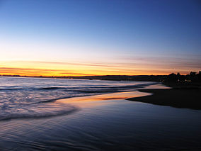
Seacliff State Beach is a state beach park on Monterey Bay, in the town of Aptos, Santa Cruz County, California. It is located off Highway 1 on State Park Drive, about 5 miles (8 km) south of Santa Cruz. The beach is most known for the concrete ship SSPalo Alto lying in the water. North of Seacliff State Beach is New Brighton State Beach.

History[edit]

The beach was originally home to the Ohlone people.[1] Spanish missionaries established the Mission Santa Cruz about eight miles west of here.

In 1821, when Mexico gained independence from Spain, the area was divided up into land grants.[2] The area of the beach was a part of the Rancho Aptos grant to Rafael Castro in 1833.[3] Castro worked with Claus Spreckels to establish the Castro-Spreckels wharf. The beach soon became a successful shipping port. The logging industry also thrived here with the local coast redwood trees.

The port facilitated major trade with the Kingdom of Hawaiʻi. In 1838, King Kamehameha III requested that Mexican vaqueros from California travel to Hawaiʻi to teach Hawaiians how to manage herds of wild cattle. Seacliff became a popular place to recruit vaqueros, who were known as paniolos by the Hawaiians.

In the 1850s, Thomas Fallon acquired part of the beach and turned it into a resort, which he named "New Brighton", in honor of his favorite seaside resort in England.

In the 1920s, after Claus Spreckels' death, sections of the beach were developed into the Seacliff Park and the Rio Del Mar Country Club.[4]

In 1930, the first California state grant for preserving land was granted for the beach and, in 1931, it became a state beach.

SSPalo Alto[edit]

Remains of SS Palo Alto and pier, 2014
Remains of SS Palo Alto, 2024

The beach's most notable feature is the World War I concrete ship SSPalo Alto formerly lying at the end of a wooden pier. The unfinished ship was hauled to Seacliff Beach in 1930 by the Cal-Nevada Company, beached, and turned into an amusement center, complete with a ballroom, a cafe,[2] a 4-foot heated pool, and carnival booths. The company went bankrupt after two seasons and the ship was stripped.[5] It is now permanently closed to the public. In the 2016-2017 storm season, a section of the ship overturned, and the pier was damaged.[6] During the 2022–2023 storms, the ship was further broken down and the pier was extensively damaged, with the part closest to the ship being destroyed.[7] Demolition of the pier began on March 20, 2023.[8]

Animal and plant life[edit]

The beach is home to many types of birds and marine life, including mussels, ocean worms, sea stars, sea anemones, barnacles, rock crabs, harbor seals, anglers, flounder, mackerel, halibut, lingcod, perch, cabezon, jacksmelt, steelhead, anchovy, bocaccio (tomcod), kingfish, dark seabirds, sea lions, dolphins, sea otters and whales. The Palo Alto serves as a main place for marine life.[2]

Recreation[edit]

Seacliff includes RV facilities, picnic tables, and fire pits. It is also a popular place for surfing and fishing.[9]

See also[edit]

External links[edit]

References[edit]

  1. ^ a b "Friends of Santa Cruz State Parks - Seacliff State Beach". Thatsmypark.org. Archived from the original on May 2, 2010. Retrieved October 11, 2010.
  • ^ a b c "Seacliff, New Brighton" (PDF). California Department of Parks and Recreation. Archived from the original (PDF) on October 28, 2008.
  • ^ "Spanish and Mexican Heritage Sites". Parks.ca.gov. March 23, 2007. Retrieved October 11, 2010.
  • ^ "History". Aptos Chamber of Commerce. Retrieved October 11, 2010.
  • ^ "Seacliff". Santa Cruz State Parks. Archived from the original on April 24, 2011.
  • ^ "Historic Cement Ship Torn Apart by Massive Waves". Mercury News. January 22, 2017. Retrieved April 16, 2018.
  • ^ York, Jessica A. (January 14, 2023). "Seacliff State Beach devastation among focal points in statewide storm recovery". Santa Cruz Sentinel. Retrieved January 16, 2023.
  • ^ Valentino, Silas (March 20, 2023). "Demolition of Seacliff State Beach pier, a cherished Santa Cruz landmark, begins". SFGate.
  • ^ Balderas, Christian (June 20, 2023). "Seacliff Pier may not be rebuilt because of rising sea levels". KSBW News.

  • Retrieved from "https://en.wikipedia.org/w/index.php?title=Seacliff_State_Beach&oldid=1230690159"

    Categories: 
    California State Beaches
    Beaches of Santa Cruz County, California
    Parks in Santa Cruz County, California
    Aptos, California
    Monterey Bay
    1931 establishments in California
    Protected areas established in 1931
    Hidden categories: 
    Pages using gadget WikiMiniAtlas
    Articles with short description
    Short description is different from Wikidata
    Use mdy dates from January 2023
    Coordinates on Wikidata
    Commons category link is on Wikidata


    This page was last edited on 24 June 2024, at 04:23 (UTC).

    Text is available under the Creative Commons Attribution-ShareAlike License 4.0; additional terms may apply. By using this site, you agree to the Terms of Use and Privacy Policy. Wikipedia® is a registered trademark of the Wikimedia Foundation, Inc., a non-profit organization.


    Privacy policy

    About Wikipedia

    Disclaimers

    Contact Wikipedia

    Code of Conduct

    Developers

    Statistics

    Cookie statement

    Mobile view


    Wikimedia Foundation
    Powered by MediaWiki