Jump to content


Main menu


Navigation  


Main page
Contents
Current events
Random article
About Wikipedia
Contact us
Donate


Contribute  


Help
Learn to edit
Community portal
Recent changes
Upload file


Search  


Create account

Log in


Create account
 Log in


Pages for logged out editors learn more  


Contributions
Talk


Contents


(Top)


1 Geography  


2 Politics  


3 Localities  


3.1  Municipalities  


3.2  Local and village councils  


3.3  Refugee camps  


4 References  


Bethlehem Governorate


العربية
Asturianu
Català
Cymraeg
Deutsch
Español
Euskara
فارسی
Français

Bahasa Indonesia
Italiano
עברית
Lietuvių
Magyar
Bahasa Melayu
Nederlands

Norsk bokmål
Norsk nynorsk
پنجابی
Polski
Română
Русский
Scots
ி
Türkçe
Українська
اردو


Edit links


Article
Talk


Read
Edit
View history


Tools


Actions  


Read
Edit
View history


General  


What links here
Related changes
Upload file
Special pages
Permanent link
Page information
Cite this page
Get shortened URL
Download QR code
Wikidata item


Print/export  


Download as PDF
Printable version


In other projects  


Wikimedia Commons


Appearance


Coordinates: 31°39N 35°18E / 31.65°N 35.3°E / 31.65; 35.3
 

From Wikipedia, the free encyclopedia


Bethlehem Governorate
2018 United Nations map of the area, showing the Israeli occupation arrangements in the governorate
Location of Bethlehem Governorate
Country Palestine
Area
 • Total644 km2 (249 sq mi)
Population
 (2017)[1]
 • Total176,515
 This figure excludes the Israeli West Bank Settlements

The Bethlehem Governorate (Arabic: محافظة بيت لحم, romanizedMuḥāfaẓat Bayt Laḥm) is one of 16 Governorates of Palestine. It covers an area of the West Bank, south of Jerusalem. Its principal city and district capital is Bethlehem. According to the Palestinian Central Bureau of Statistics, its population was estimated to 199,463 in 2012.[2]

Geography

[edit]

According to United Nations Office for the Coordination of Humanitarian Affairs (OCHA), the governorate has a total area of around 660 km2.[3] Due to the occupation by Israel, Palestinians can only use 13% of the area and much of that is fragmented as of May 2009.[3]

Politics

[edit]

Politically, the Bethlehem Governorate is something of a stronghold of the Palestinian left. At the 2006 Palestinian legislative election the Popular Front for the Liberation of Palestine and The Alternative both had their best votes there. Its current governor is Muhammad Taha Hassan Abu Alia.
Localities

[edit]
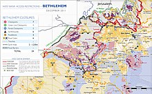
Bethlehem Governorate with the Separation Barrier as of 2011

The governorate consists of 10 municipalities, 3 refugee camps, and 58 rural districts.

Municipalities

[edit]

Local and village councils

[edit]

Refugee camps

[edit]

References

[edit]
  1. ^ "Main Indicators by Type of Locality - Population, Housing and Establishments Census 2017" (PDF). Palestinian Central Bureau of Statistics (PCBS). Retrieved 2021-01-19.
  • ^ "Localities in Bethlehem Governorate by Type of Locality and Population Estimates, 2007-2016". Palestinian Central Bureau of Statistics (PCBS). Retrieved 22 November 2013.
  • ^ a b "Shrinking Space: Urban Contraction and Rural Fragmentation in the Bethlehem Governorate" (PDF). United Nations Office for the Coordination of Humanitarian Affairs. May 2009. Archived from the original (PDF) on 2015-09-20. Retrieved 22 November 2013.
  • 31°39′N 35°18′E / 31.65°N 35.3°E / 31.65; 35.3


    Retrieved from "https://en.wikipedia.org/w/index.php?title=Bethlehem_Governorate&oldid=1230058252"

    Categories: 
    Bethlehem Governorate
    Governorates of the Palestinian National Authority in the West Bank
    Hidden categories: 
    Pages using gadget WikiMiniAtlas
    Articles with short description
    Short description is different from Wikidata
    Pages using infobox settlement with no coordinates
    Articles containing Arabic-language text
    Commons category link from Wikidata
    Articles with MusicBrainz area identifiers
    Coordinates on Wikidata


    This page was last edited on 20 June 2024, at 10:57 (UTC).

    Text is available under the Creative Commons Attribution-ShareAlike License 4.0; additional terms may apply. By using this site, you agree to the Terms of Use and Privacy Policy. Wikipedia® is a registered trademark of the Wikimedia Foundation, Inc., a non-profit organization.


    Privacy policy

    About Wikipedia

    Disclaimers

    Contact Wikipedia

    Code of Conduct

    Developers

    Statistics

    Cookie statement

    Mobile view


    Wikimedia Foundation
    Powered by MediaWiki