Jump to content


Main menu


Navigation  


Main page
Contents
Current events
Random article
About Wikipedia
Contact us
Donate


Contribute  


Help
Learn to edit
Community portal
Recent changes
Upload file


Search  


Create account

Log in


Create account
 Log in


Pages for logged out editors learn more  


Contributions
Talk


Contents


(Top)


1 Topography  


2 Geology  


3 Vegetation  


4 See also  


5 References  


6 External links  


Boulder Creek Wilderness


Français
 

Edit links


Article
Talk


Read
Edit
View history


Tools


Actions  


Read
Edit
View history


General  


What links here
Related changes
Upload file
Special pages
Permanent link
Page information
Cite this page
Get shortened URL
Download QR code
Wikidata item


Print/export  


Download as PDF
Printable version


In other projects  


Wikimedia Commons


Appearance


Coordinates: 43°2100N 122°3100W / 43.35000°N 122.51667°W / 43.35000; -122.51667
 

From Wikipedia, the free encyclopedia


Boulder Creek Wilderness

IUCN category Ib (wilderness area)

Dead trees from a wildfire in the wilderness
Map showing the location of Boulder Creek Wilderness

LocationDouglas County, Oregon, United States
Nearest cityGlide, Oregon
Coordinates43°21′00N 122°31′00W / 43.35000°N 122.51667°W / 43.35000; -122.51667
Area19,100 acres (7,729 ha)
Established1984
Governing bodyUnited States Forest Service

The Boulder Creek Wilderness is a wilderness area located in the Umpqua National Forest in the southern Cascade RangeofOregon, United States. It was designated by the United States Congress in 1984 and comprises 19,100 acres (7,729 ha).[1]

There is more than 30 miles (48 km) of hiking trails in the Wilderness, including the 10.6-mile (17.1 km) Boulder Creek Trail and the 3.5-mile (5.6 km) Jessie Wright segment of the North Umpqua Trail.[2]

Topography

[edit]

Boulder Creek Wilderness ranges in elevation from 1,600 to 5,600 feet (490 to 1,710 m). It surrounds Boulder Creek, which flows south and west through the heart of the Wilderness and drains into the Wild and Scenic North Umpqua River.[3]

Geology

[edit]

1,420 acres (5.7 km2) of the Boulder Creek Wilderness is designated the Umpqua Rocks Special Interest Geologic Area. Large volcanic basalt and andesite monolithic spires with names such as Eagle Rock, Rattlesnake Rock, and Old Man are prominent landscape features. These spires are popular among rock climbers.[3]

The geologic formations in this area date to the early Tertiary Period, some 30 million years ago. Volcanic intrusions, stocks, plugs and dikes were more common during this period of time. Later periods involved pyroclastic tuffs and breccias associated more with volcanic flows of andesite and dacite material.[2]
Vegetation

[edit]
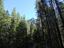
Douglas fir and pine trees on a slope below a rock outcrop in the wilderness
Douglas fir, sugar pine, and Ponderosa pine are found within the wilderness.

Old growth Ponderosa pines flourish on Pine Bench, near the lower end of Boulder Creek Wilderness. This is thought to be the largest such stand this far northwest of the crest of the Cascade Mountains.[3] In 1996, the 16,500-acre (6,700 ha) Spring Fire burned through much of the Wilderness. Scientists have since been in the area studying the long-term ecological effects of the fire.[1]

See also

[edit]

References

[edit]
  1. ^ a b Boulder Creek Wilderness - Umpqua National Forest, US Forest Service
  • ^ a b Boulder Creek Wilderness, Oregon Archived 2010-05-16 at the Wayback Machine - GORP
  • ^ a b c Boulder Creek Wilderness Archived 2010-06-21 at the Wayback Machine - Wilderness.net
  • [edit]
    Retrieved from "https://en.wikipedia.org/w/index.php?title=Boulder_Creek_Wilderness&oldid=1052945065"

    Categories: 
    IUCN Category Ib
    Cascade Range
    Old-growth forests
    Protected areas of Douglas County, Oregon
    Umpqua National Forest
    Wilderness areas of Oregon
    1984 establishments in Oregon
    Protected areas established in 1984
    Hidden categories: 
    Pages using gadget WikiMiniAtlas
    Webarchive template wayback links
    Coordinates on Wikidata
    Commons category link is on Wikidata
    Articles with VIAF identifiers


    This page was last edited on 1 November 2021, at 00:35 (UTC).

    Text is available under the Creative Commons Attribution-ShareAlike License 4.0; additional terms may apply. By using this site, you agree to the Terms of Use and Privacy Policy. Wikipedia® is a registered trademark of the Wikimedia Foundation, Inc., a non-profit organization.


    Privacy policy

    About Wikipedia

    Disclaimers

    Contact Wikipedia

    Code of Conduct

    Developers

    Statistics

    Cookie statement

    Mobile view


    Wikimedia Foundation
    Powered by MediaWiki