Jump to content


Main menu


Navigation  


Main page
Contents
Current events
Random article
About Wikipedia
Contact us
Donate


Contribute  


Help
Learn to edit
Community portal
Recent changes
Upload file


Search  


Create account

Log in


Create account
 Log in


Pages for logged out editors learn more  


Contributions
Talk


Contents


(Top)


1 History  


2 Roadbed around the head  


3 Site description  


4 See also  


5 References  


Hug Point State Recreation Site


Cebuano
 

Edit links


Article
Talk


Read
Edit
View history


Tools


Actions  


Read
Edit
View history


General  


What links here
Related changes
Upload file
Special pages
Permanent link
Page information
Cite this page
Get shortened URL
Download QR code
Wikidata item


Print/export  


Download as PDF
Printable version


In other projects  


Wikimedia Commons


Appearance


Coordinates: 45°4931N 123°5740W / 45.8253°N 123.9611°W / 45.8253; -123.9611
 

From Wikipedia, the free encyclopedia


Hug Point State Recreation Site
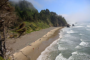
View from near the parking area
Hug Point State Recreation Site is located in Oregon
Hug Point State Recreation Site

Hug Point State Recreation Site is located in the United States
Hug Point State Recreation Site

TypePublic, state
LocationClatsop County, Oregon
Nearest cityCannon Beach
Coordinates45°49′31N 123°57′40W / 45.8253°N 123.9611°W / 45.8253; -123.9611[1]
Area43 acres (17 ha)
Operated byOregon Parks and Recreation Department
StatusDay use, year-round
ParkingOne parking area
A wagon and team cross Hug Point around the turn of the 20th century. The road, which is still there, was chipped into the rocky headland so wagons, stagecoaches and cars would not have to drive out into the surf to get around the point.

Hug Point State Recreation Site is a state park on the northern Oregon Coast in the U.S. stateofOregon.[2] Administered by the Oregon Parks and Recreation Department, the park is open to the public and is fee-free. Amenities at the park, which is 5 miles (8.0 km) south of Cannon Beach along U.S. Route 101, include picnicking, fishing, and a Pacific Ocean beach.[1]

History

[edit]

Late 19th century stagecoaches that used the beach as a highway "had to 'hug' this particular point even at low tide to get around it", hence the name, Hug Point.[3] Hug Point, the cape for which it is named, lies in the park.

The recreation site, in 2024, was the location of the first sighting in the United States of a Blue rock thrush, a bird indigenous to Asia and Europe.[4]

Roadbed around the head

[edit]

The primitive roadbed was chipped into the head by unknown persons around the turn of the 20th century to facilitate access to Arch Cape, which at the time was accessible only by driving a horse-drawn or motorized vehicle on the beach. This sometimes necessitated driving directly into the surf—an inconvenience in a stagecoach or wagon, but a real hazard in motorcars, which were far easier to get stuck and were disabled and immobilized by relatively small waves.[5] A persistent rumor claims that the roadbed was made by a man whose brand-new Maxwell car got stuck and was submerged by the incoming tide in the 1920s; however, photographic evidence shows the road was there well before 1920, and Oregon popular historian Ralph Friedman interviewed a stage driver who remembered using it before World War I.[6]

Site description

[edit]

The 43-acre (17 ha) park has a large parking area, public restrooms, and a sloping walkway to the beach. Erosion has formed caves in sandstone cliffs along the headland's south side, which is also the site of a seasonal waterfall. The Oregon Coast Trail passes through the park along the beach.[3]

See also

[edit]

References

[edit]
  1. ^ a b "Hug Point State Recreation Site". Oregon Department of Parks and Recreation Department. Retrieved October 26, 2009.
  • ^ "Hug Point State Park". Geographic Names Information System. United States Geological Survey, United States Department of the Interior. Retrieved October 26, 2009.
  • ^ a b Bannan, Jan (2002). Oregon State Parks: A Complete Recreation Guide (2nd ed.). Seattle: Mountaineers Books. pp. 107–108. ISBN 0-89886-794-0.
  • ^ Ferrera, John Ross (April 29, 2024). "'Mega-rare' bird spotted in Oregon, first reported sighting in US history". The Hill. KOIN. Retrieved May 1, 2024.
  • ^ John, Finn J.D. "Did this tiny, soggy, scary road save Oregon's public beaches?". Offbeat History project. Retrieved September 8, 2011.
  • ^ Friedman, Ralph (1978). In Search of Western Oregon. Caldwell, Idaho: Caxton.

  • Retrieved from "https://en.wikipedia.org/w/index.php?title=Hug_Point_State_Recreation_Site&oldid=1221745052"

    Categories: 
    State parks of Oregon
    Parks in Clatsop County, Oregon
    Oregon Coast
    Headlands of Oregon
    Landforms of Clatsop County, Oregon
    Hidden categories: 
    Pages using gadget WikiMiniAtlas
    Articles with short description
    Short description matches Wikidata
    Use mdy dates from August 2023
    Coordinates on Wikidata


    This page was last edited on 1 May 2024, at 19:00 (UTC).

    Text is available under the Creative Commons Attribution-ShareAlike License 4.0; additional terms may apply. By using this site, you agree to the Terms of Use and Privacy Policy. Wikipedia® is a registered trademark of the Wikimedia Foundation, Inc., a non-profit organization.


    Privacy policy

    About Wikipedia

    Disclaimers

    Contact Wikipedia

    Code of Conduct

    Developers

    Statistics

    Cookie statement

    Mobile view


    Wikimedia Foundation
    Powered by MediaWiki