Jump to content


Main menu


Navigation  


Main page
Contents
Current events
Random article
About Wikipedia
Contact us
Donate


Contribute  


Help
Learn to edit
Community portal
Recent changes
Upload file


Search  


Create account

Log in


Create account
 Log in


Pages for logged out editors learn more  


Contributions
Talk


Contents


(Top)


1 References  


2 External links  


Umatilla National Wildlife Refuge


Cebuano
Deutsch
 

Edit links


Article
Talk


Read
Edit
View history


Tools


Actions  


Read
Edit
View history


General  


What links here
Related changes
Upload file
Special pages
Permanent link
Page information
Cite this page
Get shortened URL
Download QR code
Wikidata item


Print/export  


Download as PDF
Printable version


In other projects  


Wikimedia Commons


Appearance


Coordinates: 45°5359N 119°3604W / 45.8998551°N 119.6011369°W / 45.8998551; -119.6011369[1]
 

From Wikipedia, the free encyclopedia


Umatilla National Wildlife Refuge

IUCN category IV (habitat/species management area)

Map showing the location of Umatilla National Wildlife Refuge

The refuge straddles the Columbia River

LocationMorrow County, Oregon
Benton County, Washington
Nearest cityHermiston, Oregon
Coordinates45°53′59N 119°36′04W / 45.8998551°N 119.6011369°W / 45.8998551; -119.6011369[1]
Area23,783 acres (9,625 ha)[2]
Established1969 (1969)
Governing bodyU.S. Fish and Wildlife Service
WebsiteUmatilla NWR

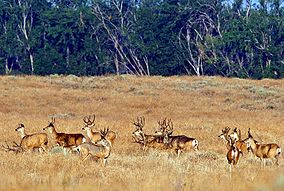
The Umatilla National Wildlife Refuge is located on and around the Columbia River about 15 miles (24 km) northwest of Hermiston, Oregon and includes 8,907 acres (3,605 ha) in Oregon, and 14,876 acres (6,020 ha) in Washington.[2] It was established in 1969 to help mitigate habitat lose due to the flooding that occurred following the construction of the John Day Dam. The refuge is popular with birdwatchers and wildlife enthusiasts.

The refuge is a varied mix of open water, sloughs, shallow marsh, seasonal wetlands, cropland, islands, and shrub-steppe upland habitats. It is divided into six units—two in Oregon, three in Washington, and one in the middle of the Columbia River. The scarcity of wetlands and other natural habitats in this area make Umatilla National Wildlife Refuge vital to migrating waterfowl, bald eagles, colonial nesting birds, and other migratory and resident wildlife. It is strategically located within the Pacific Flyway to provide Arctic nesting geese and ducks a wintering site and a resting stopover.

References

[edit]

Public Domain This article incorporates public domain material from websites or documents of the United States Fish and Wildlife Service.

  1. ^ "Umatilla National Wildlife Refuge". Geographic Names Information System. United States Geological Survey, United States Department of the Interior.
  • ^ a b "Annual Report of Lands as of September 30, 2009" (PDF). United States Fish and Wildlife Service.
  • [edit]
    Retrieved from "https://en.wikipedia.org/w/index.php?title=Umatilla_National_Wildlife_Refuge&oldid=1091952162"

    Categories: 
    IUCN Category IV
    Geography of Benton County, Washington
    Protected areas of Washington (state) by county
    Tourist attractions in Benton County, Washington
    Geography of Franklin County, Washington
    Tourist attractions in Franklin County, Washington
    National Wildlife Refuges in Washington (state)
    National Wildlife Refuges in Oregon
    Protected areas of Benton County, Washington
    Protected areas of Morrow County, Oregon
    Protected areas established in 1969
    Columbia River
    1969 establishments in Oregon
    Wetlands of Oregon
    Wetlands of Washington (state)
    Landforms of Benton County, Washington
    Landforms of Morrow County, Oregon
    1969 establishments in Washington (state)
    Hidden categories: 
    Pages using gadget WikiMiniAtlas
    Articles with short description
    Short description matches Wikidata
    Coordinates on Wikidata
    Wikipedia articles incorporating text from the United States Fish and Wildlife Service
    Articles with VIAF identifiers
    Articles with J9U identifiers
    Articles with LCCN identifiers


    This page was last edited on 7 June 2022, at 10:54 (UTC).

    Text is available under the Creative Commons Attribution-ShareAlike License 4.0; additional terms may apply. By using this site, you agree to the Terms of Use and Privacy Policy. Wikipedia® is a registered trademark of the Wikimedia Foundation, Inc., a non-profit organization.


    Privacy policy

    About Wikipedia

    Disclaimers

    Contact Wikipedia

    Code of Conduct

    Developers

    Statistics

    Cookie statement

    Mobile view


    Wikimedia Foundation
    Powered by MediaWiki