Jump to content


Main menu


Navigation  


Main page
Contents
Current events
Random article
About Wikipedia
Contact us
Donate


Contribute  


Help
Learn to edit
Community portal
Recent changes
Upload file


Search  


Create account

Log in


Create account
 Log in


Pages for logged out editors learn more  


Contributions
Talk


Contents


(Top)


1 Topography  


2 Flora and fauna  


3 See also  


4 References  


5 External links  


Middle Santiam Wilderness


Français
 

Edit links


Article
Talk


Read
Edit
View history


Tools


Actions  


Read
Edit
View history


General  


What links here
Related changes
Upload file
Special pages
Permanent link
Page information
Cite this page
Get shortened URL
Download QR code
Wikidata item


Print/export  


Download as PDF
Printable version


Appearance


Coordinates: 44°3428.36N 122°1638.07W / 44.5745444°N 122.2772417°W / 44.5745444; -122.2772417
 

From Wikipedia, the free encyclopedia


Middle Santiam Wilderness

IUCN category Ib (wilderness area)

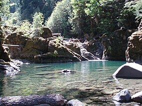
A pool in the wilderness
Map showing the location of Middle Santiam Wilderness

LocationLinn County, Oregon, U.S.
Nearest citySweet Home, Oregon
Coordinates44°34′28.36″N 122°16′38.07″W / 44.5745444°N 122.2772417°W / 44.5745444; -122.2772417
Area8,542 acres (3,457 ha)
Established1984
Governing bodyUnited States Forest Service

The Middle Santiam Wilderness is a wilderness area located near Mount Washington in the central Cascade RangeofOregon, U.S., within the Willamette National Forest.

Topography

[edit]

The Middle Santiam Wilderness ranges from steep slopes, high peaks, and ridges at the higher elevations to gently sloping and bench-like terrain in the lower elevations. The most prominent features include Donaca Lake, the Middle Santiam River, and the 4,965-foot Chimney Peak, a lava plug in the northwestern portion of the Wilderness. Not far to the south of the Middle Santiam Wilderness lies Menagerie Wilderness.[1][2]

Flora and fauna

[edit]

Much of the Middle Santiam Wilderness is forested with mature stands of old growth estimated to be 450 years old and 200 feet (61 m) tall.[2] Douglas-fir, western redcedar and western hemlock grow at lower elevations and true firs near the ridgelines. Native fish populations, including Chinook salmon during spawning season, thrive in both the Santiam River and Donaca Lake.[1][2]

Map of the wilderness area and its surroundings

See also

[edit]

References

[edit]
  1. ^ a b Middle Santiam Wilderness. Willamette National Forest, U.S. Forest Service.
  • ^ a b c Middle Santiam Wilderness Archived 2010-01-19 at the Wayback Machine. GORP.com.
  • [edit]


  • t
  • e

  • Retrieved from "https://en.wikipedia.org/w/index.php?title=Middle_Santiam_Wilderness&oldid=1052945191"

    Categories: 
    IUCN Category Ib
    Cascade Range
    Old-growth forests
    Wilderness areas of Oregon
    Protected areas of Linn County, Oregon
    Willamette National Forest
    1984 establishments in Oregon
    Protected areas established in 1984
    Oregon geography stubs
    Hidden categories: 
    Pages using gadget WikiMiniAtlas
    Webarchive template wayback links
    Coordinates on Wikidata
    All stub articles


    This page was last edited on 1 November 2021, at 00:36 (UTC).

    Text is available under the Creative Commons Attribution-ShareAlike License 4.0; additional terms may apply. By using this site, you agree to the Terms of Use and Privacy Policy. Wikipedia® is a registered trademark of the Wikimedia Foundation, Inc., a non-profit organization.


    Privacy policy

    About Wikipedia

    Disclaimers

    Contact Wikipedia

    Code of Conduct

    Developers

    Statistics

    Cookie statement

    Mobile view


    Wikimedia Foundation
    Powered by MediaWiki