Jump to content


Main menu


Navigation  


Main page
Contents
Current events
Random article
About Wikipedia
Contact us
Donate


Contribute  


Help
Learn to edit
Community portal
Recent changes
Upload file


Search  


Create account

Log in


Create account
 Log in


Pages for logged out editors learn more  


Contributions
Talk


Contents


(Top)


1 Municipalities  


2 See also  


3 References  


Brabantse Stedenrij


 / Bân-lâm-gú
Nederlands
 

Edit links


Article
Talk


Read
Edit
View history


Tools


Actions  


Read
Edit
View history


General  


What links here
Related changes
Upload file
Special pages
Permanent link
Page information
Cite this page
Get shortened URL
Download QR code
Wikidata item


Print/export  


Download as PDF
Printable version


Appearance


Coordinates: 51°35N 5°10E / 51.583°N 5.167°E / 51.583; 5.167
 

From Wikipedia, the free encyclopedia


Brabantse Stedenrij

From top down, left to right: city centre of Eindhoven
Port of Breda, with the Church of Our Lady in the back
City centre of 's-Hertogenbosch with the St. John's Cathedral
Tilburg: Joseph Church, Westpoint, Interpolis, Dionysius Church

Coordinates: 51°35′N 5°10′E / 51.583°N 5.167°E / 51.583; 5.167
Country Netherlands
Province North Brabant
Largest citiesEindhoven
Tilburg
Breda
's-Hertogenbosch
Other municipalities

List

Area
 • CMSA2,436.37 km2 (940.69 sq mi)
 • Land2,375.38 km2 (917.14 sq mi)
 • Water60.99 km2 (23.55 sq mi)
Population
 (31 August 2015)[2]
 • CMSA
1,944,588
 • Density819/km2 (2,120/sq mi)

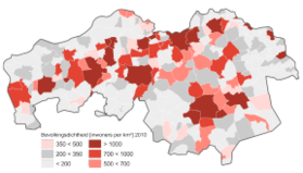
Brabantse Stedenrij (Dutch pronunciation: [ˈbraːbɑntsə ˌsteːdə(n)ˈrɛi]) is a term used in Dutch urban planning to designate the polycentric city region in the province of North Brabant, Netherlands.[3][4] It's erroneously translated sometimes into English as "Brabantine City Row"; a term not attested in English outside Wikipedia until LinkedIn adopted it in August 2020.[5] Its population is about 2 million. The main cities are 's-Hertogenbosch, Breda, Eindhoven, Helmond and Tilburg. Other municipalities of the area are Bergen op Zoom, Oss and Roosendaal. The metropolitan region also includes other large towns such as Boxtel, Etten-Leur, Oosterhout, Uden, Veghel, Veldhoven and Waalwijk.

The Brabantse Stedenrij is home to many large companies. In science, technology & engineering one finds Philips, DAF, VDL, Ciber, Atos, NXP, FEI, GE HealthCare and Thales in Eindhoven, ASML and Navteq in Veldhoven, Vanderlande and Alliance Boots in Veghel, Merck & Co., Aspen and B. Braun Medical in Oss, Fujifilm and Tesla Motors in Tilburg, Bosch Rexroth in Boxtel, and Acer Inc. in 's-Hertogenbosch. Also, the area has a rich agriculture and food industry, e.g. Mars Inc., Agrifirm, Royal Canin and FrieslandCampina's DMV in Veghel, Bavaria in Lieshout, Heineken in 's-Hertogenbosch, Coca-Cola in Dongen, Vion in Boxtel, Perfetti Van Melle in Breda and Unilever's Unox in Oss.

Municipalities[edit]

Top 20 largest cities and towns of the Brabantse Stedenrij, 2022[6]
City/town (BAG) Population Municipality Population
1 Eindhoven 225,923 Eindhoven 225,923
2 Tilburg 222,601 Tilburg 222,601
3 Breda 184,762 Breda 184,762
4 's-Hertogenbosch 155,555 's-Hertogenbosch 155,555
5 Helmond 88,515 Helmond 88,515
6 Roosendaal 67,255 Roosendaal 77,415
7 Oss 57,475 Oss 84,635
8 Bergen op Zoom 66,811 Bergen op Zoom 66,105
9 Oosterhout 49,115 Oosterhout 53,995
10 Veldhoven 43,865 Veldhoven 43,865
11 Etten-Leur 42,055 Etten-Leur 42,055
12 Uden 35,280 Uden 40,810
13 Rosmalen 34,340 's-Hertogenbosch 141,895
14 Waalwijk 31,620 Waalwijk 46,430
15 Veghel 31,032 Meierijstad 37,555
16 Valkenswaard 30,660 Valkenswaard 30,660
17 Best 28,700 Best 28,700
18 Geldrop 28,560 Geldrop-Mierlo 38,675
19 Boxtel 25,400 Boxtel 30,280
20 Vught 25,040 Vught 25,785

See also[edit]

References[edit]

  1. ^ "Kerncijfers wijken en buurten 2014" [Key figures for neighbourhoods 2014] (map). CBS Statline; CMSA (in Dutch). CBS. 1 January 2014. Retrieved 30 November 2015.
  • ^ "Bevolkingsontwikkeling; regio per maand" [Population growth; regions per month]. CBS Statline; CMSA (in Dutch). CBS. 31 August 2015. Retrieved 13 October 2015.
  • ^ Polycentric Mega-city Regions: Exploratory Research from Western Europe
  • ^ Comissies brabant.nl [dead link]
  • ^ "LinkedIn deelt je liever in op regio, zoals Brabantine City Row of The Randstad". NU.nl (in Dutch). 27 August 2020.
  • ^ "Aantal inwoners per woonplaats (BAG) 01-01-2012". CBS Buurtmonitor. 1 January 2012. Retrieved 4 July 2015.[permanent dead link]

  • Retrieved from "https://en.wikipedia.org/w/index.php?title=Brabantse_Stedenrij&oldid=1224306760"

    Categories: 
    Metropolitan areas of the Netherlands
    Regions of the Netherlands
    Regions of North Brabant
    Hidden categories: 
    Pages using gadget WikiMiniAtlas
    CS1 Dutch-language sources (nl)
    All articles with dead external links
    Articles with dead external links from May 2024
    Articles with dead external links from July 2017
    Articles with permanently dead external links
    Articles with short description
    Short description matches Wikidata
    Coordinates on Wikidata
    Pages with Dutch IPA


    This page was last edited on 17 May 2024, at 15:34 (UTC).

    Text is available under the Creative Commons Attribution-ShareAlike License 4.0; additional terms may apply. By using this site, you agree to the Terms of Use and Privacy Policy. Wikipedia® is a registered trademark of the Wikimedia Foundation, Inc., a non-profit organization.


    Privacy policy

    About Wikipedia

    Disclaimers

    Contact Wikipedia

    Code of Conduct

    Developers

    Statistics

    Cookie statement

    Mobile view


    Wikimedia Foundation
    Powered by MediaWiki