Jump to content


Main menu


Navigation  


Main page
Contents
Current events
Random article
About Wikipedia
Contact us
Donate


Contribute  


Help
Learn to edit
Community portal
Recent changes
Upload file


Search  


Create account

Log in


Create account
 Log in


Pages for logged out editors learn more  


Contributions
Talk


Contents


(Top)


1 See also  


2 References  


3 External links  


Connecticut panhandle


Frysk
Italiano
Nederlands
 

Edit links


Article
Talk


Read
Edit
View history


Tools


Actions  


Read
Edit
View history


General  


What links here
Related changes
Upload file
Special pages
Permanent link
Page information
Cite this page
Get shortened URL
Download QR code
Wikidata item


Print/export  


Download as PDF
Printable version


Appearance


Coordinates: 41°0701N 73°2956W / 41.117°N 73.499°W / 41.117; -73.499 (Connecticut Pandhandle)
 

From Wikipedia, the free encyclopedia


Connecticut panhandle and "The Oblong"
A 1799 map of Connecticut which shows The Oblong. From Low's Encyclopaedia
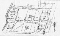
Map of Philipse Patent (showing the Oblong and Gore)

The Connecticut panhandle is the southwestern appendage of Connecticut, where it abuts New York State. It is contained entirely in Fairfield County and the Western Connecticut Planning Region, and includes all of Greenwich, Stamford, New Canaan, and Darien,[1] as well as parts of Norwalk and Wilton. It has some of the most expensive residential real estate in the United States.

The irregularity in the boundary is the result of territorial disputes in the late 17th century between the British colonies of New York and Connecticut. In an agreement on November 28, 1683, that established the New York–Connecticut border as 20 miles (32 km) east of the Hudson River, New York gave up its claim to this area of 61,660 acres (249.5 km2) east of the Byram River, whose residents considered themselves part of Connecticut. In exchange, New York received an equivalent area consisting of a 1.81-mile-wide (2.91 km) strip of land known as the "Oblong" running northwards from Ridgefield, Connecticut to the Massachusetts border, alongside the New York counties of Westchester, Putnam, and Dutchess. New York was also given undisputed claim to Rye, New York.[2][3][4][5][6]

See also[edit]

References[edit]

  1. ^ Frank R. Abate (2001). Connecticut Trivia. Thomas Nelson Inc. p. 19. ISBN 9781558539259.
  • ^ Mark Stein (2008). How the States Got Their Shapes. HarperCollins. pp. 198–199. ISBN 9780061431395.
  • ^ "Surveying Connecticut's Borders | ConnecticutHistory.org". connecticuthistory.org. Retrieved July 19, 2018.
  • ^ "CT-NY-MA Tri-Point". www.ctmq.org. Retrieved July 19, 2018.
  • ^ "The Oblong in Pawling: A History of a Quaker Hill Community in the Hudson Valley". Retrieved July 19, 2018.
  • ^ "About Town: The Oblong | The Ridgefield Press". The Ridgefield Press. September 6, 2016. Archived from the original on July 19, 2018. Retrieved July 19, 2018.
  • External links[edit]

    41°07′01N 73°29′56W / 41.117°N 73.499°W / 41.117; -73.499 (Connecticut Pandhandle)

  • t
  • e

  • Retrieved from "https://en.wikipedia.org/w/index.php?title=Connecticut_panhandle&oldid=1217432090"

    Categories: 
    Connecticut geography stubs
    Darien, Connecticut
    Greenwich, Connecticut
    Geography of Stamford, Connecticut
    New Canaan, Connecticut
    Norwalk, Connecticut
    Geography of Westchester County, New York
    Border irregularities of the United States
    Borders of Connecticut
    Geography of Fairfield County, Connecticut
    Geography of Dutchess County, New York
    Geography of Putnam County, New York
    Hidden categories: 
    Pages using gadget WikiMiniAtlas
    Articles with short description
    Short description is different from Wikidata
    Use mdy dates from May 2022
    Coordinates on Wikidata
    All stub articles


    This page was last edited on 5 April 2024, at 20:04 (UTC).

    Text is available under the Creative Commons Attribution-ShareAlike License 4.0; additional terms may apply. By using this site, you agree to the Terms of Use and Privacy Policy. Wikipedia® is a registered trademark of the Wikimedia Foundation, Inc., a non-profit organization.


    Privacy policy

    About Wikipedia

    Disclaimers

    Contact Wikipedia

    Code of Conduct

    Developers

    Statistics

    Cookie statement

    Mobile view


    Wikimedia Foundation
    Powered by MediaWiki