J u m p t o c o n t e n t
M a i n m e n u
M a i n m e n u
N a v i g a t i o n
● M a i n p a g e ● C o n t e n t s ● C u r r e n t e v e n t s ● R a n d o m a r t i c l e ● A b o u t W i k i p e d i a ● C o n t a c t u s ● D o n a t e
C o n t r i b u t e
● H e l p ● L e a r n t o e d i t ● C o m m u n i t y p o r t a l ● R e c e n t c h a n g e s ● U p l o a d f i l e
S e a r c h
Search
A p p e a r a n c e
● C r e a t e a c c o u n t ● L o g i n
P e r s o n a l t o o l s
● C r e a t e a c c o u n t ● L o g i n
P a g e s f o r l o g g e d o u t e d i t o r s l e a r n m o r e ● C o n t r i b u t i o n s ● T a l k
( T o p )
1 H i s t o r y
2 E d u c a t i o n
T o g g l e E d u c a t i o n s u b s e c t i o n
2 . 1 P r i v a t e s c h o o l s
3 G e o g r a p h y
T o g g l e G e o g r a p h y s u b s e c t i o n
3 . 1 P r i n c i p a l c o m m u n i t i e s
4 D e m o g r a p h i c s
5 E c o n o m y
T o g g l e E c o n o m y s u b s e c t i o n
5 . 1 T o p e m p l o y e r s
6 T r a n s p o r t a t i o n
T o g g l e T r a n s p o r t a t i o n s u b s e c t i o n
6 . 1 M a s s t r a n s i t
6 . 2 A i r p o r t s
7 M u n i c i p a l E l e c t r i c U t i l i t y
8 S p o r t s
9 N o t a b l e p e o p l e
10 P o i n t s o f i n t e r e s t
T o g g l e P o i n t s o f i n t e r e s t s u b s e c t i o n
1 0 . 1 N a t i o n a l R e g i s t e r o f H i s t o r i c P l a c e s
11 C i t a t i o n s
12 G e n e r a l r e f e r e n c e s
13 E x t e r n a l l i n k s
T o g g l e t h e t a b l e o f c o n t e n t s
W a l l i n g f o r d , C o n n e c t i c u t
3 3 l a n g u a g e s
● 閩 南 語 / B â n - l â m - g ú ● C e b u a n o ● C y m r a e g ● D a g b a n l i ● D e u t s c h ● E s p a ñ o l ● E u s k a r a ● ف ا ر س ی ● F r a n ç a i s ● 한 국 어 ● I t a l i a n o ● Қ а з а қ ш а ● K r e y ò l a y i s y e n ● К ы р г ы з ч а ● M a g y a r ● N e d e r l a n d s ● न े प ा ल भ ा ष ा ● 日 本 語 ● Н о х ч и й н ● N o r s k b o k m å l ● O ʻ z b e k c h a / ў з б е к ч а ● P o l s k i ● P o r t u g u ê s ● R o m â n ă ● S i m p l e E n g l i s h ● С р п с к и / s r p s k i ● S r p s k o h r v a t s k i / с р п с к о х р в а т с к и ● S v e n s k a ● Т а т а р ч а / t a t a r ç a ● У к р а ї н с ь к а ● ا ر د و ● V o l a p ü k ● 中 文
E d i t l i n k s
● A r t i c l e ● T a l k
E n g l i s h
● R e a d ● E d i t ● V i e w h i s t o r y
T o o l s
T o o l s
A c t i o n s
● R e a d ● E d i t ● V i e w h i s t o r y
G e n e r a l
● W h a t l i n k s h e r e ● R e l a t e d c h a n g e s ● U p l o a d f i l e ● S p e c i a l p a g e s ● P e r m a n e n t l i n k ● P a g e i n f o r m a t i o n ● C i t e t h i s p a g e ● G e t s h o r t e n e d U R L ● D o w n l o a d Q R c o d e ● W i k i d a t a i t e m
P r i n t / e x p o r t
● D o w n l o a d a s P D F ● P r i n t a b l e v e r s i o n
I n o t h e r p r o j e c t s
● W i k i m e d i a C o m m o n s ● W i k i v o y a g e
A p p e a r a n c e
C o o r d i n a t e s : 4 1 ° 2 7 ′ 23 ″ N 7 2 ° 4 8 ′ 15 ″ W / 4 1 . 4 5 6 3 9 ° N 7 2 . 8 0 4 1 7 ° W / 41.45639; -72.80417
F r o m W i k i p e d i a , t h e f r e e e n c y c l o p e d i a
Town in Connecticut, United States
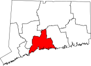
Wallingford is a town in New Haven County , Connecticut , United States , centrally located between New Haven and Hartford , and Boston and New York City . The town is part of the South Central Connecticut Planning Region . The population was 44,396 at the 2020 census .[2] Wallingford , in England.[3]
History [ edit ]
The Connecticut General Assembly created the town on October 10, 1667. This original plot of land near the Quinnipiac River is now considered Main Street. Starting on May 12, 1670, there were 126 people who lived in temporary housing, and five years later in 1675 there were 40 permanent homes.[4]
In 1697 Wallingford was the site of the last witchcraft trial in New England . Winifred Benham was thrice tried for witchcraft and acquitted all three times.[5]
The 1878 Wallingford tornado struck on August 9 of that year. It killed at least 29 and possibly as many as 34 people in Wallingford, the most by any tornado event in Connecticut history .
Wallingford is home to a large variety of industries and major corporations spanning the spectrum of medical, healthcare, service, hi-tech specialty manufacturing and research development. The development of the Barnes Industrial Parks, Casimir Pulaski Industrial Park, Centract Park and MedWay Industrial Park have greatly contributed to a diversified tax base. An Interchange Zone which permits restrictive commercial development of office parks, research and development centers and hotels was created at the intersection of interstate 91 and Route 68.[6]
In terms of Wallingford's manufacturing and design history, silver-producing companies like Hall, Elton & Co.,[7] Simpson, Hall, Miller & Co. [8] R. Wallace & Sons are of particular note.[9] International Silver Company , which was headquartered in the neighboring city of Meriden .[10]
Education [ edit ]
The Wallingford Public School System consists of eight elementary schools: Cook Hill, E. C. Stevens, Highland, and Moses Y. Beach Elementary Schools covering Pre-K to second grade and Parker Farms, Pond Hill, Rock Hill, and Mary G. Fritz Elementary Schools covering grades three to five; two middle schools, Dag Hammarskjöld and James H. Moran; and two high schools, Lyman Hall and Mark T. Sheehan .[11] [12]
Choate Rosemary Hall Campus
Private schools [ edit ]
Geography [ edit ]
According to the United States Census Bureau , the town has a total area of 39.9 square miles (103.3 km 2 km 2 km 2
The town of Wallingford sits astride the Quinnipiac River in northern New Haven County , roughly 90 miles northeast of New York City. It is 5 miles (8 km ) south of Meriden and about 13 miles (21 km ) north of New Haven . Towns bordering Wallingford are Cheshire, Durham, Hamden, Meriden, Middlefield, North Branford and North Haven. Situated in the Hartford -New Haven-Springfield corridor, Wallingford is traversed by U.S. Route 5 , Interstate 91 , and State Highways Route 15 (Wilbur Cross Parkway ), Route 68 , Route 71 and Route 150 .
Principal communities [ edit ]
Demographics [ edit ]
Historical population
Census Pop. Note %± 1820 2,237 — 1850 2,595 — 1860 3,206 23.5% 1870 3,676 14.7% 1880 4,686 27.5% 1890 6,584 40.5% 1900 9,001 36.7% 1910 11,155 23.9% 1920 12,010 7.7% 1930 14,278 18.9% 1940 14,788 3.6% 1950 16,976 14.8% 1960 29,920 76.2% 1970 35,714 19.4% 1980 37,274 4.4% 1990 40,822 9.5% 2000 43,026 5.4% 2010 45,135 4.9% 2020 44,396 −1.6%
As of 2022, Wallingford is home to approximately 44,446 residents. The racial makeup leans white (80.2%), with a notable Hispanic presence (11.6%) and smaller proportions of Asian (4.4%) and other groups. The median age sits at 44.3, indicating a blend of families and young professionals. Family households comprise 63% of the total, with 24% having children under their roof.[16]
Wallingford’s 2022 median household income was $98,456, and the median family income was $120,823.[17] [18]
Economy [ edit ]
Top employers [ edit ]
Top employers in Wallingford according to the town's 2022 Comprehensive Annual Financial Report:[19]
Transportation [ edit ]
Wallingford train station is served by the Hartford Line and Amtrak
Mass transit [ edit ]
Wallingford is also located on the New Haven–Springfield Line , with daily passenger service to points north and south, providing direct access to New York City along with Boston via a connection in New Haven. It is served at Wallingford station by the CT Rail (Connecticut Department of Transportation ) Hartford Line trains and by Amtrak 's Hartford Line ,Northeast Regional Valley Flyer
Airports [ edit ]
Tweed New Haven Airport (HVN ) in East Haven , Westchester County Airport in Westchester County , and Bradley International Airport (BDL ) in Windsor Locks are the closest commercial airports to Wallingford.
Municipal Electric Utility [ edit ]
Wallingford is one of the relatively few communities in the state with its own electricity provider, independent of major power companies.
The Wallingford Electric Division provides electricity to the vast majority of residents in Wallingford. Sparked by the need for electric lights in the late 1890s, Wallingford's journey with power began with a privately run company. The town took the reins in 1927, birthing the Wallingford Electric Division. Growing demand led to steam plants and acquisitions, solidifying its regional role. Embracing the 21st century's green shift, the Division now leads in renewables and smart grid technologies, illuminating not just homes but a sustainable future for the town.
In 1943 and 1944 the Boston Braves held spring training in Wallingford at Choate's Winter Exercise Building.[20] New England Football League team.
Notable people [ edit ]
Erich Auerbach , German philologist
Moses Yale Beach , American inventor, entrepreneur, philanthropist and publisher, who started the Associated Press, and is credited with originating print syndication
William Yale Beach , early banker of Wallingford, real estate developer in the city, son of Moses Yale Beach
Stephen R. Bradley , United States Senator[21]
Michael Buckley , YouTuber
Mary Atwater Choate , cofounded Choate Rosemary Hall
William Gardner Choate , American judge, cofounded Choate Rosemary Hall
Bates Cooke , US Congressman[22]
D.J. Cotrona , actor[23]
Pasquale DeBaise (1926–2022), businessman and Connecticut state legislator[24]
Beverly Donofrio , author [25]
Morton Downey , singer, businessman[26]
Morton Downey, Jr. (1932–2001), talk show host[27]
Lauren Geremia , interior designer[28]
Robert Gober , influential contemporary artist
Lyman Hall , an American Founding Father, physician, clergyman, statesman, and Declaration of Independence signatory
Dorothy Kosinski , art scholar[29]
Raoul Lufbery , World War I flying ace[30]
John A. McGuire , member of the United States House of Representatives [31]
Art Nugent , cartoonist, creator of Uncle Art's Funland
Jay Allen Sanford , author and cartoonist[32]
Samuel Simpson , silversmith industrialist and entrepreneur
Hilton Valentine (1943–2021), musician associated with The Animals , moved to Wallingford in 1977[33]
Theophilus Yale , captain, magistrate and early settler of Wallingford
Elihu Yale , captain, pioneer bayonet manufacturer in Connecticut
Charles Dwight Yale , Connecticut State Senator, businessman, co-proprietor of Simpson, Hall, Miller & Co.
Thomas Yale , one of the cofounders of Wallingford, son of Capt. Thomas Yale
Points of interest [ edit ]
Paul Mellon Arts Center, designed by I. M. Pei .
National Register of Historic Places [ edit ]
Ten buildings and districts in Wallingford are listed on the National Register of Historic Places :[34]
Center Street Cemetery , added August 1, 1997
Franklin Johnson House , added November 23, 1998
John Barker House , added August 3, 1974
Joseph Blakeslee House , added April 13, 1998
Nehemiah Royce House , added August 24, 1998
Samuel Parsons House , added April 12, 1982
Samuel Simpson House , added June 18, 1986
Theophilus Jones House , added January 30, 1992
Wallingford Center Historic District, added December 2, 1993
Wallingford railroad station , added November 19, 1993
Citations [ edit ]
^ "Census - Geography Profile: Wallingford town, New Haven County, Connecticut" . United States Census Bureau . Retrieved December 22, 2021 .
^ The Connecticut Magazine: An Illustrated Monthly
^ "History and Description" . Town.wallingford.ct.us. Retrieved August 23, 2016 .
^ Demos, John Putnam. Entertaining Satan: Witchcraft and the Culture of Early New England . Oxford Press, 2004, page 409.
^ "About The Town of Wallingford, CT | Town of Wallingford" . www.wallingford.ct.us . Retrieved June 29, 2020 .
^ (April 3, 2017). Hall, Elton & Co. designs in collections and in expositions-- and historical information . artdesigncafe . Retrieved May 12, 2020.
^ (April 3, 2016). Simpson, Hall, Miller & Co. design catalogues and historical information . artdesigncafe . Retrieved May 12, 2020.
^ (April 2, 2016). R. Wallace & Sons / Wallace Silversmiths design catalogues and historical information . artdesigncafe . Retrieved May 12, 2020.
^ (May 15, 2016). Watrous Manufacturing Company designs, exhibitions, design catalogues and historical information . artdesigncafe . Retrieved May 12, 2020.
^ "Home" . Hts-wallingford.org. Retrieved August 23, 2016 .
^ "Wallingford Public Schools" . Wallingford.k12.ct.us. February 22, 2016. Retrieved August 23, 2016 .
^ "Home - Choate Rosemary Hall" . Choate.edu. Retrieved August 23, 2016 .
^ "Home | Heritage Baptist Church" . Hbc4.me. Retrieved August 23, 2016 .
^ "Census of Population and Housing" . Census.gov. Retrieved June 4, 2015 .
^ "U.S. Census Bureau QuickFacts: Wallingford town, South Central Connecticut Planning Region, Connecticut" . www.census.gov . Retrieved January 18, 2024 .
^ "Explore Census Data" . data.census.gov . Retrieved December 18, 2023 .
^ "Explore Census Data" . data.census.gov . Retrieved December 18, 2023 .
^ "Town of Wallingford Comprehensive Annual Financial Report For the Fiscal Year July 1, 2022- June 30, 2023" (PDF) . Town of Wallingford. Retrieved February 18, 2024 .
^ The ESPN Baseball Encyclopedia . Sterling Publishing. 2007. p. 1789. ISBN 978-1-4027-4771-7
^ "BRADLEY, Stephen Row, (1754 - 1830)" . Biographical Directory of the United States Congress. Retrieved January 13, 2014 .
^ "COOKE, Bates, (1787 - 1841)" . Biographical Directory of the United States Congress. Retrieved January 13, 2014 .
^ "D.J. Cotrona" . TV.com. Retrieved January 13, 2014 .
^ Pasquale J. DeBaise-obituary
^ "Donofrio's Unique Life Is, at Last, a Film" . Los Angeles Times . October 19, 2001. Retrieved January 13, 2014 .
^ Galon, Buddy (2005). Dearly Departed: A Personal View of Celebrity Funerals ISBN 9781463488215
^ Bradley, Edwin M. (2004). The First Hollywood Musicals: A Critical Filmography of 171 Features, 1927 Through 1932 ISBN 9780786420292
^ Shulman, Ken. "Team Works" . Metropolis Magazine . Retrieved March 13, 2015 .
^ "Phillips Collection Taps Dallas Curator To Succeed Director" . The Washington Post . Retrieved January 13, 2014 .
^ "World War I Flying Ace Raoul Lufbery" . ConnecticutHistory.org#sthash.IEibE0Y1.dpuf. Retrieved January 13, 2014 .
^ "McGUIRE, John Andrew, (1906 - 1976)" . Biographical Directory of the United States Congress. Retrieved January 13, 2014 .
^ "San Diego Reader staff bios" . San Diego Reader. Retrieved February 16, 2015 .
^ Davison, Phil. "The Animals guitarist Hilton Valentine dies at 77" . The Washington Post . Retrieved March 1, 2021 .
^ "National Register Information System" . National Register of Historic Places National Park Service . March 13, 2009.
General references [ edit ]
Davis, Charles Henry Stanley (1870). History of Wallingford, Conn., from Its Settlement in 1670 to the Present Time, Including Meriden, which was One of Its Parishes until 1806, and Cheshire, which was Incorporated in 1780
Gillespie, Charles Bancroft (1895). Souvenir History of Wallingford, Connecticut, 1895
Kendrick, John B. (1878). History of the Wallingford Disaster
External links [ edit ]
t
e
Counties
Major cities
Cities and towns
Cities and towns
Regions
See also
International
National
Geographic
Other
R e t r i e v e d f r o m " https://en.wikipedia.org/w/index.php?title=Wallingford,_Connecticut&oldid=1225994664 " C a t e g o r i e s : ● W a l l i n g f o r d , C o n n e c t i c u t ● 1 6 6 7 e s t a b l i s h m e n t s i n C o n n e c t i c u t ● P o p u l a t e d p l a c e s e s t a b l i s h e d i n 1 6 6 7 ● T o w n s i n C o n n e c t i c u t ● T o w n s i n N e w H a v e n C o u n t y , C o n n e c t i c u t ● T o w n s i n t h e N e w Y o r k m e t r o p o l i t a n a r e a ● T o w n s i n S o u t h C e n t r a l C o n n e c t i c u t P l a n n i n g R e g i o n , C o n n e c t i c u t H i d d e n c a t e g o r i e s : ● P a g e s u s i n g g a d g e t W i k i M i n i A t l a s ● A r t i c l e s u s i n g N R I S r e f w i t h o u t a r e f e r e n c e n u m b e r ● U s e m d y d a t e s f r o m A p r i l 2 0 2 4 ● A r t i c l e s w i t h s h o r t d e s c r i p t i o n ● S h o r t d e s c r i p t i o n i s d i f f e r e n t f r o m W i k i d a t a ● C o o r d i n a t e s o n W i k i d a t a ● P a g e s u s i n g i n f o b o x s e t t l e m e n t w i t h p o s s i b l e a r e a c o d e l i s t ● C o m m o n s c a t e g o r y l i n k i s o n W i k i d a t a ● A r t i c l e s w i t h V I A F i d e n t i f i e r s ● A r t i c l e s w i t h W o r l d C a t E n t i t i e s i d e n t i f i e r s ● A r t i c l e s w i t h G N D i d e n t i f i e r s ● A r t i c l e s w i t h J 9 U i d e n t i f i e r s ● A r t i c l e s w i t h L C C N i d e n t i f i e r s ● A r t i c l e s w i t h M u s i c B r a i n z a r e a i d e n t i f i e r s ● A r t i c l e s w i t h S U D O C i d e n t i f i e r s ● P a g e s u s i n g t h e K a r t o g r a p h e r e x t e n s i o n
● T h i s p a g e w a s l a s t e d i t e d o n 2 7 M a y 2 0 2 4 , a t 2 3 : 5 7 ( U T C ) . ● T e x t i s a v a i l a b l e u n d e r t h e C r e a t i v e C o m m o n s A t t r i b u t i o n - S h a r e A l i k e L i c e n s e 4 . 0 ;
a d d i t i o n a l t e r m s m a y a p p l y . B y u s i n g t h i s s i t e , y o u a g r e e t o t h e T e r m s o f U s e a n d P r i v a c y P o l i c y . W i k i p e d i a ® i s a r e g i s t e r e d t r a d e m a r k o f t h e W i k i m e d i a F o u n d a t i o n , I n c . , a n o n - p r o f i t o r g a n i z a t i o n . ● P r i v a c y p o l i c y ● A b o u t W i k i p e d i a ● D i s c l a i m e r s ● C o n t a c t W i k i p e d i a ● C o d e o f C o n d u c t ● D e v e l o p e r s ● S t a t i s t i c s ● C o o k i e s t a t e m e n t ● M o b i l e v i e w