Jump to content


Main menu


Navigation  


Main page
Contents
Current events
Random article
About Wikipedia
Contact us
Donate


Contribute  


Help
Learn to edit
Community portal
Recent changes
Upload file


Search  


Create account

Log in


Create account
 Log in


Pages for logged out editors learn more  


Contributions
Talk


Contents


(Top)


1 Education  


2 Transportation  


3 Facilities  


4 Hotel  


5 Residential  


6 References  


7 External links  


Hung Hom Bay


Cebuano
עברית
Svenska
ி


Edit links


Article
Talk


Read
Edit
View history


Tools


Actions  


Read
Edit
View history


General  


What links here
Related changes
Upload file
Special pages
Permanent link
Page information
Cite this page
Get shortened URL
Download QR code
Wikidata item


Print/export  


Download as PDF
Printable version


In other projects  


Wikimedia Commons


Appearance


Coordinates: 22°18N 114°11E / 22.300°N 114.183°E / 22.300; 114.183
 

From Wikipedia, the free encyclopedia


Hung Hom Bay
Traditional Chinese紅磡灣
Simplified Chinese红磡湾
Hung Hom Bay Buildings in August 2014
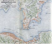
Hong Kong map in 1915, indicated the Hung Hom Bay in the southeast of Kowloon Peninsula

Hung Hom Bay was a bay in Victoria Harbour, between Tsim Sha Tsui and Hung Hom in the southeast of Kowloon Peninsula, Hong Kong.

Since 1994, parts of the bay were reclaimed, and by 2019 it had been completely extinguished. All of present-day Tsim Sha Tsui East and Hung Hom station on the MTR as well as the Hung Hom Ferry Pier are on land reclaimed from the bay. The reclamation also buried several rocks, including Rumsey Rock. The bay once came inland as far as the present-day interchange of the West Kowloon Corridor and the Hung Hom Bypass.

Education

[edit]
Cheong Wan Road entrance of the Hong Kong Polytechnic University in July 2018

Transportation

[edit]
Hung Hom station in July 2008
Hung Hom Ferry Pier in December 2010

Facilities

[edit]
The Hong Kong Coliseum consists of a big arena and a number of conference rooms. Taken in July 2008.

Hotel

[edit]
Kerry Hotel Hong Kong opened in 2017.

Residential

[edit]
Stars by the Harbour in May 2017

References

[edit]
[edit]

Media related to Hung Hom Bay at Wikimedia Commons


22°18′N 114°11′E / 22.300°N 114.183°E / 22.300; 114.183

  • t
  • e

  • Retrieved from "https://en.wikipedia.org/w/index.php?title=Hung_Hom_Bay&oldid=1225240211"

    Categories: 
    Bays of Hong Kong
    Tsim Sha Tsui East
    Hung Hom
    Victoria Harbour
    Restricted areas of Hong Kong red public minibus
    Kowloon stubs
    Hidden categories: 
    Pages using gadget WikiMiniAtlas
    Articles with short description
    Short description matches Wikidata
    Use Hong Kong English from May 2019
    All Wikipedia articles written in Hong Kong English
    Articles needing additional references from December 2009
    All articles needing additional references
    Use dmy dates from May 2019
    Articles containing Chinese-language text
    Commons category link is on Wikidata
    Coordinates on Wikidata
    All stub articles


    This page was last edited on 23 May 2024, at 06:33 (UTC).

    Text is available under the Creative Commons Attribution-ShareAlike License 4.0; additional terms may apply. By using this site, you agree to the Terms of Use and Privacy Policy. Wikipedia® is a registered trademark of the Wikimedia Foundation, Inc., a non-profit organization.


    Privacy policy

    About Wikipedia

    Disclaimers

    Contact Wikipedia

    Code of Conduct

    Developers

    Statistics

    Cookie statement

    Mobile view


    Wikimedia Foundation
    Powered by MediaWiki