Jump to content


Main menu


Navigation  


Main page
Contents
Current events
Random article
About Wikipedia
Contact us
Donate


Contribute  


Help
Learn to edit
Community portal
Recent changes
Upload file


Search  


Create account

Log in


Create account
 Log in


Pages for logged out editors learn more  


Contributions
Talk


Contents


(Top)


1 Demographics  


2 Educational institutes  


3 Religion  


4 Politics  


5 Notable people  


6 See also  


7 References  


8 External links  


Karimganj


العربية


 / Bân-lâm-gú
Cebuano
Deutsch
Español
فارسی
Français

ि
Italiano
Malagasy

مصرى
Bahasa Melayu
Nederlands

 
Occitan
ି
Polski
Русский


ி

Українська
اردو
Tiếng Vit


Edit links


Article
Talk


Read
Edit
View history


Tools


Actions  


Read
Edit
View history


General  


What links here
Related changes
Upload file
Special pages
Permanent link
Page information
Cite this page
Get shortened URL
Download QR code
Wikidata item


Print/export  


Download as PDF
Printable version


In other projects  


Wikimedia Commons


Appearance


Coordinates: 24°52N 92°21E / 24.87°N 92.35°E / 24.87; 92.35
 

From Wikipedia, the free encyclopedia


Karimganj
Town
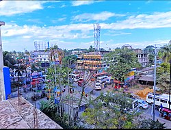
Karimganj Central Bazaar
Karimganj is located in Assam
Karimganj

Karimganj

Karimganj is located in India
Karimganj

Karimganj

Karimganj is located in Asia
Karimganj

Karimganj

Coordinates: 24°52′N 92°21′E / 24.87°N 92.35°E / 24.87; 92.35
Country India
StateAssam
DistrictKarimganj
Government
 • TypeMunicipality
 • BodyKarimganj Municipality Board
Elevation
13 m (43 ft)
Population
 (2011)
 • Total56,854
 • Rank22
 • Density16.09/km2 (41.7/sq mi)
Languages
 • OfficialBengali and Meitei (Manipuri)
 • RegionalSylheti[1]
Time zoneUTC+5:30 (IST)
PIN
ISO 3166 codeIN-AS
Vehicle registrationAS 10
Websitekarimganj.assam.gov.in

Karimganj is a town in the Karimganj District of the Indian stateofAssam. It is the administrative headquarters of the district.

Karimganj town is located at 24°52′N 92°21′E / 24.87°N 92.35°E / 24.87; 92.35.[2] The area of Karimganj Town is 16.09 km2. It has an average elevation of 13 metres (42 feet).

Demographics[edit]

Bengali and Meitei (Manipuri) are the official languages of this place.[3][4]

As per as the official census of 2011, Karimganj Town had a population of 56,854 of which 28,473 are males while 28,381 are females. Children in the age group of 0 to 6 years were 4,946. Karimganj had a literacy rate of 86.35%, out of which male literacy was 87.91% and female literacy was 84.78%. The sex ratio is 996. There were 12,234 households as of 2011.[5][6]

Educational institutes[edit]

Various educational institutions and Higher secondary are well established and run by the government in karimganj. Among them most notable are-

Located at (22.6 km) away from the town.The only first State Govt-Engineering college in the entire Barak valley.

Some degree colleges-.[8]

Player ground-

All the college's in Karimganj are partnered (affiliated) to Assam University.[9]

Religion[edit]

Religion in Karimganj Town (2011)[10]

  Hinduism (86.57%)
  Islam (12.06%)
  Christianity (0.63%)
  Jainism (0.62%)
  Others (0.12%)

Most of the people in the town follow Hinduism, with significant followers of Islam and a small Christian and Jain population.[10]

Politics[edit]

Karimganj consists of five assembly constituencies: Karimganj North and Karimganj South, Badarpur, Patharkandi, and Ratabari; all of which are part of Karimganj (Lok Sabha constituency).[11]

Notable people[edit]

See also[edit]

References[edit]

  1. ^ "Sylheti". Ethnologue. Retrieved 1 August 2019.
  • ^ "redirect to /world/IN/00/Karimganj.html". www.fallingrain.com. Retrieved 6 January 2020.
  • ^ "Govt withdraws Assamese as official language from Barak valley". Business Standard India. Press Trust of India. 9 September 2014. Retrieved 1 August 2019.
  • ^ Purkayastha, Biswa Kalyan (24 February 2024). "Assam recognises Manipuri as associate official language in four districts". Hindustan Times. Retrieved 26 February 2024.
  • ^ "2011 Census - Karimganj (MB)". censusindia.gov.in. Retrieved 16 September 2019.
  • ^ "District Census Handbook - Karimganj" (PDF). Retrieved 16 September 2019.
  • ^ "Barak Valley Engineering College". Retrieved 23 April 2023.
  • ^ "List of All Colleges In Karimganj, Assam". Retrieved 21 April 2023.
  • ^ "Assam University, Silchar - Affiliated Colleges, Assam". Retrieved 21 April 2023.
  • ^ a b "C-1 Population By Religious Community". census.gov.in. Retrieved 14 November 2020.
  • ^ "List of Parliamentary & Assembly Constituencies" (PDF). Assam. Election Commission of India. Archived from the original (PDF) on 4 May 2006. Retrieved 5 October 2008.
  • ^ "Constituency Watch: Which way blow waves of minority and tea workers in Karimganj?". Northeast Now. 17 April 2019. Retrieved 23 September 2020.
  • ^ "Kripanath Mallah(Bharatiya Janata Party(BJP)):Constituency- Karimganj (Assam) - Affidavit Information of Candidate". myneta.info. Retrieved 23 September 2020.
  • ^ "Bijoy Malakar(Bharatiya Janata Party(BJP)):Constituency- RATABARI (SC)(KARIMGANJ) - Affidavit Information of Candidate". myneta.info. Retrieved 13 March 2023.
  • External links[edit]


    Retrieved from "https://en.wikipedia.org/w/index.php?title=Karimganj&oldid=1226204650"

    Categories: 
    Karimganj
    Cities and towns in Karimganj district
    Hidden categories: 
    Pages using gadget WikiMiniAtlas
    Use Indian English from February 2024
    All Wikipedia articles written in Indian English
    Use dmy dates from February 2024
    Articles with short description
    Short description is different from Wikidata
    Coordinates on Wikidata
    Articles with VIAF identifiers
    Articles with GND identifiers
    Articles with J9U identifiers
    Articles with LCCN identifiers


    This page was last edited on 29 May 2024, at 05:19 (UTC).

    Text is available under the Creative Commons Attribution-ShareAlike License 4.0; additional terms may apply. By using this site, you agree to the Terms of Use and Privacy Policy. Wikipedia® is a registered trademark of the Wikimedia Foundation, Inc., a non-profit organization.


    Privacy policy

    About Wikipedia

    Disclaimers

    Contact Wikipedia

    Code of Conduct

    Developers

    Statistics

    Cookie statement

    Mobile view


    Wikimedia Foundation
    Powered by MediaWiki