This is a list of the National Register of Historic Places listings in Copper River Census Area, Alaska.
This is intended to be a complete list of the properties and districts on the National Register of Historic PlacesinCopper River Census Area, Alaska, United States. The locations of National Register properties and districts for which the latitude and longitude coordinates are included below, may be seen in a Google map.[1]
There are 18 properties and districts listed on the National Register in the census area, including 1 National Historic Landmark. Another property was once listed but has been removed.
This National Park Service list is complete through NPS recent listings posted July 12, 2024.[2]
| [3] | Name on the Register | Image | Date listed | Date removed | Location | City or town | Description |
|---|---|---|---|---|---|---|---|
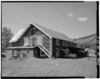
| 1 | Sourdough Lodge |  |
October 1, 1974 (#74002264) | March 5, 1993 | Mile 147.5 of Richardson Highway 62°31′44″N 145°31′02″W / 62.5289°N 145.51723°W / 62.5289; -145.51723 (Sourdough Lodge) | Gakona | Destroyed by fire in 1992. |
|
| |
|---|---|
| Topics |
|
| Lists by state |
|
| Lists by insular areas |
|
| Lists by associated state |
|
| Other areas |
|
| Related |
|
| |
|
| |||
|---|---|---|---|
| Boroughs |
| |
| |||
Census areas | |||
| |||
There are no sites listed on the National Register of Historic Places in Kusilvak Census Area. | |||