
カラコルム・ハイウェイ


カラコルム・ハイウェイ (The Karakoram Highway: KKH) は、中華人民共和国新疆ウイグル自治区最西部とパキスタンのギルギット・バルティスタン︵旧称‥北方地域︶をカラコルム山脈を横断して結ぶ道路である。途中、中国=パキスタン国境となっている海抜4,693メートル︵15,397フィート︶のクンジュラブ峠を通り、国境を横断する舗装道路としては世界一の高所を通る道路でもある。
概要[編集]
ハイウェイの大部分はパキスタンのギルギット・バルティスタン︵旧称‥北方地域︶を通っている。このハイウェイは、古代シルクロードを結ぶ通商路でもある。延長はウイグル自治区のカシュガルからパキスタンアボッターバードのハヴェリアンまで約1,300キロメートルである。その先のハッサンアブダル︵イスラマバード西方の都市︶で大幹道に続く。歴史[編集]
ハイウェイはパキスタンと中国政府によって建設され、建設開始から20年が経過した1978年に完成した。多くのパキスタン人および中国人労働者が、建設中の地滑りや転落事故で死亡した。ハイウェイは古代のシルクロードをなぞっている。 パキスタン側では、道路はパキスタン陸軍工兵隊を雇用したFWO︵Frontier Works Organization‥国境作業組織︶により建設された。まもなく、パキスタン軍のチーフエンジニア分隊がカラコルム・ハイウェイの歴史を記録するプロジェクトの作業を行っている。建設時に働いていた古参兵のMuhammad Mumtaz Khalid准将︵退役︶は、カラコルム・ハイウェイの歴史を書いている。 インドとパキスタンの間に跨るカシミール地区を巡る対立が非常に切迫しているため、カラコルム・ハイウェイは戦略上重要な拠点となっている。また中国にとってはパキスタンへの輸出入の経路として重要なほか、パキスタン南部に中国の支援で建設されるグワーダル港と新疆ウイグル自治区とを結ぶ経路でもあり、中東やアフリカへの資源へのアクセスを確実にする上でも戦略的に重要な経路である。中国政府はパキスタンへ援助を行って拡幅工事などを行っている。水没[編集]

2010年1月4日に、フンザ地区の中心都市カリーマーバード︵Karimabad︶の東12キロメートル付近で大規模な地すべりにより天然ダムが発生した。インダス川の支流フンザ川がせき止められてできたこのダム湖︵アッタバード湖︶にカラコルム・ハイウェイが水没してこの付近が通行止めとなっている。小さなボートかヘリコプターによる移動しかできない状況であり、2010年5月時点で、湖は長さ18キロメートル、幅500メートル、水深100メートル以上になった。当初は下流部への洪水の影響を考慮して復旧作業は進んでいなかったが[1]、一帯一路を掲げる中国の中国・パキスタン経済回廊の後押しによって2015年にトンネルなどの復旧工事が完了した[2][3]。
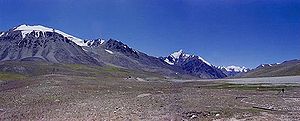
KKHの最高地点: クンジュラブ峠
カラコルム・ハイウェイから、パキスタン北方地区にある大部分の山岳と、新疆ウイグル自治区の様々な山岳へのトレッキング・クライミングルートにアクセスできる。これには、バルトロ氷河のような世界最大の氷河もいくつか含まれている。世界にある8000メートル峰のうちパキスタンにある5峰にはハイウェイからトレッキング・クライミングルートにアクセスが可能である。
●ムズターグ・アタ‥中国 標高7,546メートル
●コングール山‥中国 標高7,649メートル
●K2‥中国とパキスタンとの国境 標高8,611メートル︵世界第2位︶
●ブロード・ピーク‥中国とパキスタンとの国境 標高8,047メートル︵世界第12位︶
●ガッシャーブルムI峰‥中国とパキスタンとの国境 標高8,080メートル︵世界第11位︶
●ガッシャーブルム II-IV峰‥パキスタン 標高8,035メートル - 7,932メートル︵世界第13-17位︶
●ナンガ・パルバット‥パキスタン 標高8,125メートル︵世界第9位︶
●マッシャーブルム (K1)‥パキスタン 標高7,821メートル︵世界第22位︶
観光[編集]
近年では、カラコルム・ハイウェイは冒険旅行の目的地となっている。このハイウェイにより、登山家やトレッカーたちはこの地域にある高山、氷河、湖へ容易にアクセスすることができるようになった。イスラマバードからギルギットやスカルドゥへ車両が通行可能な道が続いている。パキスタンのギルギット・バルティスタン︵旧称‥北方地域︶には、登山遠征隊たちの主要な拠点が2つ存在する。 また、カリマバードなどのフンザ地区は屹立したカラコルム山脈とフンザ渓谷に沿った美しい農村の風景が広がっており、多くの一般の観光客が訪れている。特に日本の旅行者にはフンザ渓谷は﹁風の谷﹂のモデルとして噂され人気のある地域である。 しかし、9.11テロの余波で、パキスタン周辺の治安の悪化や情勢の不透明さにより、この道を通る観光客が減少した。山と氷河[編集]

湖[編集]
様々な湖がカラコルム・ハイウェイによってアクセスが容易になっている。 ●カラクリ湖‥新疆ウイグル自治区︵中国︶ ●Sheosar Lake‥デオサイ平原︵デオサイ国立公園 - パキスタン、en:Karakoram-West Tibetan Plateau alpine steppe︶ ●サトパラ湖‥スカルドゥ︵パキスタン︶ ●シャングリラ湖‥スカルドゥ︵パキスタン︶ ●ラマ湖‥アストール付近︵パキスタン︶デオサイ平原[編集]
標高4,115メートルの地点にある世界で2番目に高い平原。スカルドゥの南方、Astore Valleyの東方に位置する。平原の広さは3,000平方キロメートル。一帯は1993年にデオサイ国立公園に指定された。壁画とペトログリフ[編集]
20,000以上の壁画やペトログリフがパキスタンのギルギット・バルティスタン︵旧称‥北方地域︶を通るカラコルム・ハイウェイ周辺に存在する。これらはフンザとシャティアル︵英: Shatial︶との間にある主要な10カ所に集中している。彫刻は様々な侵入者、商人、巡礼者により持ち去られ、また破壊された。もっとも初期のものは紀元前5000年から1000年にさかのぼる。これらには動物や3人の男、そして狩猟者たちが自分より大きな動物を狩っている様子が描かれている。これらの彫刻は石器で岩に掘られており、経過年数を表す厚い緑青に覆われている。
考古学者のKarl Jettmarはさまざまな碑文から読み取られる歴史をつなぎ合わせ、その発見をRockcarvings and Inscriptions in the Northern Areas of PakistanとBetween Gandhara and the Silk Roads - Rock carvings Along the Karakoram Highwayに記録した。

地滑りによりたびたび交通が何時間も断絶される
交通機関[編集]
中国の新疆ウイグル自治区のカシュガルとパキスタンのスストの間を1泊2日︵タシュクルガンで1泊︶のバスが運行されている︵冬季を除く︶。中国側は右側通行、パキスタン側は左側通行のため、国境付近でレーンが変わる。また、スストからギルギットの間は不定期のミニバスが運行されている。 2006年3月に、中パ両国政府は、2006年6月1日からパキスタンのギルギットからカシュガルへの毎日のバスの便が開始され、ハイウェイを600キロメートル延長する道路工事が行われるであろうということを発表した [1]。
天候[編集]
ハイウェイは春または初秋に最もよく旅行される。厳しい冬の間に降る大雪は長期間ハイウェイを閉鎖させることがある。7 - 8月ごろの激しいモンスーン雨は、数時間にわたって道路をふさぐ様な泥流を時として発生させる。クンジュラブ峠にある中国︵紅其拉甫口岸︶とパキスタン︵ススト︶の国境は例年5月1日から10月15日の間だけ開いている。
参考文献[編集]
- Curzon, George Nathaniel. 1896. The Pamirs and the Source of the Oxus. Royal Geographical Society, London. Reprint: Elibron Classics Series, Adamant Media Corporation. 2005. ISBN 1402159838 (pbk; ISBN 1402130902 (hbk).
脚注[編集]
- ^ 2010年5月22日付け朝日新聞朝刊より。せき止められた湖はGoogle mapで確認可能。
- ^ http://www.dawn.com/news/1206911
- ^ http://tribune.com.pk/story/956452/pm-inaugurates-tunnel-over-attabad-lake-in-g-b/
関連項目[編集]
- アラニコ・ハイウェイ - ヒマラヤ山脈を横断して中国とネパールを結ぶ道路
- カラコルム
- 一帯一路
- ギルギット・バルティスタン(旧称:北方地域)
- 新疆ウイグル自治区
- ギルギット
- カシュガル
- G314国道
- 紅其拉甫口岸
外部リンク[編集]
| 全般 |
|
|---|---|
| 国立図書館 |
|