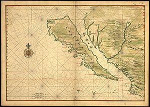
カリフォルニア島
| カリフォルニア島 | |
|---|---|
 1650年頃のカリフォルニアの地図 | |
| 所在地 |
|
| 所在海域 | カリフォルニア湾(太平洋) |
| 最大都市 | ティフアナ |
ウィキデータ項目に座標がありません | |
カリフォルニア島︵カリフォルニアとう、Island of California︶は、バハ・カリフォルニア半島が北米大陸本土と陸続きではなく、カリフォルニア湾に浮かぶ大きな島であるという、ヨーロッパ人が長年信じていた誤解を指す。この﹁疑存島﹂に関する説は16世紀にさかのぼるが、以後も18世紀まで信じられ続けた。
これは史上最も有名な地図製作の間違いのひとつであったが、様々な探検家がバハ・カリフォルニアは半島であるという証拠を報告し続けたにもかかわらず、17世紀と18世紀にも多くの地図にカリフォルニア島が描かれ世界に伝播されていた。この説には当初、カリフォルニアがエデンの園やアトランティスのような、この世の極楽であるという伝説が影響していた。

アニアン海峡を経由して太平洋とヨーロッパを直結する航路。カリフォ ルニア湾はアニアン海峡につながる海峡として描かれている
しかし、この証拠にもかかわらず、17世紀初めに島としてのカリフォルニアの描写が復活した。ひとつの要因として、1592年のフアン・デ・フカの偽の功績があったと考えられる。フカは﹁北米大陸の西海岸を探検し、途中で大西洋につながるとみられる大きな湾を発見したため、これを通って北の海へと往復した﹂と主張した。当時は北米大陸と中国大陸の間には細く曲がりくねった﹁アニアン海峡﹂があるという説があり、この想像上の海峡がヨーロッパからアジアへの最短距離である北西航路になりうるとしてヨーロッパ人による北極海や太平洋岸の探検が行われていた。このため、メキシコとカリフォルニア半島の間の海はアニアン海峡へ繋がり北西航路の一部をなしているのではないかと考えられていた。
またカリフォルニアが島であるという説に影響を与えたのは、ヌエバメヒコ︵ニューメキシコ︶を創設したフアン・デ・オニャーテ総督が率いた徒歩による遠征であると思われる。遠征隊は1604年から1605年までコロラド川を下ったが、彼らはカリフォルニア湾に終わりがなく北西の彼方まで続いているのを見たと信じた。オニャーテの遠征の報告は、1602年から1603年にかけてカリフォルニアの西海岸を探検したセバスティアン・ビスカイノの遠征に参加したカルメル会修道士、アントニオ・デ・ラ・アセンシオンの耳に届いた。アセンシオンはカリフォルニアへのスペイン人の定住を支持した精力的な布教者で、後の彼の文章にはその領域は﹁島﹂と書かれている。
こうしてカリフォルニア島は1622年、アムステルダムのミシェル・コリジン作成の地図上に、再び出現した。17世紀を通して、断続的に18世紀にも、この地形描写は多くの世界地図の標準となった。
しかし、1692年にアリゾナ州を訪れ1700年にツーソン近郊に聖ザビエル伝道教会を設立したイエズス会宣教師で地図製作者のエウセビオ・フランシスコ・キノは、バハ・カリフォルニアが半島であるとする考えを復活させた。ヨーロッパで勉強している頃、キノはカリフォルニアが島であると学んだが、ヌエバ・エスパーニャに着いた後に疑いを持ち始めた。彼は1698年から1706年、ソノラ北部からコロラド川デルタ内やその近くの領域まで、何度も陸路の遠征を行った。これはソノラとバハ・カリフォルニアにあるイエズス会の伝道所間に実用的な道を提供するための遠征だったが、地理的な疑問も解決した。キノ自身はカリフォルニアとメキシコの間の陸地が繋がっていることを知って満足し、18世紀のイエズス会員も一般的に彼の例にならった。しかしキノのいくつかの遠征で軍事的な同伴者となっていたフアン・マテオ・マンヘはキノの説に疑いを持ち、ヨーロッパの地図製作者たちもこの問題で二分されたままであった。
最終的に問題解決を試みたのは、バハ・カリフォルニアでのイエズス会の伝道遠征の探検家、フアン・デ・ウガルテ︵1721年︶、フェルディナンド・コンスカック︵1746年︶、ウェンセスラウス・リンク︵1766年︶らであった。1774年から1776年にかけてフアン・バウティスタ・デ・アンサがソノラとカリフォルニアの西海岸の間を遠征した際にカリフォルニアが半島であることが確認され、この件のすべての論争に決着がついた。
歴史[編集]
﹁カリフォルニア島﹂の伝説に最初に触れたのは、1510年7月にスペインのセビリアで発行されたロマンス小説﹁エスプランディアンの武勲﹂︵ガルシ・ロドリゲス・デ・モンタルボ著︶で、これはモンタルボのより有名な物語﹁アマディス・デ・ガウラ﹂の続編であった。モンタルボの一連の作品は、エルナン・コルテスを初めとした初期のアメリカ大陸探検家の動機づけに大きく影響を与えた。モンタルボは島を次の一節のように記述した。 インド諸島の右手にはカリフォルニアと呼ばれるこの世の極楽のような島がある。そこには黒人女性たちが、アマゾネスのように、一人の男性もなしに暮らしている。 また島は断崖絶壁の海岸とアマゾネスたちの軍勢に守られ難攻不落であり、金以外の金属がないためアマゾネスたちの武器も金でできていたという。アマゾネスたちは、島の名の由来ともなったカリフィア︵Califia︶という女王に率いられているとされた。この記述が、初期の探検家がバハ・カリフォルニア半島を﹁伝説の島﹂と誤認することを促した可能性がある[1]。 1533年、エルナン・コルテスの派遣した遠征隊の一員であった航海士のフォルトゥン・ヒメネスは謀反を起こし、その最中にバハ・カリフォルニア半島の南端にあたるラパス︵バハ・カリフォルニア・スル州︶周辺の陸地を発見した。ラパス周辺の探検はコルテス自身が引き継いだ。ラパスには入植地が作られたが、そのすぐ後に放棄されてしまった。バハ・カリフォルニア南端のみの情報を得たコルテスは、恐らくは伝説的なカリフォルニア島にちなんで、また発見した陸地が大きな島だという前提の下に、その地域を﹁カリフォルニア﹂と命名した[2]。 1539年、コルテスは航海士のフランシスコ・デ・ウリョアを、バハ・カリフォルニアの東岸沿いに北方に派遣した。ウリョアは湾の最奥でコロラド川の河口に到達しており、カリフォルニアが島というより半島であることが証明された。エルナンド・デ・アラルコンの率いる探検隊はコロラド川下流をさかのぼり、ウリョアの発見を確認した。続いて16世紀の間にヨーロッパでゲラルドゥス・メルカトルとアブラハム・オルテリウスのものも含む地図が出版され、カリフォルニアは半島として正しく表記された。
脚注[編集]
- ^ 岩根圀和 (2020). ドン・キホーテのスペイン社会史. 彩流社. p. 15. ISBN 9784779157967
- ^ 21世紀研究会 (2020). カラー新版 地名の世界地図. 文藝春秋. p. 128. ISBN 9784166612697
参考文献[編集]
- Laylander, Don, 2004. "Geographies of Fact and Fantasy: Oñate on the Lower Colorado River, 1604-1605". Southern California Quarterly 86:309-324.
- León-Portilla, Miguel. 1989. Cartográfica y crónicas de la antigua California. Universidad Nacional Autónoma de México, Mexico City.
- McLaughlin, Glen, with Nancy H. Mayo. The Mapping of California as an Island: An Illustrated Checklist. Saratoga, CA: California Map Society, 1995 .
- Polk, Dora Beale. 1991. The Island of California: A History of the Myth. Arthur H. Clark, Spokane, Washington.
- Tooley, R. V. 1964. California as an Island: A Geographical Misconception Illustrated by 100 Examples from 1625-1770. Map Collectors' Circle, London.
外部リンク[編集]
- California as an Island in Maps - Stanford University
- California as an Island - Antique Maps of the Pacific Ocean
- Mythical Geography: California as an Island - Philadelphia Print Shop Ltd.
