コロマンデル海岸
表示
(コロマンデルから転送)


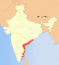
コロマンデル海岸︵英語: Coromandel Coast︶は、インド南東部の海岸。クリシュナ川の河口からカリメール岬に至るまでの海岸を指す。全長は約720キロメートル。
主要な港湾都市の一つ・チェンナイ近郊のマイラポールにポルトガル人が築いた交易拠点の名から、歴史的に日本ではこの地方を﹁サントメ︵桟留︶﹂と呼んだ。綿織物の﹁桟留縞﹂[1][2][3]や、なめし革の﹁桟留革﹂[4]は、この地名に由来する。
地理[編集]
コロマンデル海岸はデカン高原東部の東ガーツ山脈のさらに東側にあるベンガル湾の海岸で、北東モンスーンの影響で10月と11月に雨が多い。クリシュナ川、ペンナ川、パーラール川、ポンナイヤル川、カーヴェーリ川などの河口およびプリカット湖、カリヴェリ湖などの湖があり、主な都市はチェンナイ、ポンディシェリ、カッダロール、ナーガパッティナムおよび石窟寺院などで有名なマハーバリプラムなどがある[5]。 一帯にはベニサガリバナ、アラビアゴムモドキ、フタバナヒルギ、オオバヒルギ、シマシラキなどのマングローブまたはヤシ林が生え、ブロンズトキ、ケリ、レンカク、アジアヘビウ、ホシバシペリカン、クロトキ、ヘラサギ、ゴイサギ、インドトキコウ、シロハラサギ、ヘラシギ、カラフトアオアシシギ、ヒドリガモ、オナガガモ、シマアジ、ジャングルキャット、ボンネットモンキー、ジャッカル、Daboia siamensis、ニシキヘビ属、スナボア亜科、ヒメウミガメ、カエル、魚類、ショウナンエビ、ウシエビ、カニなどの動物が生息している。チェンナイ南郊のパッリカラナイ湿地[6]、カリキリ鳥類保護区[7]、ヴェダンターンガル鳥類保護区[8]、ピチャヴァラム・マングローブ[9]、ヴァドゥヴール鳥類保護区[10]、ウダヤマルタンダプラム鳥類保護区[11]などのラムサール条約登録湿地がある。歴史[編集]
9世紀から13世紀まで続いたチョーラ王朝がこの地に栄えた[5]。
1530年代末までに、ポルトガルが三箇所の交易拠点︵ナーガパッティナム、São Tomé de Meliapore、Pulicat︶を設けた。
しかし、17世紀になるとオランダにナーガパッティナムなどを奪われ、コロマンデル海岸への影響力を失った。一方で、オランダがSadras、Covelongなどにも拠点を置き、イギリスも17世紀前半にマスリパタム、マドラス︵チェンナイ︶などに商館を建て、マドラスにセント・ジョージ要塞を建設した。
フランスもポンディシェリ、カーライッカール、ニザームパトナムなどに拠点を置いたほか、デンマークもこの地域への進出を図った。こうしたヨーロッパ諸国による進出は、インド産綿布を扱うことを目的としていた。最終的にはイギリスがこの地域を確保したが、わずかながらフランスもポンディシェリなどに拠点を保った。
脚注[編集]
注釈[編集]
出典[編集]
(一)^ “サントメ縞”. デジタル大辞泉. 2022年5月28日閲覧。
(二)^ “4. 海外知識の受容︵2︶暮らしの中の異国”. 江戸時代の日蘭関係. 国立国会図書館. 2022年5月28日閲覧。
(三)^ ﹃南インド002チェンナイ~飛躍する南インドの﹁港湾都市﹂﹄まちごとパブリッシング、2016年、81-82頁
(四)^ “サントメ革”. デジタル大辞泉. 2022年5月28日閲覧。
(五)^ ab“コロマンデル海岸(ころまんでるかいがん)とは? 意味や使い方”. コトバンク. 2023年4月23日閲覧。
(六)^ “Pallikaranai Marsh Reserve Forest | Ramsar Sites Information Service”. rsis.ramsar.org (2022年7月25日). 2023年4月23日閲覧。
(七)^ “Karikili Bird Sanctuary | Ramsar Sites Information Service”. rsis.ramsar.org (2022年7月25日). 2023年4月23日閲覧。
(八)^ “Vedanthangal Bird Sanctuary | Ramsar Sites Information Service”. rsis.ramsar.org (2022年8月3日). 2023年4月23日閲覧。
(九)^ “Pichavaram Mangrove | Ramsar Sites Information Service”. rsis.ramsar.org (2022年7月25日). 2023年4月23日閲覧。
(十)^ “Vaduvur Bird Sanctuary | Ramsar Sites Information Service”. rsis.ramsar.org (2022年10月31日). 2023年4月23日閲覧。
(11)^ “Udhayamarthandapuram Bird Sanctuary | Ramsar Sites Information Service”. rsis.ramsar.org (2022年8月3日). 2023年4月23日閲覧。
