ダートムーア
座標: 北緯50度34分 西経4度0分 / 北緯50.567度 西経4.000度
| ダートムーア | |
| Protected Area | |
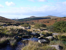
View up the River Meavy towards Sharpitor and Leather Tor | |
| 国 | イギリス |
|---|---|
| Part | イングランド |
| County | デヴォン |
| 最高地 | High Willhays[1] |
| - 標高 | 621m (2,037ft) |
| 最低地 | Doghole Bridge[1] |
| - 標高 | 24m (79ft) |
| 面積 | 954 km² (368 sq mi) |
| 動物 | ダートムーアポニー |
| National park of England | 1951年 |
| 管理 | ダートムーア国立公園局 |
| - 所在地 | ボヴィトレイシー |
| IUCN カテゴリ |
V - 景観保護地域 |
| ウェブサイト: www | |
ダートムーア︵英語: Dartmoor︶は、イギリス・イングランドのデボン州南部に広がるムーア︵湿原︶地形の地域。湿地帯とその周辺の土地はダートムーア国立公園︵Dartmoor National Park︶として保護されている。
自然地理[編集]
地質[編集]
花崗岩で出来た高地で面積は約625平方キロメートルでイギリス最大の面積を有し、山頂付近はたくさんの花崗岩で覆われている。この花崗岩は約3億900万年前の石炭紀にできたと思われる。 スズの採掘や採石など湿原産業用電力の供給源としている。河川[編集]
デボンの川の多くは流域面積を形成している。沼地[編集]
国立公園の多くは泥炭の厚い層に覆われており、雨水を速やかに吸収し、ゆっくりと分散していくので湿原が乾燥していることは稀である。 湿原の植生は種類や場所によって異なる。 降雨量年2000ミリメートルを超えるブランケット湿原では、主に綿草︵ワタスゲ属種︶、ミズゴケ、スゲが繁茂している。気候[編集]
| Princetown[2] | ||||||||||||||||||||||||||||||||||||||||||||||||||||||||||||
|---|---|---|---|---|---|---|---|---|---|---|---|---|---|---|---|---|---|---|---|---|---|---|---|---|---|---|---|---|---|---|---|---|---|---|---|---|---|---|---|---|---|---|---|---|---|---|---|---|---|---|---|---|---|---|---|---|---|---|---|---|
| 雨温図(説明) | ||||||||||||||||||||||||||||||||||||||||||||||||||||||||||||
| ||||||||||||||||||||||||||||||||||||||||||||||||||||||||||||
| ||||||||||||||||||||||||||||||||||||||||||||||||||||||||||||
湿原の中央地付近に所在する、標高453mのプリンスタウン (Princetown) での観測によれば、1月から2月にかけてが一年で最も寒い時期であり、平均気温は1℃である。一年で最も暖かい時期は7月と8月で、平均気温は18℃である。プリンスタウンの東35kmに位置する海岸のテーンマス (Teignmouth) と比較すると、平均気温の最大値と最小値はそれぞれ3.0℃、2.6℃低い値となっており、霜日数は少なくとも5倍ある。
夏にはしばしば驟雨がある。最も雨の多い月は12月で、年間降水量は2000mmを超える。
プリンスタウンにおける1961年から2000年までの50年間の平均気温と比べ、1990年から2000年までの10年間の平均気温は0.2℃上昇しており、晩冬期の気温は0.5℃の上昇を示している。
歴史[編集]
文学[編集]
民俗学者で作家のセイバイン・ベアリング=グールドが1900年に﹃Book of Dartmoor﹄という本を出版している。町[編集]
ダートムーア地域の住民の人口は約3万3000人であるが、ホリデーシーズンには観光客が多く訪れる。国立公園地域内にある最大の集落はアシュバートン︵人口約3500人︶で、このほかバックファストリー、プリンスタウン、イェルヴァートン、ホラブリッジ、サウス・ブレント、チャグフォード、モートン・ハムステッドの集落が存在する。名所[編集]
●リドフォード渓谷 滝がある非常に深く狭い峡谷 ●グリムスポンド - 青銅器時代の集落 ●チャーチハウス(南タウトン) 15世紀の教会のエールハウス ●ツーブリッジ 18世紀の馬車宿 ●タビストック運河 19世紀の運河 ●モルトンハムステッド 歴史的な価値がある17世紀の馬車宿レジャー[編集]
案内所[編集]
公園のメインビジターセンターは、プリンスタウンにある。 ダートムーアの歴史、文化や野生動物についての展示だけでなく、地元の芸術の変遷なども展示している。脚注[編集]
- ^ a b “General Information Factsheet”. Dartmoor National Park Authority. 2008年9月8日時点のオリジナルよりアーカイブ。2009年7月12日閲覧。
- ^ “Princetown 1971-2000 averages”. Met Office. 2007年1月9日時点のオリジナルよりアーカイブ。2008年4月10日閲覧。


